Category Archives for Garmin
Avionics Care: Cleaning and Disinfecting Guidance
Cleaning your Garmin avionics is a great way to not only
maintain a clean cockpit environment, but also help prevent the spread of
disease. Because our products are built with sophisticated electronic
components and touchscreen materials, it’s important to take special care in
choosing which cleaning method is best for your specific Garmin products. Below
are general guidelines for cleaning the touchscreens, buttons, knobs and bezels
on Garmin avionics.
NOTE: The following guidance is intended to help reduce
the spread of disease while preserving the integrity of Garmin aviation
products. Garmin does not guarantee that it will do so in all cases. For
general cleaning and disinfecting guidance, please refer to CDC guidelines and
other applicable guidelines.
Cleaning and Disinfecting:
- Cleaners containing ammonia will harm the antireflective
coating on many Garmin aviation display lenses. - Disinfecting using a solution of 70% isopropyl
alcohol that does not contain ammonia is preferred. Solutions of up to 91%
isopropyl alcohol are also acceptable. - Clean the display lens using a clean, lint-free
cloth and a cleaner that is specified as safe for antireflective coatings. - For other exposed surfaces such as knobs,
buttons and bezels, a damp cloth with soap and water is acceptable. Garmin does
not recommend bleach-based cleaners, ammonia-based cleaners or other harsh
chemicals on any surface. - Remove all soap/soap residue to prevent buttons
and knobs from gumming up or becoming slippery. - Many aviation products are not rated as
waterproof. Spraying or wetting the units to the extent where moisture could go
beyond the exterior surfaces could damage the unit.
This information is sourced from Garmin Service Advisory 2051: Cleaning/Disinfecting Guidance.
The post Avionics Care: Cleaning and Disinfecting Guidance appeared first on Garmin Blog.
https://www.garmin.com/en-US/blog/aviation/avionics-care-cleaning-and-disinfecting-guidance/
Virtual Sun ‘n Fun, AERO Friedrichshafen Experience with Aviation Webinar Series
With the cancellation of several marquee aviation events, our aviation team is bringing an educational line-up of webinars to you. Ranging from an overview of our latest products, such as the GI 275 and GTN Xi series, to cost-effective autopilot upgrades, these free webinars offer pilots and customers a broad overview of our latest avionics solutions, while also providing a general operational overview.
These aviation webinars are scheduled in Central European Time (CET) or Central Time (CT) to accommodate customers’ schedules around the world. Select webinars are also held in German. To sign up for any of the following webinar topics, visit these websites:
SUN ‘n FUN 2020 SEMINAR SCHEDULE
Aviation Webinars
The Latest Products from Garmin: GI 275, GTN Xi and more
Check out the latest avionics
available from Garmin, including the powerful GI 275 electronic flight
instrument and the faster, brighter GTN 650Xi/GTN 750Xi touchscreen navigators.
Autopilot
Retrofits
The GFC 500 and GFC 600 retrofit autopilots offer reduced maintenance, as well as safety-enhancing capabilities such as Garmin Electronic Stability Protection (ESP), underspeed/overspeed protection and coupled approaches. This webinar will focus on the features and benefits of both autopilots.
Cost-effective
Avionics Upgrades
Learn about upgrading an aircraft panel with cost-effective avionics such as the GPS 175, GNC 355 and GNX 375 two-inch navigators, G3X Touch and the GFC 500 autopilot.

Garmin
Services Overview
Learn how cost-effective Garmin database
offerings, apps and web-based solutions can simplify everything from
pre-departure clearances to international flight handling and more.
Garmin
Avionics for Experimental Aircraft
Check out experimental avionics options from Garmin, including the G3X Touch flight display and the G5 electronic flight instrument, GMA 245 audio panels and more.
Spring 2020 Promotions
In
addition to a comprehensive webinar line-up, Garmin is offering the same rebates
and promotions that it planned to offer at the Spring aviation events.
Spring
2020 Avionics Rebate
Customers can receive rebates on select certified avionics, including the GFC 600/GFC 500 autopilots, the GNX 375, GNC 355 and GPS 175 navigators, select audio panels and more. Eligible purchases must be made between March 30 and April 6. Attend one of the webinars above to learn more.
Spring
2020 Portables Rebate
Customers can take advantage of a $150 rebate on the D2 Delta PX, D2 Delta S and D2 Delta aviation watches, and a $100 rebate on the GDL 50/51/52 series. Eligible purchases must be made between March 30 and May 29.
eLearning
Promotion
Through
April 30, customers can receive 10% off normal pricing on the purchase of
eligible eLearning courses, including the G5000 Essentials, GTN Essentials,
Garmin Aviation Weather Radar, Garmin TXi Essentials and the Garmin G3000
Essentials courses.
For
additional information regarding aviation rebates or promotions, visit: https://www.garmin.com/en-US/promotions/aviation/.
The post Virtual Sun ‘n Fun, AERO Friedrichshafen Experience with Aviation Webinar Series appeared first on Garmin Blog.
https://www.garmin.com/en-US/blog/aviation/virtual-sun-n-fun-aero-friedrichshafen-experience-with-aviation-webinar-series/
Garmin Partners with University of Kansas on Environmental Research Plane
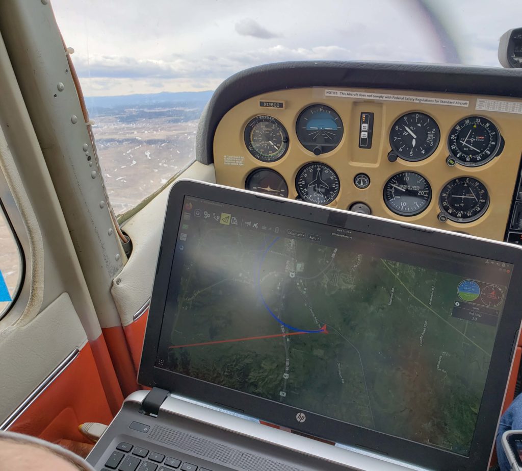
In Lawrence, Kansas, a team at the University of Kansas School of Aerospace Engineering has taken technology from the 1970s and created a tool designed to gather environmental research data. The technology? A 1974 Cessna 172. The team has specially modified the aircraft with an advanced airborne radar designed to measure regional snow thickness throughout South Dakota’s Black Hills region.
The Mission
After spending four years in the hangar, the KU team restored a Cessna 172 to operational status to be used as a vehicle for gathering research data. A specially designed snow radars was installed on the classic Cessna and put into service gathering data throughout the Black Hills. The radars measure snow levels as the aircraft flies grid-like patterns over a specific area.
“The measurements will be used for hydrological models to help predict stream flow,” said Emily Arnold, assistant professor, University of Kansas Aerospace Engineering Department. “If they know how much snow there is, they can help determine how much water is going to run off into a stream and help determine how much water will be available to people within a region as they manage the resource.”
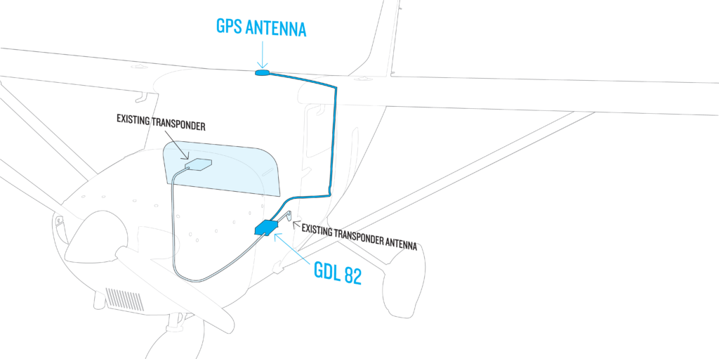
We helped the team meet 2020 FAA ADS-B requirements by providing our GDL 82 ADS-B “Out” datalink. This small, lightweight, easy-to-install 978 MHz universal access transceiver features our patented AutoSquawk technology. It’s a cost-effective solution for aircraft that operate in controlled U.S. airspace below 18,000 feet and was an ideal solution for the KU engineering team because they wanted to keep the aircraft’s existing transponder.
What’s next for the Cessna 172?
“Sense and avoid research with UAVs (unmanned aerial
vehicles),” said Arnold. “The Cessna 172 is a valuable resource within our
department. Having an aircraft like that makes performing our research more
cost-effective.”

To learn more about our GDL 82 ADS-B “Out” datalink, visit Garmin.com/GDL82.
The post Garmin Partners with University of Kansas on Environmental Research Plane appeared first on Garmin Blog.
https://www.garmin.com/en-US/blog/aviation/garmin-partners-with-university-of-kansas-on-environmental-research-plane/
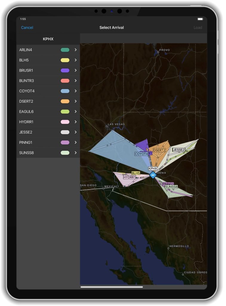
Flight Deck Technology, Tools Added to Garmin Pilot App
Advanced new features and professional IFR navigation tools are now available within our Garmin Pilot app, many of which incorporate a familiar look and feel to our most popular flight decks and avionics. Pilots can experience a near-seamless transition between Garmin avionics and Garmin Pilot when performing common functions, such as loading and activating instrument approach procedures, departures and arrivals within the Americas. Additional features such as a visual procedure selector, custom holding patterns and more, give pilots convenient access to advanced tools all within a mobile app.
“Leveraging technologies found within Garmin avionics and flight decks,
we’re excited to bring this game-changing update to Garmin Pilot customers,” said
Carl Wolf, vice president of aviation sales and marketing. “This latest upgrade
gives pilots the ability to load complex routes and procedures into the app
just as they would within a Garmin integrated flight deck, offering added
convenience, time savings and confidence when transitioning between multiple
Garmin products in the cockpit.”
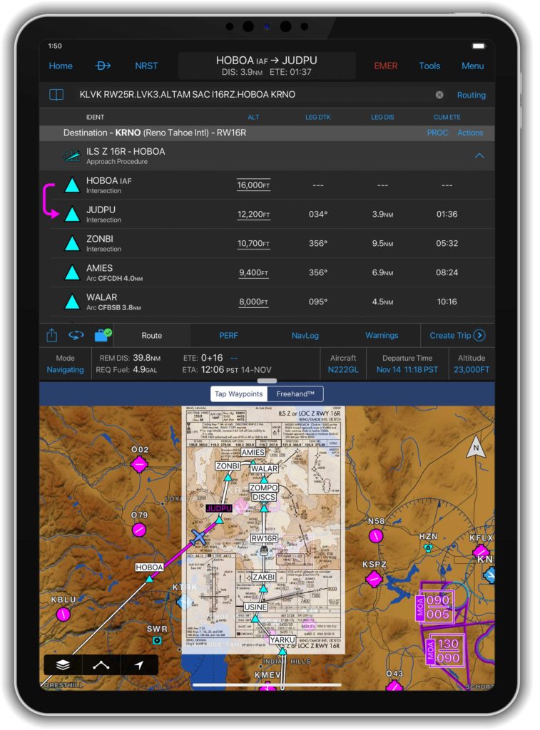
Professional IFR
navigation tools
Within the
latest Garmin Pilot upgrade, pilots have the option to load or activate departures,
arrivals and instrument approach procedures. Published holds that are included
as part of the missed approach are also added to the flight plan. When pilots
activate a procedure with published altitude constraints, those altitudes are automatically
incorporated into a flight plan within the app. Pilots can also choose to manually add altitude constraints to a flight
plan. Additionally, approach procedures with radius-to-fix (RF) legs can be
activated within Garmin Pilot.
Using the
vertical planning feature within Garmin Pilot, pilots can more easily input and
adhere to crossing restrictions in a flight plan. For example, pilots can
manually input a crossing restriction over a specific navigational aid or GPS
waypoint. With these new features, pilots can optimize their flight planning
and fuel calculations.
Visual procedure selector
Pilots can
now more easily visualize departures, arrivals and instrument approach
procedures prior to a flight using the visual procedure selector. This new
selector allows pilots to simultaneously view departures, approaches or arrivals
on a map alongside a flight plan so it’s easier to visualize and select the
most appropriate procedure based on a flight plan and intended direction of
flight.
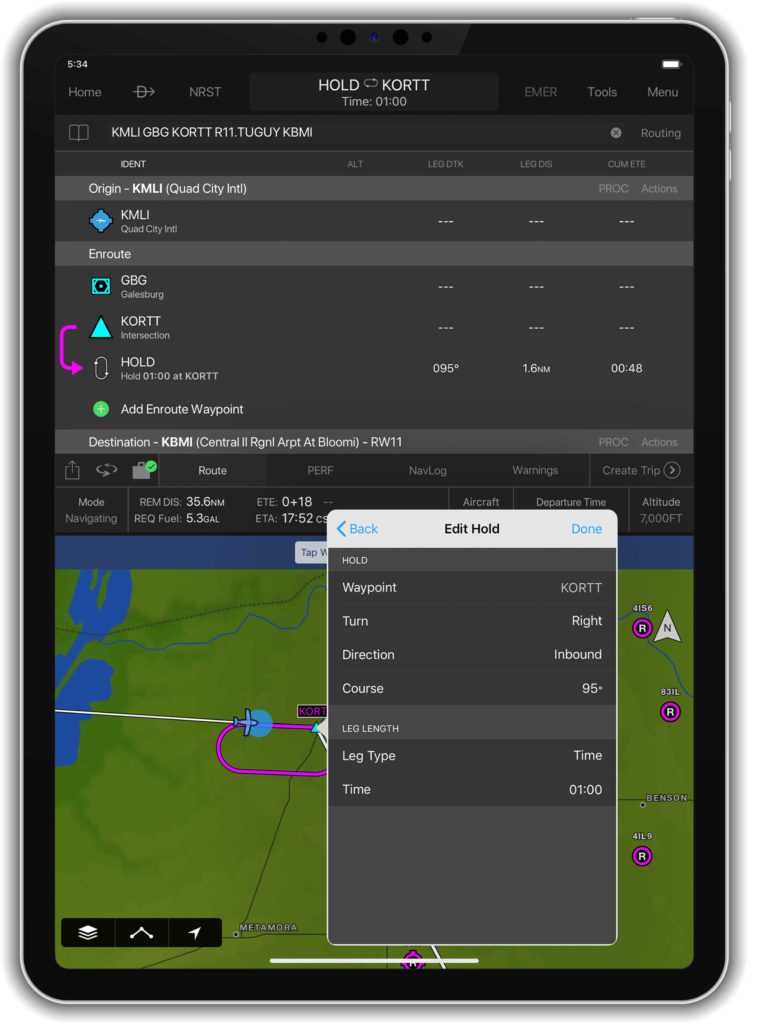
Customized
holding procedures
Pilots now have the flexibility to easily
build customized holding patterns. These holds may be created over an existing
fix or over a user-defined waypoint and then inserted into a flight plan. When
creating a hold, pilots can easily input an inbound or outbound course, select
left or right turns and specify leg length in time or distance. Unpublished
holds or those assigned by air traffic control are easily created and displayed
within Garmin Pilot to simplify the process of visualizing and flying a holding
pattern.
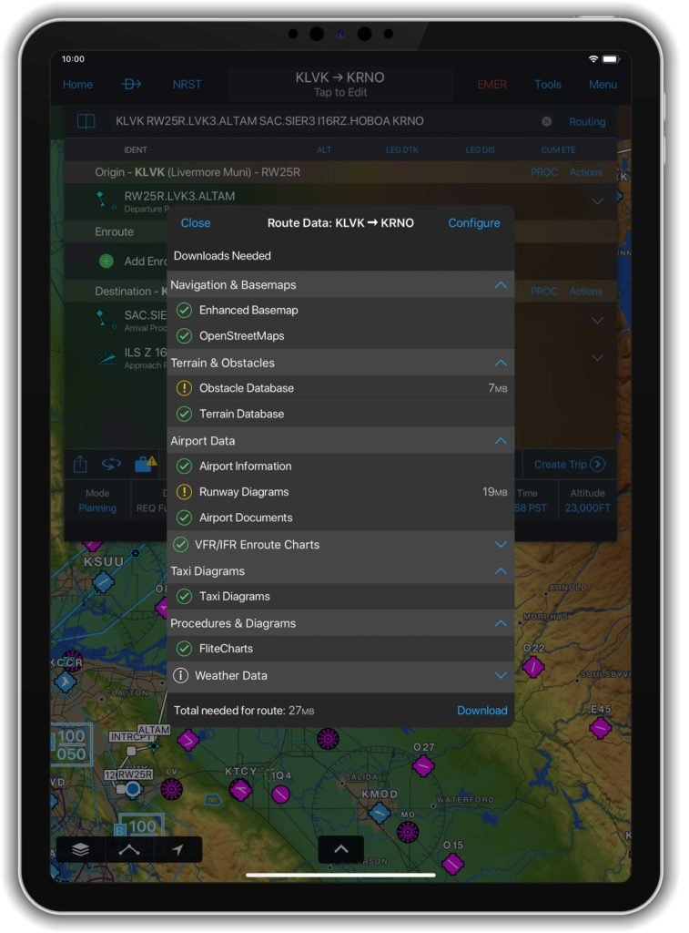
Worldwide
route data packages
Route data packages within Garmin Pilot help to ensure pilots have downloaded all of the data required for a flight plan. Once a flight plan is entered, pilots can review the data that is downloaded to their mobile device. If information is missing for a particular flight, Garmin Pilot displays an option to download additional data. Route data packages are also available worldwide to help ensure pilots have all of the data they need prior to every flight. Databases that are included within the worldwide route data packages include navigation data, instrument approach procedures, SafeTaxi, terrain, obstacles and more.
The newest release of Garmin Pilot on Apple mobile devices is available immediately. For new customers, Garmin Pilot is available in the Apple App Store as a free download for the first 30 days. After the 30-day trial period, customers may purchase an annual subscription of Garmin Pilot starting at $79.99.
The post Flight Deck Technology, Tools Added to Garmin Pilot App appeared first on Garmin Blog.
https://www.garmin.com/en-US/blog/aviation/flight-deck-technology-tools-added-to-garmin-pilot-app/
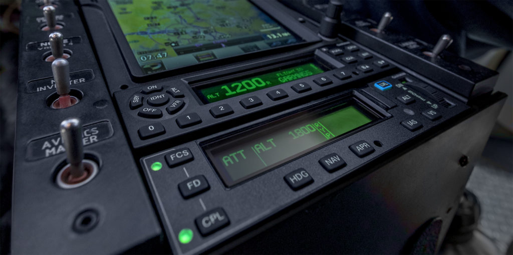
GFC 600H Helicopter Flight Control System Approved in AS350
Our GFC 600H helicopter flight control system has achieved FAA Supplemental Type Certification in the AS350 B2/B3. This attitude-based flight control system boasts a number of helicopter-tailored safety features, including attitude hold, Garmin Helicopter Electronic Stability and Protection, dedicated return-to-level mode, hover assist, as well as overspeed and low speed protection. The GFC 600H requires the Garmin G500H1 or G500H TXi flight display and offers integration with compatible instruments and navigation sources.
With advanced AHRS technology and redundant, cross-checking sensors, GFC 600H was designed for smooth handling, providing inputs to help stabilize the helicopter while hand-flying. The stability provided by the system offers significant workload reduction and great benefits to helicopter operators by maintaining a commanded attitude. Designed with the pilot in mind, its cyclic-mounted trim controls allow for seamless interactions without taking a hand off of the helicopter flight controls during basic operations, including system initialization of attitude hold mode, adjustments of the pitch and roll trim, and much more. While flying in attitude hold mode, pilots can easily “fly through” the flight control inputs for smooth maneuvers beyond the preset trim condition.
Hover Assist
Hover assist mode is capable of automatically detecting a hover condition, and provides flight control inputs to help maintain position over the ground. With the optional yaw axis control, the GFC 600H will also hold heading while in a hover. In addition to hover assist mode, groundspeed hold2 is also available, allowing the pilot to input a forward or sideways command, which can be particularly useful during taxi and take-off.
Garmin H-ESP
Garmin Helicopter Electronic Stability and Protection (H-ESP) helps the pilot remain within a safe flight envelope when hand-flying the helicopter. H-ESP works in all modes – even when the system is not engaged – and can be manually disabled to allow for maneuvering flight. The GFC 600H also features a dedicated level mode that can be engaged by the pilot to return to straight-and-level flight, helping to avoid a potential loss-of-control scenario.
For
enroute and approach navigation, the system uses guidance from a compatible
Garmin navigator, such as the GTN 750/650 series, to automatically fly
approaches and search and rescue patterns. Additional vertical and lateral
modes include altitude hold, altitude select, vertical speed, indicated
airspeed and heading select.
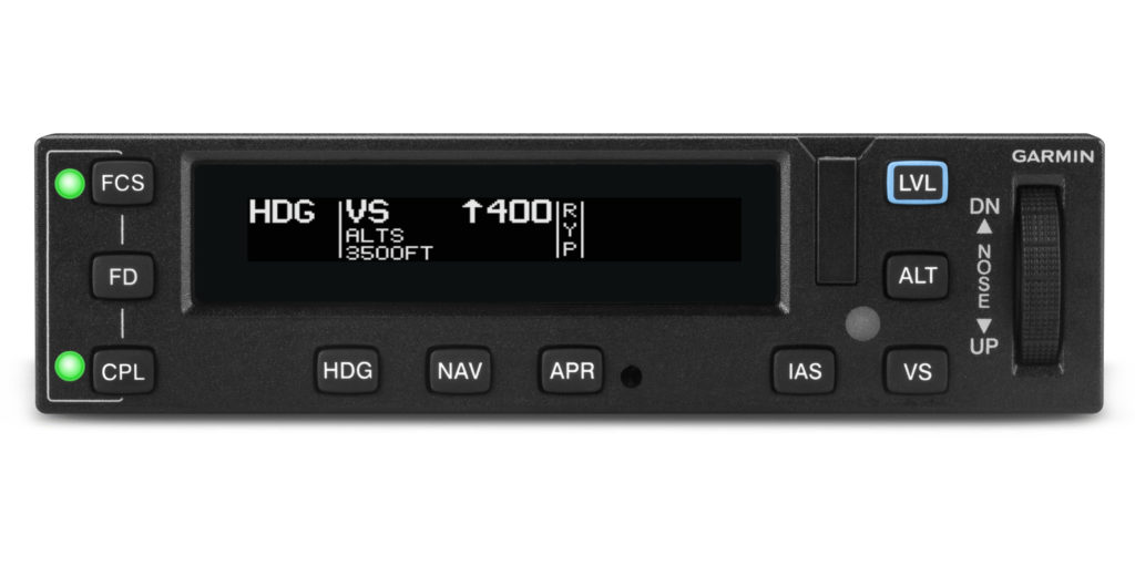
The
GFC 600H features a stack-width mode controller with push-button controls and a
night vision goggle (NVG) compatible display. Its robust architecture supports a
3-axis configuration to provide the features and handling characteristics
needed for a helicopter. Integrated “smart” servos provide pitch and roll
inputs as commanded by the system, and the available third servo and collective
sensor provide yaw axis control capability and smooth flight control
adjustments when the pilot moves the collective. Digitally controlled,
high-torque servos allow for faster, crisper, more powerful response, which
enables the GFC 600H to perform with smooth efficiency and advanced capability.
With its extensive features and advanced technology, the GFC 600H offers unprecedented value at a competitive price. It is supported by our award-winning aviation product support team, which provides 24/7 worldwide technical and warranty support.
1.Requires additional sensors.
2.Requires a GTN 650/750 or GTN 650Xi/750Xi touchscreen navigator.
The post GFC 600H Helicopter Flight Control System Approved in AS350 appeared first on Garmin Blog.
https://www.garmin.com/en-US/blog/aviation/gfc-600h-helicopter-flight-control-system-approved-in-as350/
Alaska Flight School Teaches Pilots to Fly in World’s Remote Areas
Don Lee, owner of Alaska Floats & Skis flight school in
Talkeetna, Alaska, has felt the ground below him shake from the pounding of thousands
of caribou hooves. He’s discovered areas so abundant with blueberry bushes, it
was impossible to sit down. He’s looked down at water thick with layers of
migrating fish.
Lee is a flight instructor with decades of experience. He
prides himself on running one of the only flight schools in the world that can
teach pilots how to land off-airport on glaciers, mountains and in water. But
Lee is also passionate about discovering untouched places in Alaska — the Last
Frontier — the vast and beautiful state he’s called home since high school.
Growing up in Minnesota, Lee knew that flying was his
calling. But when he packed up after high school and hitchhiked to Alaska to
live in the bush, becoming a pilot became a necessity more than anything. It
was the only way to get in and out.
He began with flying for lodge support in Alaska and later
branched into guiding hunters and fishermen. Lee then operated an on-demand air
service for many years. He’s flown all over the world, provided air support for
climbers on Denali, performed more than 6,500 glacier landings and gained more
than 8,500 hours in floatplanes alone (with a total airtime of more than 19,000
hours).

Glaciers, Mountains,
Water
At Alaska Floats & Skis, established in 2002, Lee and
his team of flight instructors communicate that valuable knowledge to other
pilots looking to escape to remote areas. It’s one of the few schools in the
world that teaches pilots how to maneuver a ski-plane and land on glaciers —
half of which is survival training.
“You can’t teach people how to access and land in these
incredibly remote areas without teaching them how to survive if something
happens,” Lee said. “It’s very extreme. But it’s very beautiful, pristine and
quiet out there. It’s absolutely breathtaking to go to the mountains and land
on these glaciers.”
With five floatplanes in their fleet, Alaska Floats & Skis
completes from 85 to 90 seaplane ratings a year, right off their dock on
Christiansen Lake. The course is 90% water work — how to dock, how to taxi, how
to land in rough water conditions, how to read the wind and more.
“The seaplane rating is a wonderful rating to have because
it gives you so much more access to the country,” Lee said.
The bush pilot course teaches students off-airport
techniques and how to land in rough areas such as gravel bars, mountaintops and
wilderness strips. Situated at the base of Mount Denali, pilots flying through
the mountain range can experience what it’s like to have something like 15,000
vertical feet about them and 8,000 vertical feet below, an experience that Lee
describes as “very challenging and very rewarding.”
“With the off-airport courses, what we’re really teaching is
what pilots should be thinking,” Lee said. “Is the runway long enough? Is it
hard enough? Soft enough? Which way is the wind blowing? Where’s your rising
air? Where’s your descending air? Are your passengers a liability or an asset?”

Risk vs. Reward
Lee teaches all pilots to weigh risk versus reward and avoid damaging a plane or putting themselves in danger at all costs, but he also has a safety protocol in place if something happens. That includes having an inReach® satellite communicator in each of his planes.
Using his fleet of inReach devices, Lee can track all of his
airplanes in real time, overlaid on an aeronautical chart.
“Garmin has revolutionized our safety protocol,” he said. “I
now know where every one of my airplanes are for every minute of their flight
time. Alaska is so big, and our business is so busy that it’s vital I know
where those airplanes are at all times.”
In the remote Alaskan wilderness, the majority of which
doesn’t have cellphone service, Lee and his flight instructors also use their inReach
devices to communicate.
“We have the option to text different things like ‘We need
help’ or ‘We’re having a good time, so give us another hour,’ or ‘We’re OK, but
send somebody out’,” Lee said. “That’s invaluable.”
Plus, if something does go wrong, the instructors simply
have to trigger an SOS to initiate a rescue.
“Heaven forbid something did go wrong, we could get
emergency services there immediately,” Lee said.

A Flying Experience
Over the years, Lee has built much more than just a flying
school. At Alaska Floats & Skis, it’s an experience.
Participants and their nonpilot families and friends are
invited to stay at the Alaska Floats & Skis lodge, located near
Christiansen Lake, for the duration of their flying courses. They encourage
people to socialize and enjoy the surrounding area — to explore or hike in the
nearby mountains or canoe and fish in the surrounding lakes.
There’s a big firepit and a pizza oven on site, and Lee
hosts free pizza nights twice a week (and even covers the cost of pizza and
beverages).
“We encourage camaraderie,” Lee said. “It’s kind of a flying
experience. Being here, we’re really fortunate with all of the availability for
recreation and exploration.”
And, ultimately, exploration is what he’s all about.
“To be able to go into the mountains and glaciers where it’s
so incredibly pure and expansive … ” Lee said. “It’s so invigorating.”
NOTICE: To access the Iridium satellite network for live tracking and messaging, including SOS capabilities, an active satellite subscription is required. Some jurisdictions regulate or prohibit the use of satellite communications devices. It is the responsibility of the user to know and follow all applicable laws in the jurisdictions where the device is intended to be used.
The post Alaska Flight School Teaches Pilots to Fly in World’s Remote Areas appeared first on Garmin Blog.
https://www.garmin.com/en-US/blog/outdoor/alaska-floats-and-skis/
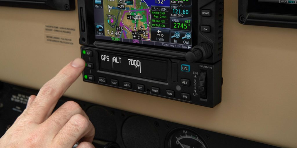
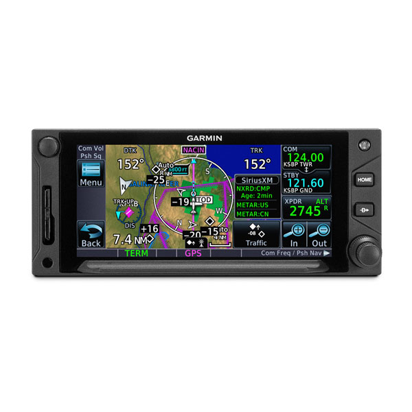
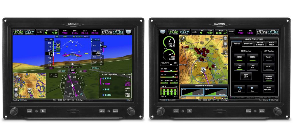
GTN Xi Series: Fourth Generation GPS/NAV/COMM Solutions
The next generation of in-flight navigation technology has arrived. Our GTN 650Xi and GTN 750Xi—the fourth generation of GPS/NAV/COMM solutions—are designed as a direct slide-in upgrade to the previous generation GTN 650/750, allowing pilots to preserve their panel and modernize the cockpit at the same time. The all-in-one GPS/NAV/COMM boasts a feature-rich multifunction display and can integrate with new or existing remote-mount equipment such as a transponder or audio panel. Dual-core processors and modern hardware also prepare the GTN Xi series for advanced capabilities in the future. The GTN 650Xi and GTN 750Xi have received FAA approval and are available immediately for fixed-wing single-engine and multi-engine piston, turbine and experimental aircraft, with helicopter and business aircraft approvals soon to follow.
“After decades of innovation and pioneering the GPS/NAV/COMM, we’re excited to bring the fourth
generation GTN 650Xi and GTN 750Xi to the market,” said Carl Wolf, vice president of aviation sales and
marketing. “Garmin was the first to introduce the all-in-one navigator with the iconic GNS 430/530. Over
time the GNS WAAS and the industry-first GTN 650/750 touchscreen navigators were added to the line-
up along with state-of-the-art features such as voice control, wireless connectivity and more. As the
leader in GPS cockpit navigation, we have brought the most widely adopted navigators to the industry
and with the GTN 650Xi and GTN 750Xi, we’re excited to add one more to the family.”
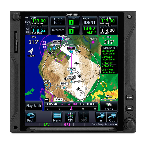
Modern processing power and state-of-the-art hardware within the GTN 650Xi/750Xi supports faster map
rendering and smoother panning throughout the touchscreen navigator. It boasts a large, ultra-high-
resolution display and wide viewing angle that offers superior readability in the cockpit. The displays
initialize within seconds of start-up, providing immediate access to frequencies and flight plan
information, saving valuable time in the aircraft. Preserving the same form factor as the previous
generation GTN 650/750, the 6-inch-tall GTN 750Xi and the 2.65-inch-tall GTN 650Xi offer an intuitive
touchscreen design with a dedicated direct-to button and dual concentric knob that provide added
convenience when interfacing with the display.
Retaining all the features of the GTN 650/750, the GTN Xi series adds a vibrant display and vivid colors
that enhance the contemporary look of the new navigators. When installed alongside a G500 TXi or
G600 TXi flight display, the GTN Xi series brings a new level of modernization to the cockpit. Highly
complementary, the GTN Xi and the TXi flight displays share similarities in display, appearance and
hardware qualities. For example, both products feature an angular bezel so the pilot has a near-seamless
experience when transitioning between the touchscreen flight display and the navigator.
The GTN 650Xi/750Xi offer advanced navigation functions, including ILS and LPV instrument approach
procedures, as well as visual approach guidance. Based on a published glide path angle or a three-degree
glideslope from the threshold of the runway, visual approaches also take into account terrain and
obstacle clearance to assist pilots in flying a stabilized approach to the runway in visual flight conditions.
Approach types that incorporate radius-to-fix (RF) leg types are also supported by the GTN Xi series.
Additional capabilities include the option to add a published or custom holding procedure, vertical
navigation (VNAV), graphical flight plan editing on the moving map and more.
The colorful, multifunction display-like map allows pilots to better visualize their dynamic position relative to potential hazards, such as terrain, weather and traffic. Geo-referenced instrument approach procedures can be overlaid on the map page, offering superior situational awareness when transitioning from the enroute to approach phase of flight. Terrain alerting is included within the GTN Xi series and further enhances situational awareness by using its internal terrain and obstacle database to provide audible and visual terrain proximity alerts, including, “terrain ahead, pull up” and “obstacle ahead, pull up.” Helicopter Terrain Awareness and Warning System (HTAWS), TAWS-A and TAWS-B are available as options.
Superior integration with an array of avionics on the market make the GTN 650Xi/750Xi a simple and straightforward solution to incorporate into any cockpit. Options for remote audio panel or transponder display and control allow aircraft owners to simplify their panel. When paired with a Garmin autopilot, such as the GFC 500 or GFC 600, pilots can fly fully coupled VNAV profiles and instrument approach procedures. Pilot workload-reducing features such as Telligence voice control is also available within the GTN Xi when paired with the optional GMA 35c. When paired with a GSR 56 Iridium datalink, global text and voice calling can be completed through the touchscreen display on the navigator.
Wireless connectivity is available with the optional Flight Stream 510, allowing pilots to connect their mobile devices running the Garmin Pilot and FltPlan Go applications to the GTN 650Xi/750Xi. When connected to the navigator, pilots can save time in the cockpit by wirelessly transferring aviation databases and flight plans from their mobile device to the navigator. Flight Stream 510 also supports the sharing of traffic, weather, GPS position information and more. The GTN Xi series is also compatible with the cost-effective Garmin navigation database.
The GTN 650Xi and GTN 750Xi have received FAA Supplemental Type Certification (STC) and are available immediately through Garmin Authorized Dealers for a suggested retail price of $12,495 and $17,995 respectively. A free GTN Xi trainer app is also available for download on Apple mobile devices, which allows customers to experience the feature set of these navigators. A new GTN Essentials 2.0 eLearning Course provides instruction on best practices for operational use of the new GTN Xi series and can be accessed here. The GTN Xi series come with a two-year warranty and are supported by Garmin’s award-winning aviation support team, which provides 24/7 worldwide technical and warranty support. Garmin was awarded top honors last year in avionics product support for the 16th straight year by Aviation International News, and earned the top spot in the annual avionics product support survey conducted by Professional Pilot magazine this year, also for the 16th consecutive year. For additional information, visit www.garmin.com/GTNXi.
The post GTN Xi Series: Fourth Generation GPS/NAV/COMM Solutions appeared first on Garmin Blog.
https://www.garmin.com/en-US/blog/aviation/gtn-xi-series-fourth-generation-gps-nav-comm-solutions/
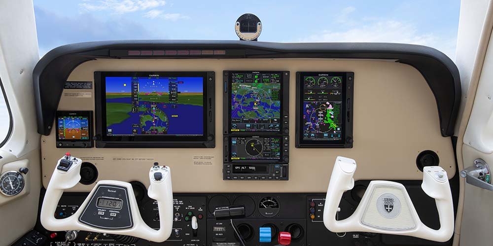
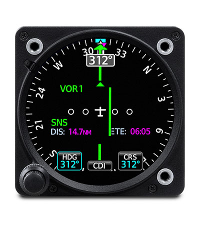
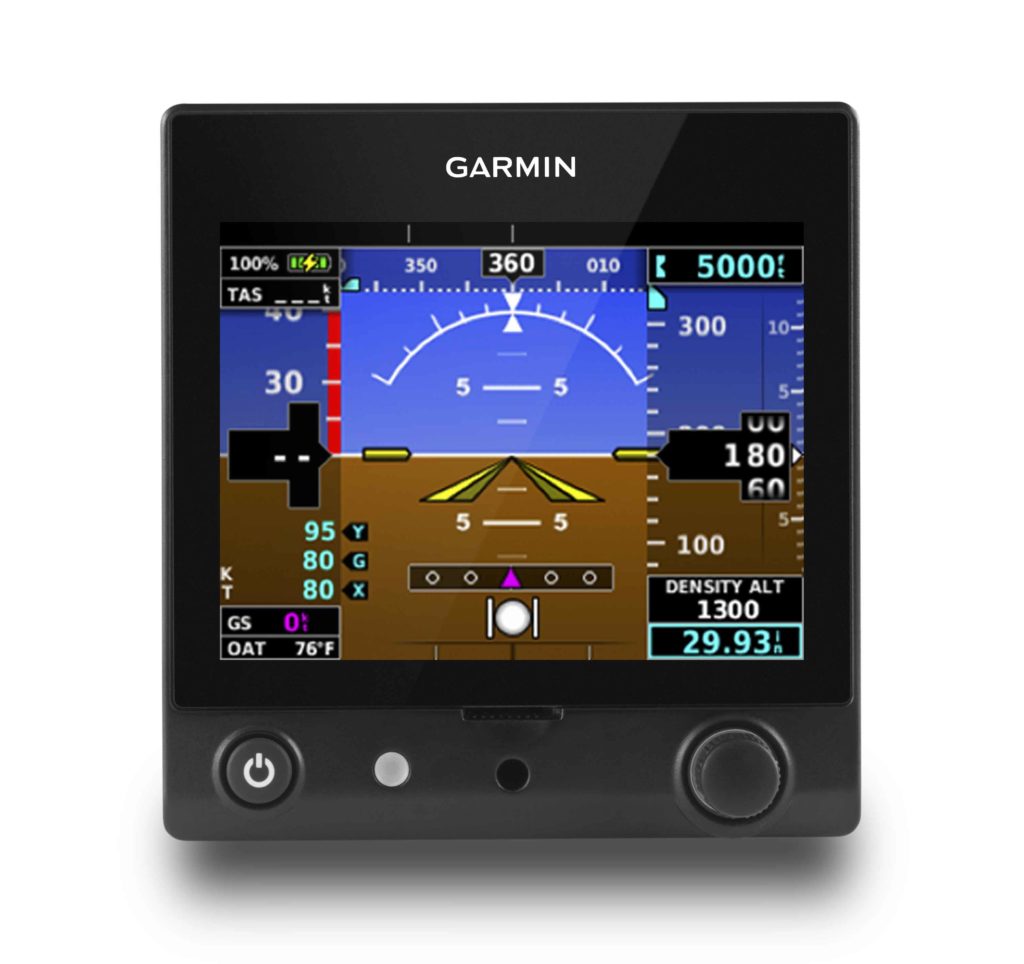
GI 275: Aircraft Flight Instrumentation Reimagined
Introducing GI 275, a powerful electronic flight instrument that directly replaces legacy primary flight instruments in the cockpit. The GI 275 is suitable as a direct replacement for a variety of instruments including, an attitude indicator, attitude directional indicator (ADI), course deviation indicator (CDI), horizontal situation indicator (HSI) and engine indication system (EIS). Capable of serving as a 4-in-1 flight instrument, the GI 275 can also be installed as a standby to a number of glass flight displays and is available with a 60-minute back-up battery. Lightweight and compact, it is intentionally designed to take advantage of the common 3.125-inch flight instrument size, reducing installation time and preserving the existing aircraft panel. It’s also compatible with a variety of third-party autopilots and does not require a separate interface adapter, further reducing installation labor. The GI 275 has received FAA approval and is available immediately for installation in over 1,000 single-engine and multi-engine aircraft models.
Several variants of the GI 275 are available to meet the needs of over one thousand business and general aviation aircraft models. Features beyond the traditional display of attitude, airspeed and altitude include the option to display CDI, HSI, and engine information. The GI 275 is also capable of displaying multifunction display-like features, such as traffic, weather, terrain, SafeTaxi airport diagrams, optional Synthetic Vision Technology (SVT) and more.
“As constant innovators within the avionics industry, we’re redefining
the aircraft cockpit with the introduction of the GI 275,” said Carl Wolf, vice
president of aviation sales and marketing. “With the GI 275, pilots can
take an economical and scalable approach to their avionics upgrade, while
saving on the installation labor and cost. If it’s round and in their panel,
pilots can likely replace it with the GI 275 to receive modern flight display
features and benefits in a powerful, yet compact touchscreen flight
instrument.”
Suitable as a replacement to many aging flight instruments and
gyro-based attitude indicators on the market such as the popular KI-256, the GI
275 gives aircraft owners the benefits of a modern and reliable flight
instrument. The GI 275 boasts a standard 3.125-inch form factor and rear-mount
design that minimizes panel modification. Its bright, high-resolution touchscreen
display and wide viewing angle offers superior readability in the cockpit. A
dual concentric knob allows pilots to access a variety of key functions within
the flight instrument, such as adjustments to the baro setting or the airspeed
bug. Highly scalable, aircraft owners can start with a single GI 275 and add up
to a total of six in a single panel, paving the way for incremental upgrades
and an array of individualized panel configurations.
Primary attitude indicator
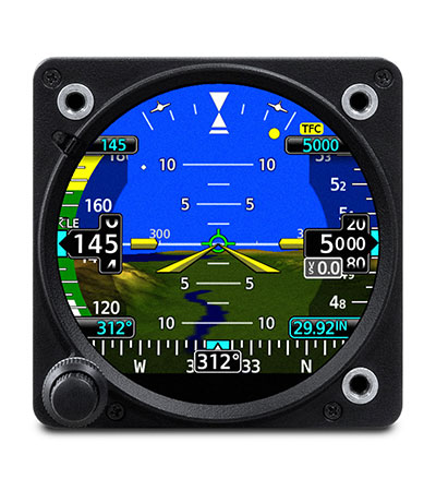
When installed as a primary attitude indicator, the GI 275 offers improved reliability, potential weight savings and reduced maintenance compared to failure-prone vacuum-driven attitude indicators. When the GI 275 serves as primary for attitude information, pilots can also view altitude, airspeed and heading on the instrument. Optional SVT overlays a rich, 3D topographic view of terrain, traffic, obstacles, airport sign posts and more all within the GI 275 attitude display. The GI 275 also overlays a flight path marker within the SVT view, which takes into account crosswind, angle of attack and other factors to show precisely where the aircraft if flying.
The 4-in-1 GI 275 flight instrument is also approved for installation as
a dedicated standby flight instrument to Garmin glass flight displays and is
capable of serving as a back-up to a variety of third-party flight displays on
the market. When installed as a standby to the G500 TXi, the GI 275 is capable
of displaying additional multifunction display features. For back-up navigation
information, a built-in VFR GPS enables convenient direct-to navigation
guidance, displaying aircraft position information on a moving map. In
installations where the GI 275 is installed as a primary or standby flight
instrument, a 60-minute back-up battery is included.
Course Deviation Indicator (CDI) & Horizontal Situation Indicator
(HSI)
When installed as a CDI or HSI, the GI 275 is designed to accept a
variety of GPS or navigation inputs, allowing up to two GPS sources and two VHF
navigation sources. The GI 275 features an Omni Bearing Resolver that allows
the flight instrument to interface to a variety of legacy navigators on the
market without the need for an expensive adapter. With an optional magnetometer,
it is also capable of providing magnetic-based HSI guidance. Vertical and
lateral GPS, VOR/LOC and glide slope deviation can be viewed on the GI 275. CDI
source selection can be accomplished through the touchscreen interface, while
course and heading selection is completed using either the touchscreen or dual
concentric knob. When pilots replace an older mechanical CDI or HSI, the GI 275
doubles as a modern digital indicator and adds MFD-like capabilities such as a
moving map, weather, traffic and terrain.
Suitable as a replacement to display primary engine information
When configured as primary to display engine information, the GI 275 is capable of interfacing with single-engine and multi-engine normally aspirated or turbocharged aircraft with select powerplants, including Lycoming and Continental 4/6-cylinder engines. When the GI 275 replaces mechanical gauges and is configured as primary for engine information, the GI 275 can display RPM, manifold pressure, oil pressure and temperature, cylinder head temperature (CHT), exhaust gas temperature (EGT), turbine inlet temperature (TIT), fuel flow, fuel quantity, fuel pressure, volts and amps. Lean assist functionality is also available so pilots can choose to operate rich of peak or lean of peak. The GI 275 also features exceedance alerting, allowing installers to configure caution and warning alerts per the Pilots Operating Handbook (POH). Advisory alerts such as “high oil temp” or “high CHT” can be configured by the pilot. These exceedances, as well as additional engine data can be shared wirelessly with the Garmin Pilot app on Apple mobile devices and can also be viewed on the flyGarmin website for post-flight analysis. In multi-engine aircraft, dual GI 275’s are required to display engine information.
Multifunction Display
Depending on the configuration and installation, the GI 275 is capable
of displaying additional page functions and features beyond a traditional
flight instrument. These features can include:
- A multifunction display (MFD) with a moving map can display terrain, obstacles, traffic, weather, airspace information, airways, and more.
- When interfaced to a GTX
 345 or GNX 375, traffic information can be displayed on the dedicated traffic page or moving map. Patented TargetTrend relative motion technology and pop-up traffic alerts further enhance situational awareness.
 - The GI 275 can also be interfaced to a variety of traffic systems, including select Traffic Advisory (TAS) and Traffic Alert and Collision Avoidance Systems (TCAS). Traffic advisories are displayed on the dedicated traffic page and moving map.
- SafeTaxi airport diagrams display runways, taxiways, Fixed Based Operators (FBO’s), hangars and more relative to the aircraft’s location on the airport surface.
- Terrain shading incorporates yellow and red contouring depicting the aircraft is 1,000 and 100 feet above ground level (AGL) respectively. Terrain information, as well as obstacle and WireAware database information can be viewed on the terrain and map pages.
- The GI 275 uses its internal terrain and obstacle database to provide audible and visual terrain proximity alerts, including, “terrain ahead, pull up” and “obstacle ahead, pull up.”
- When paired with the GDL 69 datalink receiver, the GI 275 is capable of displaying SiriusXM Aviation Weather. It can also display Flight Information Service-Broadcast (FIS-B) weather from either a GTX 345 or GNX 375.
- An airport information page displays a variety of information, including frequencies, runway dimensions and more.
- The GI 275 can be paired with the GRA 55/5500 and other third-party products to display a radar altimeter on a dedicated page. Visual and aural annunciations are also available.
- The GI 275 is compatible with the GFC 600 autopilot, as well as an array of third-party autopilots and can replace the primary attitude indicator installed with these autopilots. GFC 500 compatibility is expected later this year.
Built-in Wi-Fi enables Database Concierge, the wireless transfer of aviation databases to the GI 275. Pilots also have the option of transferring databases to the GI 275 using a USB flash drive and the GSB 15 USB charger. Databases can also be synced among multiple GI 275 flight instruments in a single cockpit. When configured to display engine information, the GI 275 can wirelessly send engine data to display within the Garmin Pilot app on Apple mobile devices. This data is also automatically synced and can also be viewed on the flyGarmin website. Wireless flight plan transfer via Bluetooth is available when the GI 275 is paired with a GPS 175, GNC 355 or GNX 375. Additional wireless functions include the sharing of GPS position and back-up attitude information with Garmin Pilot.
The GI 275 is available immediately and is approved for installation in over 1,000 single-engine and multi-engine aircraft models. Select Class IV aircraft are also approved, visit www.garmin.com/GI275 for additional information. Customers can purchase the GI 275 through the Garmin Authorized Dealer network and pricing for various configurations of the GI 275 can be found on the website. A trial period of SVT also comes with the purchase of a GI 275 when it’s configured as an attitude indicator. The GI 275 also comes with a two-year warranty and is supported by our award-winning aviation support team, which provides 24/7 worldwide technical and warranty support. Garmin was awarded top honors last year in avionics product support for the 16th straight year by Aviation International News, and earned the top spot in the annual avionics product support survey conducted by Professional Pilot magazinethis year, also for the 16th consecutive year. For additional information, visit www.garmin.com/aviation.
The post GI 275: Aircraft Flight Instrumentation Reimagined appeared first on Garmin Blog.
https://www.garmin.com/en-US/blog/aviation/gi-275-aircraft-flight-instrumentation-reimagined/
TeamX Adds New Features to G3X Touch and G5 for Certified Aircraft
Our TeamX avionics engineers for experimental aircraft have added new features and panel configurations to G3X Touch, and cost-effective avionics options approved for installation in certified aircraft. New wireless engine data streaming and flight data logging give pilots additional insight into aircraft and engine performance, and additional G3X Touch display layout options give pilots flexibility when provisioning for a G3X Touch installation in their aircraft. Additionally, new features for the G5 electronic flight instrument include the display of density altitude while on the ground and the option to display additional data fields when the G5 is paired with the GTN 650/750 or the GPS 175/GNC 355 or GNX 375. These new software, display options and new hardware approvals are available immediately.
G3X Touch for certified aircraft
Pilots are provided with a comprehensive,
in-depth look at engine performance and trend data with G3X Touch for
certified aircraft, which includes built-in flight data logging and optional
engine monitoring. Aircraft performance, engine data and any exceedances that
may occur are automatically stored on an SD card in the display. Available as
an option, pilots can view real-time detailed engine information from
G3X Touch within the Garmin Pilot app, which is sent wirelessly from the
flight display to the app. Engine information and flight data logs, as well as
exceedance information is also automatically synced with the flyGarmin website
for post-flight analysis.
New display
configurations are also available with G3X Touch for certified aircraft. These
new approved configurations include:
- Dual 10.6-inch displays can now be installed and configured as a Primary
Flight Display (PFD) on the left and Multi-function display (MFD) on the right,
with optional engine information displayed on either display. - The 7-inch G3X Touch display can be installed on the right-hand side of
the panel and can be used as a co-pilot display. - Up to three G3X Touch displays can now be installed in a single panel;
up to a total of four displays can be installed in tandem aircraft. - The 7-inch or 10-inch G3X Touch display can be installed as a standalone
MFD with optional EIS – a natural addition to thousands of aircraft that
already have a G5 electronic flight instrument installed in the panel.
New avionics
options are also approved for G3X Touch in certified aircraft, including:
- GMA 245R adds a remote audio panel option that is controlled from a G3X Touch
display. - GTR 20 offers pilots a remote comm option that is controlled through the G3X
Touch display. Features such as 3D Audio, advanced auto squelch, two-place
stereo intercom and stereo music input are available with the GTR 20. - GTR 200B is a two-place panel-mount comm that adds Bluetooth functionality with a
phone or tablet, as well as 3D Audio, advanced auto squelch and more. - GAP 26 Angle of Attack
(AOA) indicator adds the display of AOA on G3X Touch.
G5 electronic
flight instrument for certified aircraft
While on the
ground, pilots can now view outside air temperature (OAT) and density altitude
on the G5 electronic flight instrument when it’s paired with a temperature
probe. The G5 is also capable of sharing temperature information with other
products. When the G5 is paired with the GTN 650/750 or the GPS 175/GNC 355/GNX
375, pilots have the option to add new display fields on the navigators,
including air temperature, density altitude, wind direction and speed, headwind
or tailwind and true airspeed (TAS).
These
new software, display options and new hardware approvals for the G3X Touch
flight display and the G5 electronic flight instrument for certified aircraft are
available immediately. Both products are supported by Garmin’s award-winning
aviation support team, which provides 24/7 worldwide technical and warranty
support. For additional information, visit www.garmin.com/aviation.
The post TeamX Adds New Features to G3X Touch and G5 for Certified Aircraft appeared first on Garmin Blog.
https://www.garmin.com/en-US/blog/aviation/teamx-adds-new-features-to-g3x-touch-and-g5-for-certified-aircraft/
inReach: Everyday Aviation Uses
inReach satellite communication devices* have become a staple for outdoor and marine enthusiasts. Backcountry pilots also find the GPS-equipped, two-way communicators useful for off-the-grid destinations. The built-in interactive SOS feature can provide added peace of mind — not only for adventurers but also their loved ones — knowing that in case of emergency, responders will still be within reach. While inReach devices excel in these unique environments, they definitely aren’t limited to them. Here are some everyday ways pilots, aircraft fleets, and even family members and friends can benefit from inReach devices.
Live Flight Tracking
If the phrase “are we there yet?” causes stress in an
airplane or car, imagine the stress “are they there yet?” can cause
family and friends on the ground. Factor in the possibility you might forget to
send the obligatory “we’ve arrived” text message or phone call —pandemonium can
ensue!
With an inReach device, there’s no need to worry. It can
send track points at preselected time intervals, recorded to a web-based MapShare
trip-sharing page where followers can see your progress and know if you’ve
arrived at your destination. Simply
activate the tracking tool upon departure and share the preset message via text
or email with loved ones — it includes a link to your MapShare page to follow
flight progress. This feature can also come in handy for flight schools to keep
track of student pilots’ flights.
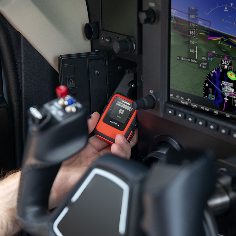
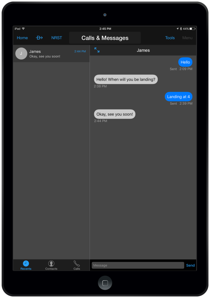
Two-way Communication In-flight
At altitude cellular reception can be nonexistent. It’s locations like these where the inReach devices are designed to keep you connected. With the Iridium satellite network providing global reach, pilots and passengers can send and receive text messages or emails. Additionally, text messages can be sent and received directly within the Garmin Pilot app when paired with a smartphone or tablet, making communicating even easier. Maybe your arrival time has been delayed, or your flight diverted due to weather. Important messages don’t have to wait until you land. Stay in touch globally with inReach.
GPS for Garmin Pilot
Did you know you can leverage the GPS position source within
inReach devices when connected to mobile devices running Garmin Pilot? It’s
just another way the device can integrate into the Connext ecosystem. Connect
the two devices via BLUETOOTH and it can drive a precise georeferenced aircraft
position symbol on your tablet’s moving map display!
Get Help in Case of Emergency
Emergencies situations can happen. They may seldom occur,
but preparation can lead to the best outcomes. inReach devices feature a
dedicated SOS button that alerts GEOS, a professional 24/7 global emergency
monitoring and response coordination center, upon activation. Their trained
staff is available to respond to your messages, track your device and notify
emergency responders in your area – giving you the peace of mind that help is
on the way.
inReach devices require subscriptions for live tracking, messaging and SOS functionality. To learn more about our different inReach devices and subscription plans available, visit Garmin.com/inreach for more information.
*Some jurisdictions regulate or prohibit the use of
satellite communication devices. It is your responsibility to know and follow
all applicable laws in the jurisdictions where the device is intended to be
used.
The post inReach: Everyday Aviation Uses appeared first on Garmin Blog.
https://www.garmin.com/en-US/blog/aviation/inreach-everyday-aviation-uses/