Tag Archives for " Avionics "
GI 275 Ready for Helicopter Installations
The GI 275 electronic flight instrument is ready for installation in select Part 27 Federal Aviation Administration (FAA)-registered helicopters via Field Approval. It has completed stringent helicopter vibration and temperature testing, demonstrating it can withstand the harsh operating environments encountered by helicopters. Initial variants approved for installation include the course deviation indicator (CDI), radar altimeter display and the multi-function display (MFD) versions. Follow-on approval of the GI 275 as a replacement for the attitude indicator and horizontal situation indicator (HSI) via Supplemental Type Certificate (STC) is expected in Q4 2020.
“With these approvals, we’re thrilled to expand the availability of the GI 275 to now include the helicopter market,” said Carl Wolf, vice president of aviation sales and marketing. “The GI 275 is the perfect solution for helicopter owners and operators, as it allows them to take a scalable, cost-conscious approach to their avionics upgrade. Even further, the GI 275 adds a tremendous amount of reliability and capability to any cockpit, making it the perfect upgrade for every panel.”
Lightweight and compact, the GI 275 is intentionally designed to take advantage of the common 3.125-inch flight instrument size, reducing installation time and preserving the existing instrument panel. Its bright, high-resolution touchscreen display and wide viewing angle offers superior readability in the cockpit. In addition to interfacing with the flight instrument via the touchscreen, a dual concentric knob allows pilots to access a variety of key functions. Suitable as a direct replacement to many aging flight instruments, the GI 275 offers operators a simple and straightforward upgrade path to achieve modern flight instrument features and functions.
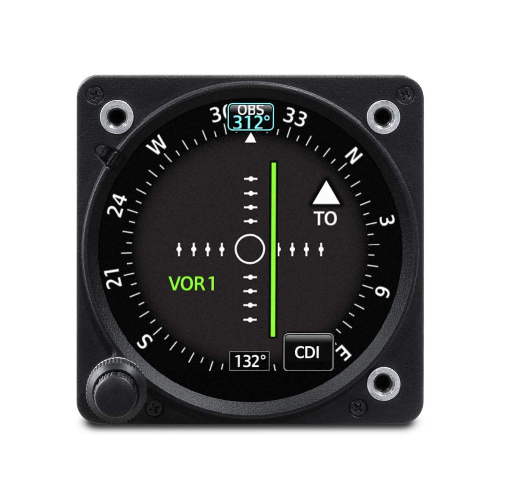
When installed as a CDI, the GI 275 is designed to accept a variety of GPS and navigation inputs, allowing up to two GPS sources and two VHF navigation sources. The GI 275 features an Omni Bearing Resolver that allows the flight instrument to interface to a variety of legacy navigators on the market. Vertical and lateral GPS, VOR/LOC and glide slope deviation can be viewed on the GI 275. When pilots replace an older mechanical CDI, the GI 275 doubles as a modern digital indicator and adds MFD-like capabilities such as a moving map, traffic and weather. MFD-like features add even more capability to the cockpit, including a moving map, MFD flight data, weather, traffic, SafeTaxi® airport diagrams, the display of radar altimeter information and more. The GI 275 can be paired with the GRA® 55/5500 and other third-party products to display radar altimeter data. Visual and aural annunciations are also available.
Built-in Wi-Fi® enables Database Concierge, the wireless transfer of aviation databases to the GI 275. Pilots also have the option to transfer databases to the GI 275 using a USB flash drive and the GSB 15 USB charger. Databases can also be synced among multiple GI 275 flight instruments in a single cockpit. Additional wireless functions include the sharing of GPS position and back-up attitude information with the Garmin Pilot mobile application.
The GI 275 is available immediately for installation via Field Approval in select Part 27 FAA-registered helicopters as a CDI or MFD. Additional features and functions are expected to be approved via STC in Q4 2020. The GI 275 also comes with a two-year warranty and is supported by Garmin’s award-winning aviation support team, which provides 24/7 worldwide technical and warranty support. For additional information, visit www.garmin.com/aviation.
The post GI 275 Ready for Helicopter Installations appeared first on Garmin Blog.
https://www.garmin.com/en-US/blog/aviation/gi-275-ready-for-helicopter-installations/
GI 275: Aircraft Flight Instrumentation Reimagined
Introducing GI 275, a powerful electronic flight instrument that directly replaces legacy primary flight instruments in the cockpit. The GI 275 is suitable as a direct replacement for a variety of instruments including, an attitude indicator, attitude directional indicator (ADI), course deviation indicator (CDI), horizontal situation indicator (HSI) and engine indication system (EIS). Capable of serving as a 4-in-1 flight instrument, the GI 275 can also be installed as a standby to a number of glass flight displays and is available with a 60-minute back-up battery. Lightweight and compact, it is intentionally designed to take advantage of the common 3.125-inch flight instrument size, reducing installation time and preserving the existing aircraft panel. It’s also compatible with a variety of third-party autopilots and does not require a separate interface adapter, further reducing installation labor. The GI 275 has received FAA approval and is available immediately for installation in over 1,000 single-engine and multi-engine aircraft models.
Several variants of the GI 275 are available to meet the needs of over one thousand business and general aviation aircraft models. Features beyond the traditional display of attitude, airspeed and altitude include the option to display CDI, HSI, and engine information. The GI 275 is also capable of displaying multifunction display-like features, such as traffic, weather, terrain, SafeTaxi airport diagrams, optional Synthetic Vision Technology (SVT) and more.
“As constant innovators within the avionics industry, we’re redefining
the aircraft cockpit with the introduction of the GI 275,” said Carl Wolf, vice
president of aviation sales and marketing. “With the GI 275, pilots can
take an economical and scalable approach to their avionics upgrade, while
saving on the installation labor and cost. If it’s round and in their panel,
pilots can likely replace it with the GI 275 to receive modern flight display
features and benefits in a powerful, yet compact touchscreen flight
instrument.”
Suitable as a replacement to many aging flight instruments and
gyro-based attitude indicators on the market such as the popular KI-256, the GI
275 gives aircraft owners the benefits of a modern and reliable flight
instrument. The GI 275 boasts a standard 3.125-inch form factor and rear-mount
design that minimizes panel modification. Its bright, high-resolution touchscreen
display and wide viewing angle offers superior readability in the cockpit. A
dual concentric knob allows pilots to access a variety of key functions within
the flight instrument, such as adjustments to the baro setting or the airspeed
bug. Highly scalable, aircraft owners can start with a single GI 275 and add up
to a total of six in a single panel, paving the way for incremental upgrades
and an array of individualized panel configurations.
Primary attitude indicator
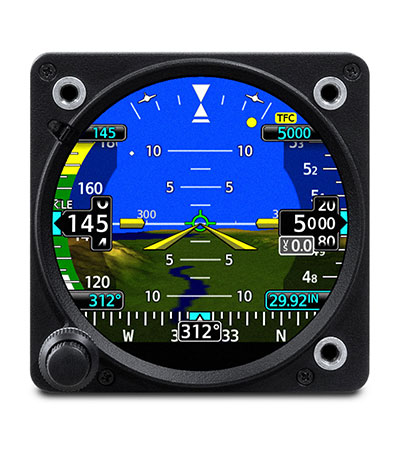
When installed as a primary attitude indicator, the GI 275 offers improved reliability, potential weight savings and reduced maintenance compared to failure-prone vacuum-driven attitude indicators. When the GI 275 serves as primary for attitude information, pilots can also view altitude, airspeed and heading on the instrument. Optional SVT overlays a rich, 3D topographic view of terrain, traffic, obstacles, airport sign posts and more all within the GI 275 attitude display. The GI 275 also overlays a flight path marker within the SVT view, which takes into account crosswind, angle of attack and other factors to show precisely where the aircraft if flying.
The 4-in-1 GI 275 flight instrument is also approved for installation as
a dedicated standby flight instrument to Garmin glass flight displays and is
capable of serving as a back-up to a variety of third-party flight displays on
the market. When installed as a standby to the G500 TXi, the GI 275 is capable
of displaying additional multifunction display features. For back-up navigation
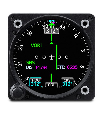
information, a built-in VFR GPS enables convenient direct-to navigation
guidance, displaying aircraft position information on a moving map. In
installations where the GI 275 is installed as a primary or standby flight
instrument, a 60-minute back-up battery is included.
Course Deviation Indicator (CDI) & Horizontal Situation Indicator
(HSI)
When installed as a CDI or HSI, the GI 275 is designed to accept a
variety of GPS or navigation inputs, allowing up to two GPS sources and two VHF
navigation sources. The GI 275 features an Omni Bearing Resolver that allows
the flight instrument to interface to a variety of legacy navigators on the
market without the need for an expensive adapter. With an optional magnetometer,
it is also capable of providing magnetic-based HSI guidance. Vertical and
lateral GPS, VOR/LOC and glide slope deviation can be viewed on the GI 275. CDI
source selection can be accomplished through the touchscreen interface, while
course and heading selection is completed using either the touchscreen or dual
concentric knob. When pilots replace an older mechanical CDI or HSI, the GI 275
doubles as a modern digital indicator and adds MFD-like capabilities such as a
moving map, weather, traffic and terrain.
Suitable as a replacement to display primary engine information
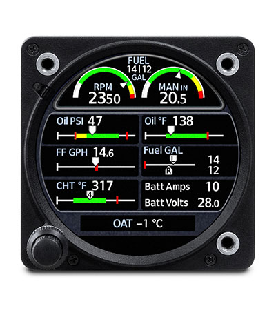
When configured as primary to display engine information, the GI 275 is capable of interfacing with single-engine and multi-engine normally aspirated or turbocharged aircraft with select powerplants, including Lycoming and Continental 4/6-cylinder engines. When the GI 275 replaces mechanical gauges and is configured as primary for engine information, the GI 275 can display RPM, manifold pressure, oil pressure and temperature, cylinder head temperature (CHT), exhaust gas temperature (EGT), turbine inlet temperature (TIT), fuel flow, fuel quantity, fuel pressure, volts and amps. Lean assist functionality is also available so pilots can choose to operate rich of peak or lean of peak. The GI 275 also features exceedance alerting, allowing installers to configure caution and warning alerts per the Pilots Operating Handbook (POH). Advisory alerts such as “high oil temp” or “high CHT” can be configured by the pilot. These exceedances, as well as additional engine data can be shared wirelessly with the Garmin Pilot app on Apple mobile devices and can also be viewed on the flyGarmin website for post-flight analysis. In multi-engine aircraft, dual GI 275’s are required to display engine information.
Multifunction Display
Depending on the configuration and installation, the GI 275 is capable
of displaying additional page functions and features beyond a traditional
flight instrument. These features can include:
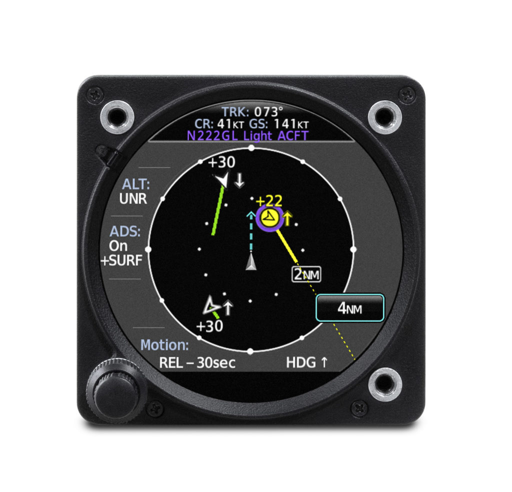
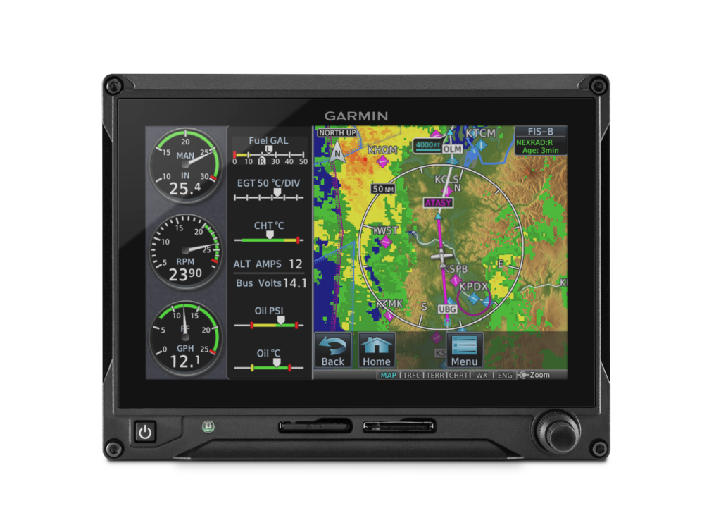
- A multifunction display (MFD) with a moving map can display terrain, obstacles, traffic, weather, airspace information, airways, and more.
- When interfaced to a GTX
 345 or GNX 375, traffic information can be displayed on the dedicated traffic page or moving map. Patented TargetTrend relative motion technology and pop-up traffic alerts further enhance situational awareness.
 - The GI 275 can also be interfaced to a variety of traffic systems, including select Traffic Advisory (TAS) and Traffic Alert and Collision Avoidance Systems (TCAS). Traffic advisories are displayed on the dedicated traffic page and moving map.
- SafeTaxi airport diagrams display runways, taxiways, Fixed Based Operators (FBO’s), hangars and more relative to the aircraft’s location on the airport surface.
- Terrain shading incorporates yellow and red contouring depicting the aircraft is 1,000 and 100 feet above ground level (AGL) respectively. Terrain information, as well as obstacle and WireAware database information can be viewed on the terrain and map pages.
- The GI 275 uses its internal terrain and obstacle database to provide audible and visual terrain proximity alerts, including, “terrain ahead, pull up” and “obstacle ahead, pull up.”
- When paired with the GDL 69 datalink receiver, the GI 275 is capable of displaying SiriusXM Aviation Weather. It can also display Flight Information Service-Broadcast (FIS-B) weather from either a GTX 345 or GNX 375.
- An airport information page displays a variety of information, including frequencies, runway dimensions and more.
- The GI 275 can be paired with the GRA 55/5500 and other third-party products to display a radar altimeter on a dedicated page. Visual and aural annunciations are also available.
- The GI 275 is compatible with the GFC 600 autopilot, as well as an array of third-party autopilots and can replace the primary attitude indicator installed with these autopilots. GFC 500 compatibility is expected later this year.
Built-in Wi-Fi enables Database Concierge, the wireless transfer of aviation databases to the GI 275. Pilots also have the option of transferring databases to the GI 275 using a USB flash drive and the GSB 15 USB charger. Databases can also be synced among multiple GI 275 flight instruments in a single cockpit. When configured to display engine information, the GI 275 can wirelessly send engine data to display within the Garmin Pilot app on Apple mobile devices. This data is also automatically synced and can also be viewed on the flyGarmin website. Wireless flight plan transfer via Bluetooth is available when the GI 275 is paired with a GPS 175, GNC 355 or GNX 375. Additional wireless functions include the sharing of GPS position and back-up attitude information with Garmin Pilot.
The GI 275 is available immediately and is approved for installation in over 1,000 single-engine and multi-engine aircraft models. Select Class IV aircraft are also approved, visit www.garmin.com/GI275 for additional information. Customers can purchase the GI 275 through the Garmin Authorized Dealer network and pricing for various configurations of the GI 275 can be found on the website. A trial period of SVT also comes with the purchase of a GI 275 when it’s configured as an attitude indicator. The GI 275 also comes with a two-year warranty and is supported by our award-winning aviation support team, which provides 24/7 worldwide technical and warranty support. Garmin was awarded top honors last year in avionics product support for the 16th straight year by Aviation International News, and earned the top spot in the annual avionics product support survey conducted by Professional Pilot magazinethis year, also for the 16th consecutive year. For additional information, visit www.garmin.com/aviation.
The post GI 275: Aircraft Flight Instrumentation Reimagined appeared first on Garmin Blog.
https://www.garmin.com/en-US/blog/aviation/gi-275-aircraft-flight-instrumentation-reimagined/
inReach: Everyday Aviation Uses
inReach satellite communication devices* have become a staple for outdoor and marine enthusiasts. Backcountry pilots also find the GPS-equipped, two-way communicators useful for off-the-grid destinations. The built-in interactive SOS feature can provide added peace of mind — not only for adventurers but also their loved ones — knowing that in case of emergency, responders will still be within reach. While inReach devices excel in these unique environments, they definitely aren’t limited to them. Here are some everyday ways pilots, aircraft fleets, and even family members and friends can benefit from inReach devices.
Live Flight Tracking
If the phrase “are we there yet?” causes stress in an
airplane or car, imagine the stress “are they there yet?” can cause
family and friends on the ground. Factor in the possibility you might forget to
send the obligatory “we’ve arrived” text message or phone call —pandemonium can
ensue!
With an inReach device, there’s no need to worry. It can
send track points at preselected time intervals, recorded to a web-based MapShare
trip-sharing page where followers can see your progress and know if you’ve
arrived at your destination. Simply
activate the tracking tool upon departure and share the preset message via text
or email with loved ones — it includes a link to your MapShare page to follow
flight progress. This feature can also come in handy for flight schools to keep
track of student pilots’ flights.

Two-way Communication In-flight
At altitude cellular reception can be nonexistent. It’s locations like these where the inReach devices are designed to keep you connected. With the Iridium satellite network providing global reach, pilots and passengers can send and receive text messages or emails. Additionally, text messages can be sent and received directly within the Garmin Pilot app when paired with a smartphone or tablet, making communicating even easier. Maybe your arrival time has been delayed, or your flight diverted due to weather. Important messages don’t have to wait until you land. Stay in touch globally with inReach.

GPS for Garmin Pilot
Did you know you can leverage the GPS position source within
inReach devices when connected to mobile devices running Garmin Pilot? It’s
just another way the device can integrate into the Connext ecosystem. Connect
the two devices via BLUETOOTH and it can drive a precise georeferenced aircraft
position symbol on your tablet’s moving map display!
Get Help in Case of Emergency
Emergencies situations can happen. They may seldom occur,
but preparation can lead to the best outcomes. inReach devices feature a
dedicated SOS button that alerts GEOS, a professional 24/7 global emergency
monitoring and response coordination center, upon activation. Their trained
staff is available to respond to your messages, track your device and notify
emergency responders in your area – giving you the peace of mind that help is
on the way.
inReach devices require subscriptions for live tracking, messaging and SOS functionality. To learn more about our different inReach devices and subscription plans available, visit Garmin.com/inreach for more information.
*Some jurisdictions regulate or prohibit the use of
satellite communication devices. It is your responsibility to know and follow
all applicable laws in the jurisdictions where the device is intended to be
used.
The post inReach: Everyday Aviation Uses appeared first on Garmin Blog.
https://www.garmin.com/en-US/blog/aviation/inreach-everyday-aviation-uses/

TXi Flight Displays, GTN Navigators, GFC Autopilots and G5 Electronic Flight Instrument Updates
We are adding significant capability, more configuration options and offering greater integration throughout the GTN 650/750 touchscreen navigators, the G500 TXi/G600 TXi and G500/G600 flight displays, as well as the GFC 600 & GFC 500 autopilots. Additionally, the G5 electronic flight instrument for certificated aircraft is being approved for use as a standby instrument when paired with the G500 TXi or G500 flight displays. The GFC 500 autopilot will also be approved for installation with the G500 TXi or G500 flight displays, while the addition of descent vertical navigation (VNAV) within the GTN will aid in descent planning. With Garmin, pilots receive a seamlessly integrated cockpit that offers a more harmonious transition among avionics, which reduces pilot workload and provides a superior in-flight experience.
“The Garmin avionics ecosystem continues to provide pilots with optimized upgrade opportunities and unsurpassed capabilities within the cockpit,” said Carl Wolf, vice president of aviation marketing and sales. “We are committed to providing pilots with scalable, value-oriented solutions when selecting their panel configurations. For customers with these products currently installed, these software updates offer greater operational potential and a broader feature set than any other avionics solution on the market.”
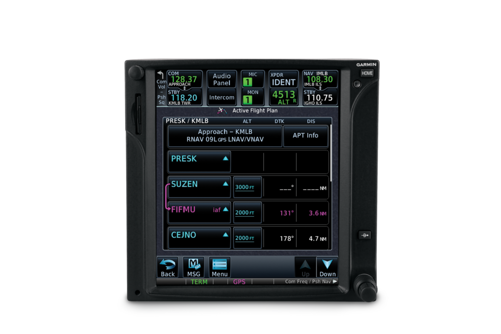
GTN 650/750 descent vertical navigation
To assist in descent planning and energy management, pilots can take advantage of VNAV profiles throughout the enroute and terminal phases of flight within the GTN 650/750 touchscreen navigators when they’re paired with the G500 TXi/G600 TXi, G500/G600 or G5. Within the GTN, pilots can easily enter altitude constraints on the flight plan page to set-up a vertical descent profile. Pilots also experience a near-seamless transition from VNAV to an arrival and instrument approach. Once an arrival or approach is loaded and activated, the GTN automatically populates step-down altitudes or any applicable altitude restrictions. If ATC issues an unpublished altitude restriction, pilots can enter those altitudes manually into the active flight plan under the VNAV field.
As part of the VNAV profile, top of descent (TOD) and bottom of descent (BOD) values are also calculated and displayed on the moving map. As the aircraft arrives at TOD, the GTN displays a visual annunciation prompting the pilot to begin the descent. When paired with a display such as a
G500 TXi/G600 TXi, G500/G600 or G5, a vertical deviation indication (VDI) also populates on the display to provide vertical guidance for the descent. Additionally, when the GTN 650/750 series is paired with the GFC 600 or GFC 500 autopilot, pilots can select the VNAV button on the mode controller to fly a fully- coupled VNAV profile.
GTN 750
Approved as a standby: G5 electronic flight instrument
Our ever-popular G5 electronic flight instrument will soon be approved as a standby flight instrument when paired with the G500 TXi or G500 flight displays. In doing so, any adjustments made to heading bugs, altitude select, airspeed bugs, as well as the barometric pressure setting are automatically synced from the G500 TXi or G500 displays to the G5. Flight director and autopilot mode annunciations from the GFC 500 can also be viewed across all displays, including G5. Over 600 aircraft will be approved for the installation of G5 as a standby flight instrument alongside the G500 TXi or G500 flight displays.
GFC 500: Now approved for G500 TXi and G500-equipped aircraft
Aircraft owners can soon pair the economical GFC 500 autopilot with the G500 TXi or G500 flight displays, offering a fully-redundant, all-glass cockpit when paired with the G5. For example, in the unlikely event of a G500 TXi flight display failure, the G5 will remain coupled to the GFC 500 autopilot and continue to fly normal autopilot modes, including altitude select, heading, vertical speed and more. This compatibility significantly reduces pilot workload.
Course deviation indication (CDI) and VDI preview
A popular feature in turbine class aircraft, a CDI preview option allows pilots to view course and vertical deviation information prior to an instrument approach. When the GTN series is paired with the
G500 TXi/G600 TXi or G500/G600, pilots can view this feature within the HSI or lateral deviation indicator on the flight display. When GPS is the selected CDI source, information such as a course pointer, lateral deviation, station ID and the numeric inbound course automatically populate on the HSI in gray when an instrument approach is loaded. For ILS and GPS approaches with vertical guidance, a preview of the VDI also populates on the TXi series, G500/G600 or G5, allowing pilots to view glideslope or glidepath deviation prior to the descent.
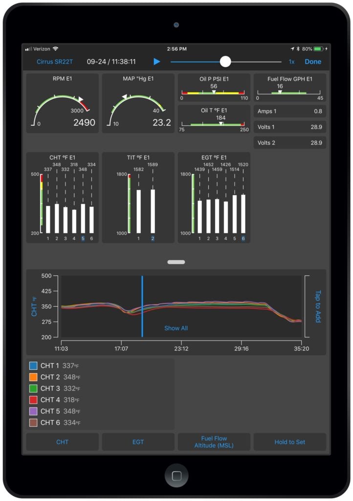
Garmin Pilot and Engine Information System (EIS) analytics
Exclusive to Garmin, customers can now utilize Garmin Pilot on Apple mobile devices to view real-time engine information via Flight Stream 510 when the app is paired with an EIS-capable TXi flight display or the G1000 NXi integrated flight deck. Upon landing, the flight data log is wirelessly uploaded to the flyGarmin website and is stored securely within the app and on flyGarmin. Within the flyGarmin website, pilots can access detailed information related to any flight, play-back the flight and download data logs.
Garmin Pilot EIS on iOS
New TXi display orientations, configurations and capabilities
The TXi family adds even more options, such as:
- The 10-inch TXi flight display can be configured to a 40% PFD and 60% MFD split-screen layout.
- On a 7-inch portrait or landscape G500 TXi/G600 TXi, the displays can be configured to view moving map and single-engine information simultaneously.
- The 7-inch landscape TXi display can be used as a PFD, adding installation flexibility in aircraft panels that are space-limited.
- With a compatible camera, pilots can optionally display multiple video inputs on the MFD of a TXi display.
- Within EIS-capable TXi displays, pilots can select and view individual cylinder head temperature (CHT) values.
G500 TXi
GTN 650/750 series enhancements
The GTN 650/750 touchscreen navigators also incorporate a variety of additional features, including:
- The addition of new audible and visual terrain proximity alerts, including, “terrain ahead, pull up”, “obstacle ahead, pull up” and “wire ahead.” An aural “five-hundred” annunciation is also available when the aircraft is on approach to land.
- Pilots can now set a user-defined waypoint as an airport so terrain alerts are minimized while landing at an airport that is not in the aviation database.
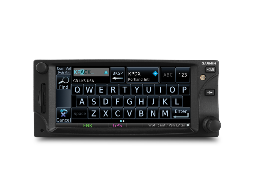
- The addition of a QWERTY keyboard within the GTN 650/750 and the G500 TXi/G600 TXi gives pilots a more familiar way to input information.
- Pilots can configure COMM sidetone settings within the GTN series.
- Irish, Swiss and English coordinate systems are now supported so it’s easier for pilots to enter GPS coordinates in various formats, including latitude/longitude, degrees/minutes/seconds and decimal degrees.
- The new GWX 75 weather radar is now supported by the GTN touchscreen navigators and the G500 TXi/G600 TXi flight displays, which offers four-times more color contouring than typically found on other weather radars on the market.
GTN 650
These software updates are available from Garmin Authorized Dealers for hundreds of aircraft makes and models, at no charge (dealer installation charge may apply). Our avionics are supported by our award-winning aviation support team, which provides 24/7 worldwide technical and warranty support. For additional information, visit www.garmin.com/aviation.