Tag Archives for " Avionics "
FLYING Magazine Honors Garmin Autoland with Editors’ Choice Award
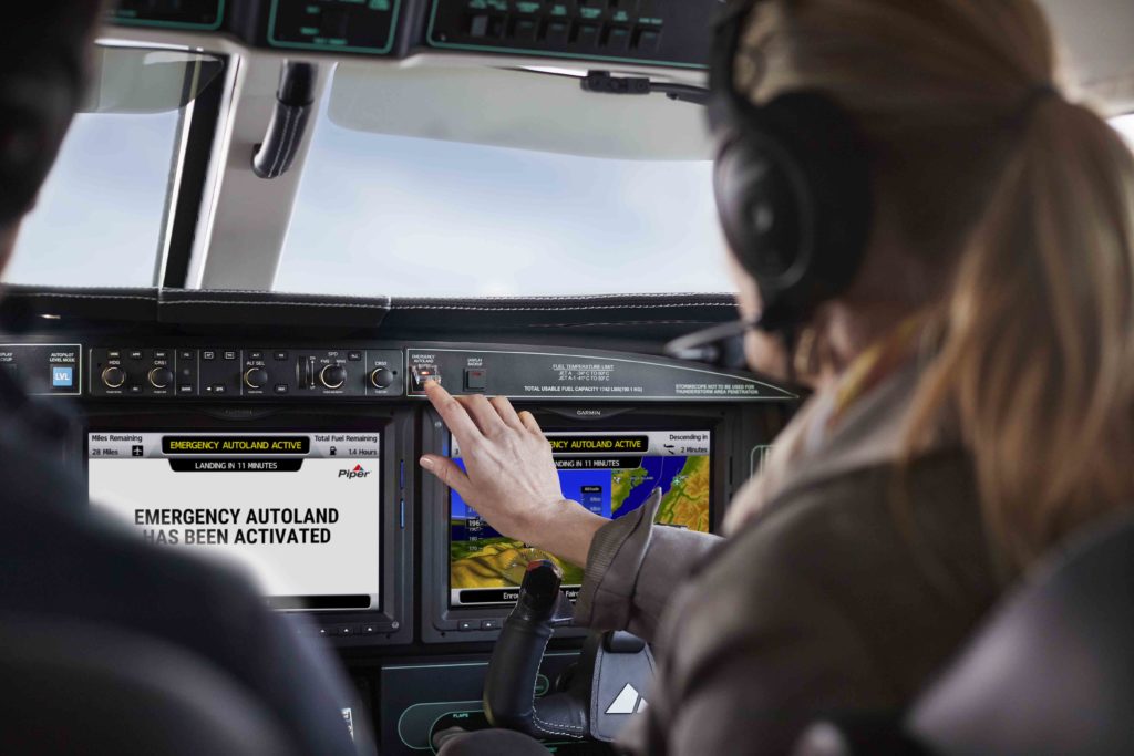
FLYING Magazine honored our revolutionary Autoland system — part of our Garmin AutonomiTM family of autonomous safety-enhancing technologies — with a 2021 Editors’ Choice Award. Autoland is the world’s first certified system of its kind with the ability to activate during an emergency situation to autonomously control and land an aircraft without human intervention1.
Each year, FLYING’s Editors’ Choice Awards celebrate an elite collection of aircraft and products that demonstrate significant innovation and technological advancements. For 2021, FLYING chose to honor the collaboration between organizations in the efforts required to achieve certification well as highlighting the importance of working together to drive innovation forward for the industry.
“We are humbled to receive this award for Autoland from such a revered publication like FLYING,” said Carl Wolf, Garmin vice president aviation sales and marketing. “This award recognizes a decade’s worth of passion and dedication exhibited by the Garmin team who never stop innovating in ways that help make aviation safer. Even more, we are proud to receive this recognition along with our aircraft manufacturing collaborators Piper, DAHER, and Cirrus, who shared the same vision to bring this life- saving technology to the industry.”
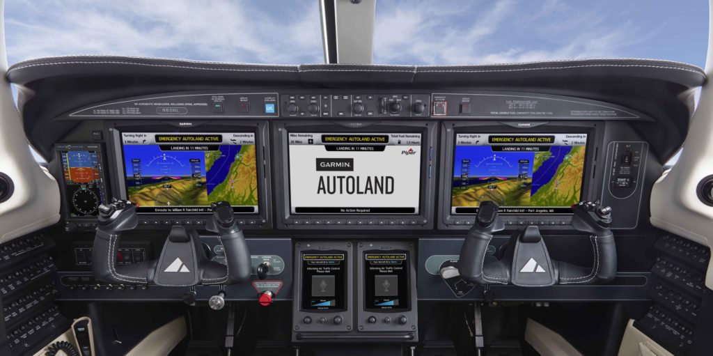
In the event of an emergency such as pilot incapacitation, the pilot or even a passenger on board can activate Autoland to land the aircraft with a simple press of a dedicated button. Autoland can also activate automatically if the system determines it’s necessary. Once activated, the system immediately calculates a flight path to the most suitable airport and runway, while avoiding terrain and adverse weather, initiates an approach and automatically lands the aircraft.
This year’s recipients of FLYING’s Editors’ Choice Awards will compete for the FLYING 2021 Innovation Award, an honor presented in conjunction with EAA AirVenture, July 26 through August 1, recognizing the most innovative product to have reached the business and general aviation market the previous year.
The first Autoland system for general aviation aircraft, Garmin Autoland has received Federal Aviation Administration (FAA) certification in the Piper M600, the Daher TBM 940, and the Cirrus Vision Jet as part of the G3000® integrated flight deck. European Union Aviation Safety Agency (EASA) approval was also granted to Daher with the TBM 940.
For additional information about Autoland and the Garmin AutonomiTM family of automated flight technologies, visit www.garmin.com/Autonomi.
The post FLYING Magazine Honors Garmin Autoland with Editors’ Choice Award appeared first on Garmin Blog.
https://www.garmin.com/en-US/blog/aviation/garmin-autoland-wins-flying-magazine-editors-choice-award/
Garmin Pilot Training Team Expands 2021 Opportunities
Our pilot training team is offering expanded pilot training opportunities for 2021, including virtual training options through June 2021 and plans for the resumption of in-person training starting in August. A variety of opportunities are available ranging from self-study materials, webinars, eLearning courses and instructor-led training offered for the GTN Series, G500/G600, G500/600/G700 TXi, G3X Touch, and Garmin integrated flight decks. Our instructor-led courses provide pilots with a hands-on approach to learning Garmin avionics in a virtual or in-person classroom environment taught by a team of dedicated and experienced flight instructors.
Professional instructor-led training
In the fall of 2021, our aviation training team intends to resume classroom training offered for all levels of experience at our headquarters in Olathe, Kansas assuming COVID-19 protocols can be safely followed. The health and safety of our customers and associates remains paramount to Garmin. We will continue to monitor the situation and communicate options to all registered attendees in advance if the current situation continues into the fall. To see the full calendar of training events and information on purchasing these classes, please visit www.fly.garmin.com/training.
- GTN Series: Explore the capabilities that Garmin’s GTN and GTN Xi series of navigators provides in this one-day virtual training class, or two-day in-person classroom training. This class is intended for both novice and experienced aviators using scenario-based training that builds on knowledge obtained through the GTN 2.0 eLearning course. The cost to attend the virtual GTN training class is $495, and the cost for the in-person classroom training is $550.
- GTN and Flight Display: This one-day virtual training class, or two-day in-person classroom training, includes instruction on the GTN/GTN Xi navigators and TXi series, G3X Touch and the G500/G600 displays. The training focuses on flight planning and instrument procedures for those that are both new to the GTN or just looking for a refresher, building on knowledge obtained through the GTN 2.0 eLearning course. The cost for the virtual training class is $625, and the cost for the in-person classroom training is $700.
- G1000®/G1000 NXi: With an emphasis on flight planning, instrument procedures, vertical navigation, and the automatic flight control system, this one-day instructor-led virtual training class, or two-day in-person classroom training, explores the vast capabilities of the G1000 integrated flight deck, building on knowledge obtained through G1000 NXi eLearning course. The cost for this virtual course is $700, and the cost for in-person classroom training is $825.

Take full advantage of Garmin avionics features and capabilities with eLearning Courses
Pilots can receive in-depth instruction to better prepare for flights through eLearning courses that guide them through scenarios intended to build understanding and confidence with Garmin avionics. Using a computer, tablet or smartphone, pilots can access the courseware immediately through the eLearning platform. Garmin eLearning courses come with a two-year subscription and can be purchased at www.fly.garmin.com/training.
The following eLearning opportunities are available:
- Garmin GTN Essentials 2.0: This course provides in-depth instruction on the fundamental operation of the highly capable GTN and GTN Xi touchscreen navigators, as well as helicopter features, for pilots that are new to the GTN or just want a refresher.
- Garmin TXi Essentials: For pilots that are new to the system, this course will provide instruction on fundamental operation of the touchscreen flight display.
- Garmin G1000 NXi: Pilots will have four comprehensive courses to choose from that will provide in-depth training on the G1000 NXi depending on the needs of the pilot to enable effective use of the system’s situational awareness and decision-making resources.
- Garmin G3000® Essentials: This eLearning course introduces pilots to the operation and user interface of the G3000 integrated flight deck.
- Garmin G5000® Essentials 2.0 and 2.0 PLUS: Introduces pilots to the operation and user interface of the G5000 integrated flight deck, including the latest features. The G5000 Essentials 2.0 PLUS course includes a separate module that describes autothrottle usage.
- Garmin Aviation Weather Radar 2.0: This course helps pilots understand the fundamentals of weather radar and the latest features to take full advantage of Garmin GWX systems.
Attend monthly one-hour webinars
These scenario-based webinars are offered monthly for no charge and are intended to help pilots explore various avionics setups, flight planning, navigation and other features with Garmin pilot instructors. Webinar options are updated monthly, so please be sure to check back frequently for the latest offerings. To register for Aviation Webinars, please visit Garmin.com/AviationWebinars.

EAA AirVenture 2021
The Garmin Aviation Training team anticipates offering seminars and classes at EAA AirVenture. The team plans to provide two-hour GTN Series training seminars from July 26-30, focusing on what is most important to customers – flight planning and instrument approach procedures. We will also offer the G3X Touch Academy and other GTN pilot training seminars in the Garmin tents. As EAA AirVenture 2021 nears, visit flyGarmin.com/training to see the full and evolving list of training events and to registers for one of these classes.
Build a solid foundation with self-study opportunities
Detailed pilot guides provide extensive information on features, functions, and capabilities related to Garmin avionics that the pilot must know in order to operate the aircraft. Free pilot guides are available for download for all retrofit installations including the GTN series, GTN Xi series, G500/G600, G500/G600/G700 TXi, and G3X Touch. For integrated flight decks such as the G1000, G3000 and G5000, the pilot’s guides are available from the aircraft manufacturer. Training videos and pilot training webinar recordings can be found on the Garmin Aviation YouTube channel.
PC and iPad® Trainers
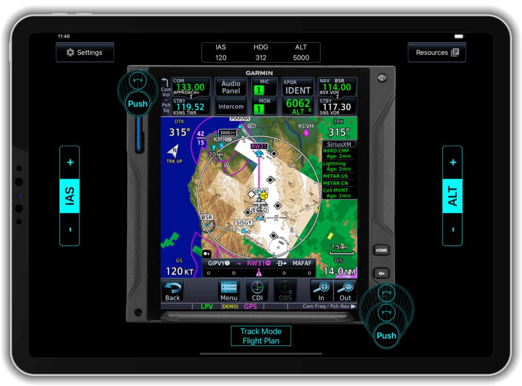
We also offers a limited number of computer (PC) and iPad trainers that simulate the behavior of an avionics system interface for pilots interested in learning the basic operation of a system. Current PC trainers can be found at www.Garmin.com, and the GTN, GTN Xi, and TXi series trainer apps are available for download from the Apple® App Store®.
Custom Training Requests
The Garmin Aviation Training team can support on-demand training requests based upon instructor availability and training resource considerations on a first-come, first serve basis. For all Garmin aviation training needs, including reservations for one of these training events, please visit www.fly.garmin.com/training. For additional information, please contact aviation.training@garmin.com.
The post Garmin Pilot Training Team Expands 2021 Opportunities appeared first on Garmin Blog.
https://www.garmin.com/en-US/blog/aviation/garmin-pilot-training-team-expands-2021-opportunities/
Garmin GI 275 Electronic Flight Instrument Receives EASA Approval
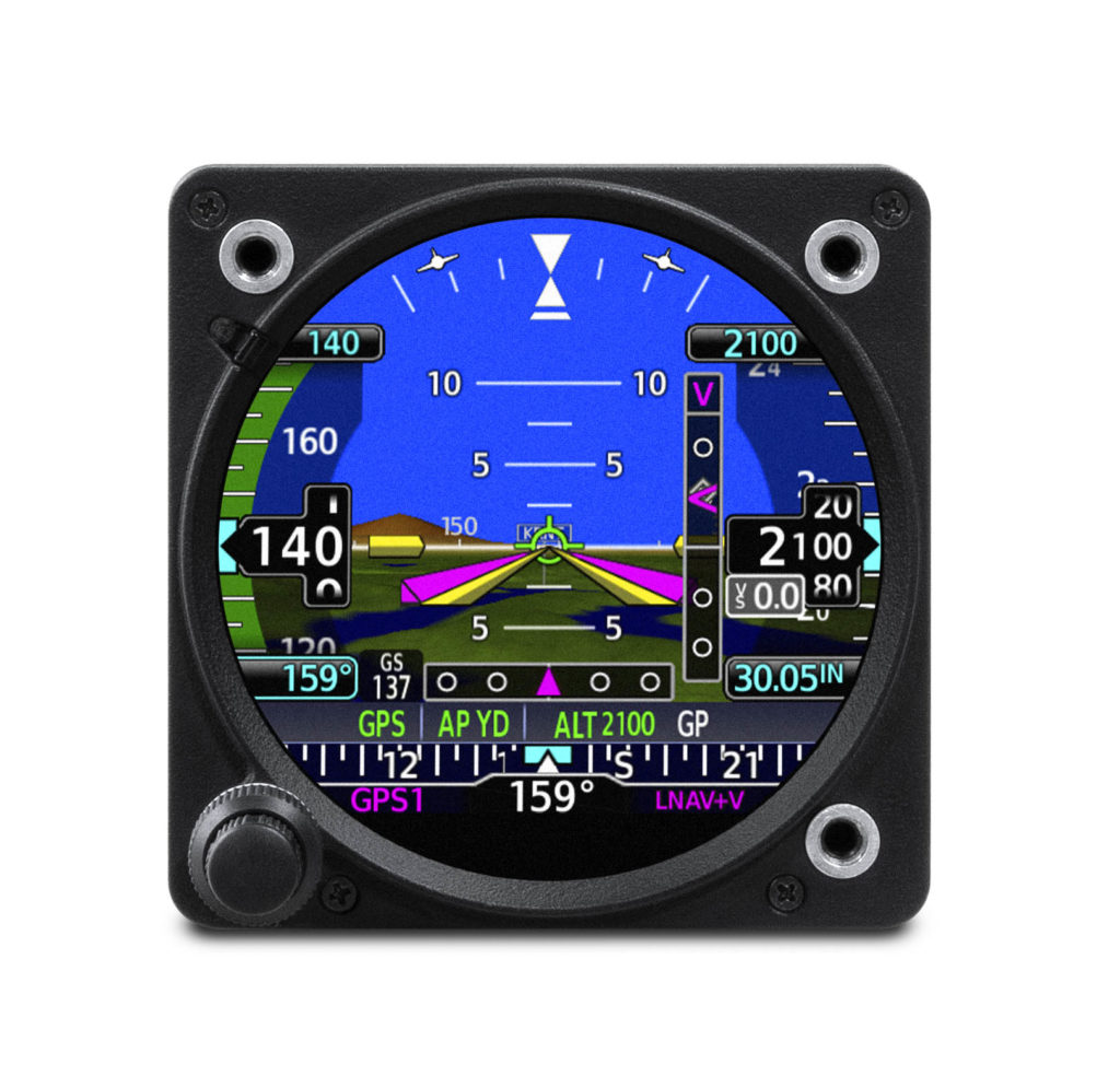
Our popular GI 275 electronic flight instrument has received European Union Aviation Safety Agency (EASA) approval, allowing installation in over 1,000 single-engine and multi-engine aircraft models. Several variants of the GI 275 are now available to meet the needs of business and general aviation aircraft. A powerful electronic flight instrument, the GI 275 is suitable as a direct replacement for a variety of legacy primary flight instruments in the cockpit such as the attitude indicator, attitude-direction indicator (ADI), course deviation indicator (CDI), horizontal situation indicator (HSI), multi-function display (MFD), and engine indication system (EIS). In addition, the GI 275 can also be installed as a standby attitude indicator when paired with large format electronic flight displays.
“Garmin worked closely with EASA to bring the popular GI 275 to thousands more cockpits with aging flight instruments,” said Carl Wolf, vice president of aviation sales and marketing. “With this approval, the modern GI 275 electronic flight instrument gives pilots the opportunity to take an economical and scalable approach to their avionics upgrade while realizing tremendous potential with the extraordinary capability of the versatile touchscreen GI 275.”
Lightweight and compact, the GI 275 is a reliable flight instrument intentionally designed to take advantage of the common 3.125-inch flight instrument size, reducing installation time and preserving the existing aircraft panel. Its bright, high-resolution touchscreen display and wide viewing angle offers superior readability in the cockpit. A dual concentric knob allows pilots to access a variety of key functions within the flight instrument, such as adjustments to the baro setting or the airspeed bug. Highly scalable, aircraft owners can start with a single GI 275 and add up to a total of six in a single panel, paving the way for incremental upgrades and an array of individualized panel configurations.
Primary and standby attitude indicator
When installed as a primary attitude indicator, the GI 275 offers improved reliability, potential weight savings and reduced maintenance compared to less reliable, vacuum-driven attitude indicators. When the GI 275 serves as primary for attitude information, pilots can also view altitude, airspeed and heading1 on the instrument. Optional Synthetic Vision Technology overlays a rich, 3D topographic view of terrain, traffic, obstacles, airport signposts and more, all within the GI 275 attitude display2.Additional features include the display of outside air temperature, groundspeed, as well as true airspeed and wind information on the attitude indicator.
The GI 275 flight instrument is also approved for installation as a dedicated standby flight instrument to Garmin glass flight displays and is capable of serving as a back-up to a variety of third-party flight displays on the market. When installed as a standby flight instrument to the G500 TXi, the GI 275 is capable of displaying additional multifunction display features. In installations where the GI 275 is installed as a primary or standby flight instrument, a 60-minute back-up battery is included.
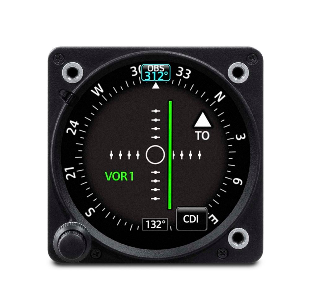
Course Deviation Indicator (CDI) & Horizontal Situation Indicator (HSI)
When installed as a CDI or HSI, the GI 275 is designed to accept a variety of GPS and navigation inputs, allowing up to two GPS sources and two VHF navigation sources. The GI 275 features an Omni Bearing Resolver that allows the flight instrument to interface to a variety of legacy navigators on the market without the need for an expensive adapter. With an optional magnetometer, it is also capable of providing magnetic-based HSI guidance. Selecting the CDI source is simple and can be accomplished through the touchscreen interface, while course and heading selection is completed using either the touchscreen or dual concentric knob. When aircraft owners replace an older mechanical CDI or HSI, the GI 275 doubles as a modern digital indicator and adds MFD-like capabilities such as a moving map, weather, traffic and terrain.
Autopilot compatibility with the GI 275
A single GI 2753 electronic flight instrument can be used as the attitude source to drive the GFC 500 autopilot, while also displaying mode annunciations and flight director indications. For added redundancy in aircraft equipped with a dual GI 275 installation, the secondary GI 2753 is capable of coupling to the GFC 500 autopilot, as well. In the unlikely event of a primary GI 275 failure, the autopilot remains fully functional when paired with the secondary GI 275. Additional redundancy is extended to include the G500 TXi & G600 TXi flight displays, which also allow the GI 275 to couple to the GFC 500 autopilot if needed when serving as a standby instrument. Unique to the GI 275 and TXi, pilots will receive a mis-compare annunciation if the AHRS sources between the two do not align. GI 275 is also compatible with the GFC 600 digital autopilot, as well as a variety of third-party autopilots and does not require a separate interface adapter, further reducing overall cost and installation labor. The GI 275 can replace the primary attitude indicator installed with these autopilots.
Additional capabilities
Depending on the configuration and installation, the GI 275 is capable of displaying additional page functions and features beyond a traditional flight instrument. These features can include:
- A multifunction display (MFD) with a moving map can display terrain, obstacles, traffic, weather, airspace information, airways, and more.
- When interfaced to a GTX 345 or GNX 375, traffic information can be displayed on the dedicated traffic page or moving map. Patented TargetTrend relative motion technology and pop-up traffic alerts further enhance situational awareness.
- The GI 275 can also be interfaced to a variety of traffic systems, including select Traffic Advisory (TAS) and Traffic Alert and Collision Avoidance Systems (TCAS). Traffic advisories are displayed on the dedicated traffic page and moving map.
- SafeTaxi airport diagrams display runways, taxiways, Fixed Based Operators (FBO’s), hangars and more relative to the aircraft’s location on the airport surface.
- Terrain shading incorporates yellow and red contouring depicting the aircraft is 1,000 and 100 feet above ground level (AGL) respectively. Terrain and obstacle information can be viewed on the terrain and map pages.
- The GI 275 uses its internal terrain and obstacle database to provide audible and visual terrain proximity alerts, including, “terrain ahead, pull up” and “obstacle ahead, pull up.”
- Engine information system with optional interface module and GEA 110 sensor has the ability to serve as a primary EIS display for piston engine, fuel, electrical and other data. Dual GI 275 flight instrument installations are able to display engine information for twin-engine aircraft.
- An airport information page displays a variety of data, including frequencies, runway dimensions and more.
- The GI 275 can be paired with the GRA 55/5500 and other third-party products to display radar altimeter on a dedicated page. Visual and aural annunciations are also available.
Built-in Wi-Fi enables Garmin’s Database Concierge, the wireless transfer of aviation databases to the GI 275. Pilots also have the option of transferring databases to the GI 275 using a USB flash drive and the GSB 15 USB charger. Databases can also be synced among multiple GI 275 flight instruments in a single cockpit. When configured to display engine information, the GI 275 can wirelessly send engine data to display within the Garmin Pilot app on Apple mobile devices. This data is also automatically synced and can also be viewed and stored on the flyGarmin website. Wireless flight plan transfer via Bluetooth is available when the GI 275 is paired with a GPS 175, GNC 355 or GNX 375. Additional wireless functions include the sharing of GPS position and back-up attitude information with Garmin Pilot.
The GI 275 is available immediately and approved for installation in over 1,000 single-engine and multi-engine aircraft models. Select Class IV aircraft also are approved; visit www.garmin.com/GI275 for additional information. For full installation details, and to purchase the GI 275, contact a Garmin Authorized Dealer. A trial period of SVT also comes with the purchase of a GI 275 when it’s configured as an attitude indicator. The GI 275 also comes with a two-year warranty and is supported by our award-winning aviation support team, which provides 24/7 worldwide technical and warranty support. For the 17th consecutive year, both Aviation International News and Professional Pilot magazine, two predominant aviation publications, awarded the Garmin aviation support team top honors for avionics product support. For additional information, visit www.garmin.com/aviation.
- Requires an optional magnetometer
- Features and functions depend on configuration and variant selected, visit a Garmin Authorized Dealer for additional information.
- Requires GI 275 ADAHRS variant.
The post Garmin GI 275 Electronic Flight Instrument Receives EASA Approval appeared first on Garmin Blog.
https://www.garmin.com/en-US/blog/aviation/garmin-gi-275-electronic-flight-instrument-receives-easa-approval/
TXi Touchpoint: Not Your Average HSI
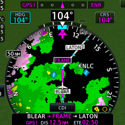
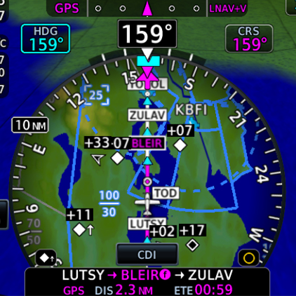
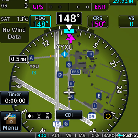
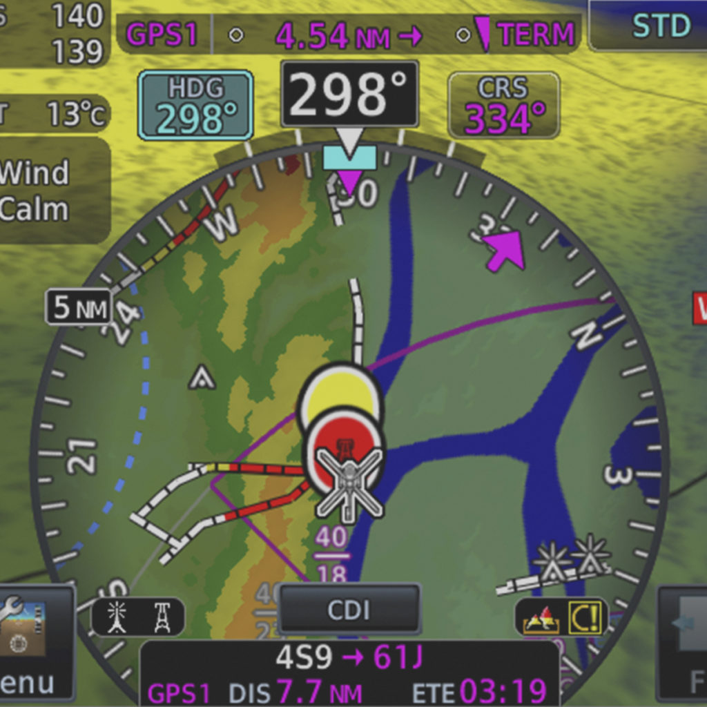
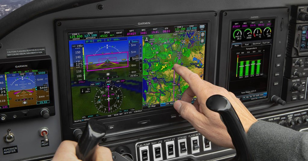
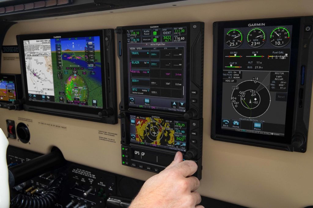
The horizontal situation indicator (HSI) commands a significant portion of a pilot’s attention throughout a flight, especially during instrument procedures. Your focus and attention are balanced between various instruments, processing information and deciphering data as you make decisions in the cockpit. A primary flight display that can concentrate this critical information within pilots’ primary field of view could help reduce workload and streamline actions during these critical phases of flight. We took this into consideration with our TXi flight display series and developed an HSI mapping feature that provides not only traditional heading information and course guidance, but also additional data overlays to enhance pilots’ situational awareness. This touch-interface, MFD-like map can present NEXRAD imagery and weather, as well as SafeTaxi® diagrams, traffic, terrain alerting and more.
Better understand the weather around you
The TXi HSI map can overlay SiriusXM® Aviation Satellite Weather, ADS-B datalink weather or Doppler Radar, providing a better understanding of conditions and how they relate to your current position. For an added layer of weather information, Stormscope®, cell data and lightning strike information also can be viewed within the HSI map. Plus, it’s easy to zoom in for a closer look or zoom out for a ”higher-level” view of the conditions, simply swipe your finger up and down on the touchscreen HSI display.
ADS-B traffic targets
Also, keep an eye on surrounding ADS-B-equipped traffic. On aircraft properly equipped with select ADS-B solutions and a TXi series flight display, this dual-link position tracking feature allows you to see where an aircraft target is with respect to your own aircraft’s position within the HSI map. If a target gets too close, it changes to a highlighted yellow icon for added awareness.
Terrain alerting
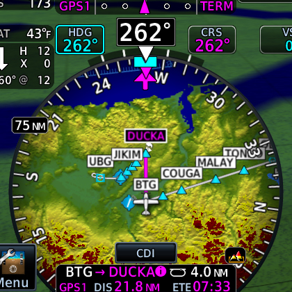
Hazardous terrain up ahead? The TXi HSI map presents the surrounding landscape in shades of green, yellow and red — from lowest risk to highest risk, respectively. If you’re approaching dangerous terrain, an alert will indicate the close proximity, helping the aircraft remain clear of hazards and on course.
Obstacles awareness
Stay apprised of obstacles along your flight path, like towers and buildings, while staying on course. Like terrain alerting, obstacles are displayed by degree of hazard — white indicating “no factor,” yellow to “be cautious” and red representing “danger.” As you approach dangerous obstacles, the indications become more distinct and pronounced, alerting pilots to take corrective action if necessary.
SafeTaxi airport navigation
We created SafeTaxi to help pilots navigate airports more easily. This tool displays a geo-referenced airport diagram and displays runways, taxiways and hangars relative to an aircraft’s location on the field. It also identifies hold short lines, providing pilots an even greater level of awareness to their location within the terminal environment.
WireAware and HTAWS for Helicopters
Helicopter pilots can benefit from the TXi HSI map too. Our G500H TXi for helicopters combines our WireAware wire-strike avoidance technology with optional HTAWS (Helicopter Terrain Awareness and Warning System) data to provide a comprehensive solution. It can help identify dangerous terrain and hazardous obstacle transmission (HOT) lines for the U.S. as well as some locations in Canada and Mexico.
In addition to TXi series flight displays, select HSI mapping features and functions are available with G1000® NXi, G3000® and G5000® integrated flight decks, as well as our GI 275 electronic flight instrument. To learn more about our HSI map, and all of our safety-enhancing aviation solutions, visit Garmin.com/aviation.
Sirius, XM and all related marks and logos are trademarks of Sirius XM Radio Inc.
Stormscope is a registered trademark of L-3 Communications.
The post TXi Touchpoint: Not Your Average HSI appeared first on Garmin Blog.
https://www.garmin.com/en-US/blog/aviation/txi-touchpoint-not-your-average-hsi/
New Safety-Enhancing Features for GTN Xi Series Navigators
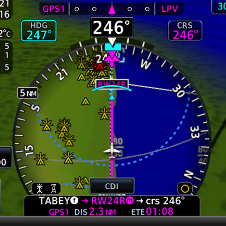
Our GTN Xi Series of navigators now feature even more advanced capabilities, including a Glide Range Ring that helps safety-minded pilots visualize the estimated area an aircraft could reach in the case engine power is lost1. Other new features include the ability to remotely control the radios of another GTN Xi when dual GTN Xi units are installed in an aircraft, quicker page navigation with the addition of customizable dual concentric knob functions, and more.
Glide Range Ring
The new Glide Range Ring helps pilots enhance their situational awareness by depicting the estimated area that the aircraft can reach when it’s configured for best glide range in the case of an engine failure. It considers terrain data, as well as wind data when provided by a GDL 69 or FIS-B Source, or calculated winds from a compatible Garmin fight display2, in order to help pilots continuously plan while flying. Further, G500 TXi or G600 TXi flight displays can also show the Glide Range Ring when paired with the GTN Xi while using the GTN Xi GPS guidance as the horizontal situational indicator (HSI) source.
Best Glide Airport Indicator
Depicted as cyan chevrons pointing to the recommended airport for the aircraft to glide to from its current position, the Best Glide Airport Indicator1 is selected based upon distance from present location, runway length at the airport, wind data, and airport weather through FIS-B or Sirius XM if available on the aircraft. If desired, the Best Glide Airport Indicator can be displayed by itself or with the Glide Range Ring also shown.
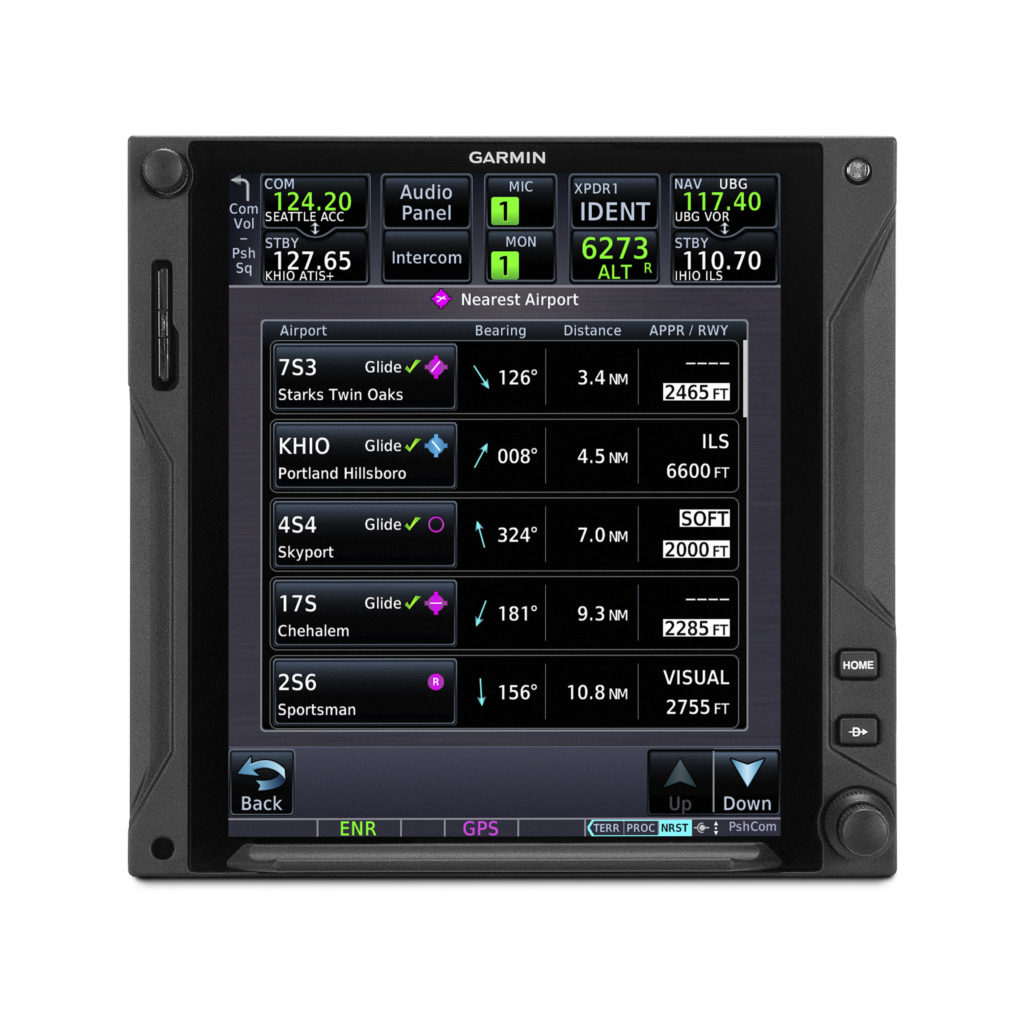
Nearest Airport list updated to show Glide Check
The Nearest Airport list now indicates which airports are estimated to be reachable on glide by displaying a green check mark indication next to the airport identifier1. If the pilot’s criteria for nearest airports would have excluded an airport that is estimated to be within glide range, the system will automatically add these airports back to the Nearest Airport list and display the Glide Check, while also highlighting the runway length and surface type with a white box if these figures do not meet the previous nearest airport criteria set by the pilot.
Remote radio control and new radios page
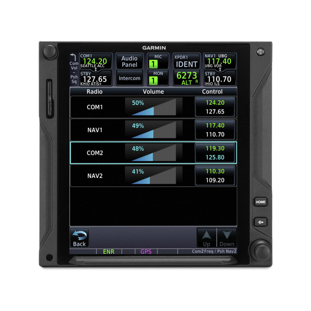
When dual GTN Xi navigators are installed, pilots can now remotely control and tune the radio frequencies on both units from a single GTN Xi navigator. Pilots can control both the Comm and Nav radio tuning, in addition to volume level, which is an especially useful function for quick radio tuning in a busy flight environment. Additionally, pilots can cycle through radios of both GTN Xi navigators by pressing the dual concentric knob on just one GTN Xi. A new radios page displays all Comm and Nav frequencies (active and standby) of both units, as well as volume levels. The radios page can be quickly accessed from the frequency keypad page or as a preset user field button. From this page, pilots can easily flip the respective active and standby frequencies. Also new, pilots can load a frequency to the active or standby position of either GTN Xi from applicable airport or waypoint information pages.
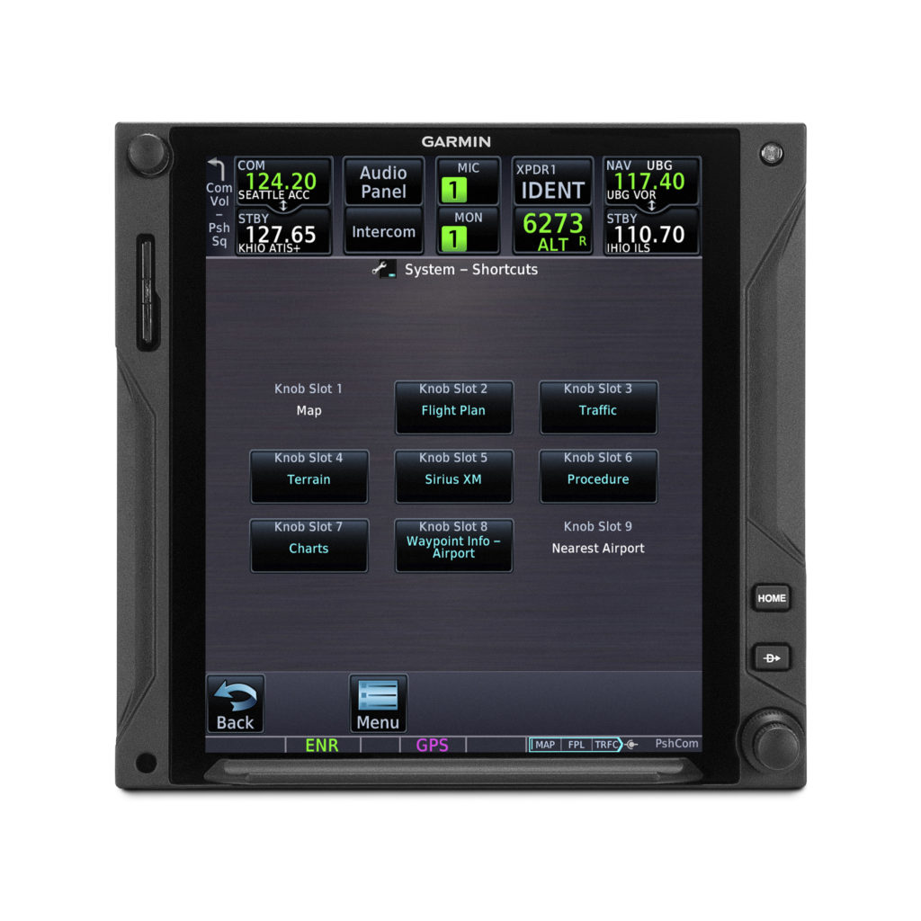
Quicker page navigation with dual concentric knob
Similar to other Garmin navigators, the dual concentric knob can now enable quicker access to select pages. The outer knob now allows the pilot to intuitively cycle between pages on their GTN Xi, while the inner knob can now support functionality related to the current page being displayed, such as scrolling through lists or zooming in on maps. A new locator bar works in conjunction with the outer knob and indicates the current page while also displaying which page is next. Pilots can allocate and customize up to nine pages to be controlled by the outer knob including Map, Nav, Flight Plan, Traffic, Weather, Fuel Planning, and many more.
Other GTN Xi series improvements
Additional features of the latest GTN Xi update include:
- New user fields such as the ability to display Flight ID, a radios page shortcut, the current time (including seconds), distance and bearing from a selected waypoint, and current position formatted in latitude and longitude;
- Database sync with Garmin GPS 175, GNC 355, and GNX 375;
- Ability to select a default page to display on startup;
- Shortcut to view charts after tapping on airport, departure, arrival or approach from the Flight Plan page;
- And an option to inhibit terrain alert pop-ups and mute traffic alert pop-ups.
These updates for the GTN Xi series of navigators will be available later this month through the Garmin dealer network. A dealer installation charge may apply. The GTN Xi Series also comes with a two-year warranty, which is supported by our award-winning aviation support team. For additional information, visit https://www.garmin.com/GTNXi or contact a local Garmin authorized dealer.
1. Requires additional configuration steps during software upgrade. See Garmin dealer for details.
2. Compatible flight displays include G500/G600 TXi, G500/600, G3X Touch, GI 275, and G5 (with GAD 13/GTP 59).
The post New Safety-Enhancing Features for GTN Xi Series Navigators appeared first on Garmin Blog.
https://www.garmin.com/en-US/blog/aviation/new-safety-enhancing-features-for-gtn-xi-series-navigators/
Easy, Convenient Flight Logging with Garmin Products and flyGarmin.com
Flight logging hasn’t really changed over the years. The manual tradition of putting pen to paper, adding flight details, noting endorsements and maintaining flight times as best as possible in a logbook is as relevant today as it’s ever been. And while this customary process is still widely employed, it can sometimes feel antiquated, time-consuming and cumbersome. Now, with select Garmin avionics, the Garmin Pilot app and D2 series aviation watches, we’ve modernized this process by adding automation and digitalization. With these tools, pilots and aircraft owners can simplify the age-old flight logging process while gaining powerful insights on every flight.
Logging flights with Garmin aviation smartwatches
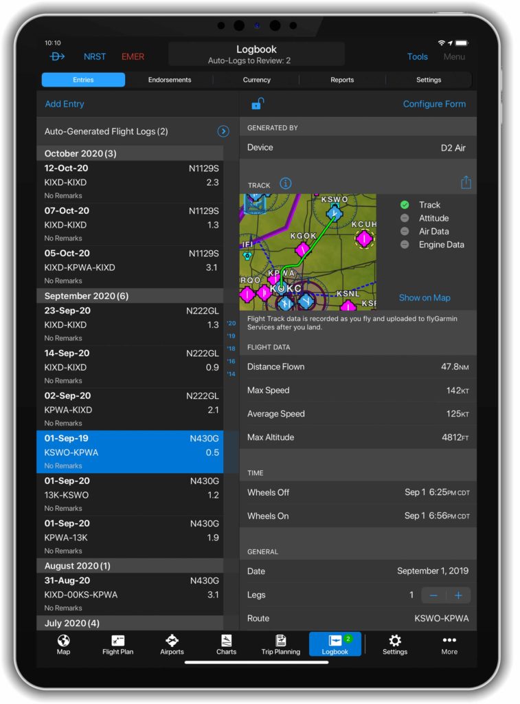
Our latest D2 series aviation watches – the D2 Air and D2 Delta series – can automatically detect the change in altitude during takeoff, initiating a flight recording logbook function. Once activated, it records the date, duration, total flight time and route. Upon landing, the information is automatically synced to a digital logbook on Garmin Pilot and flyGarmin.com – our safe and secure web-based cloud service – via a compatible smartphone.
 Air featuring flight logging capabilities.
Log flights, endorsements, track currency and more with Garmin Pilot
Our Garmin Pilot app can take flight logging a step further. In addition to automatically logging flights from takeoff to landing like the D2 Air and D2 Delta series, Garmin Pilot can record remarks, endorsements and help keep track of currency based on the number of takeoffs and landings in either day or night conditions.
Additionally, when operating Garmin Pilot from a GPS-equipped mobile device, or when it’s connected to a compatible external GPS device, it can automatically record flight track data during flights. With this feature enabled, flight data is recorded in-flight, then attached to the logbook entry upon landing. Recorded flight tracks can then be reviewed on the Garmin Pilot map page or flyGarmin.com.
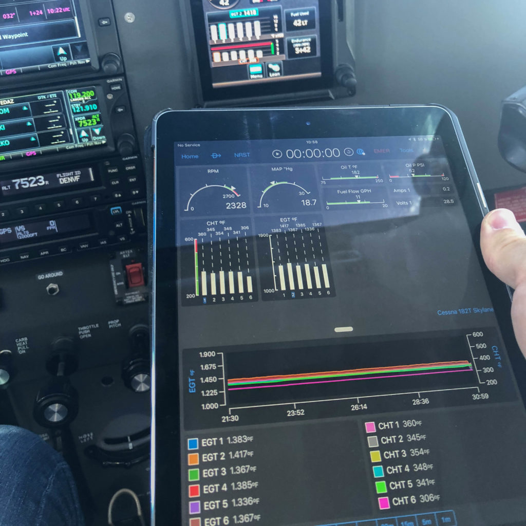
Wirelessly transfer engine performance data with Garmin avionics
Our flight logging feature set doesn’t just apply to the pilot’s flight time – we’ve created tools to help aircraft owners and operators gain valuable insights into their aircraft too. For aircraft equipped with a Garmin GI 275 EIS, an EIS-capable TXi flight display, G1000® NXi, G3000®1 or G5000®1 integrated flight deck, engine data can be wirelessly transmitted to Garmin Pilot on Apple® devices via our Flight Stream 510 wireless gateway2. For example, during a flight, crewmembers can transmit engine data to Garmin Pilot for real-time performance review. Upon landing, aircraft service technicians can review the flight data to help identify performance issues or maintenance needs. Saved performance data is automatically uploaded to flyGarmin.com and viewable on the logbook page.
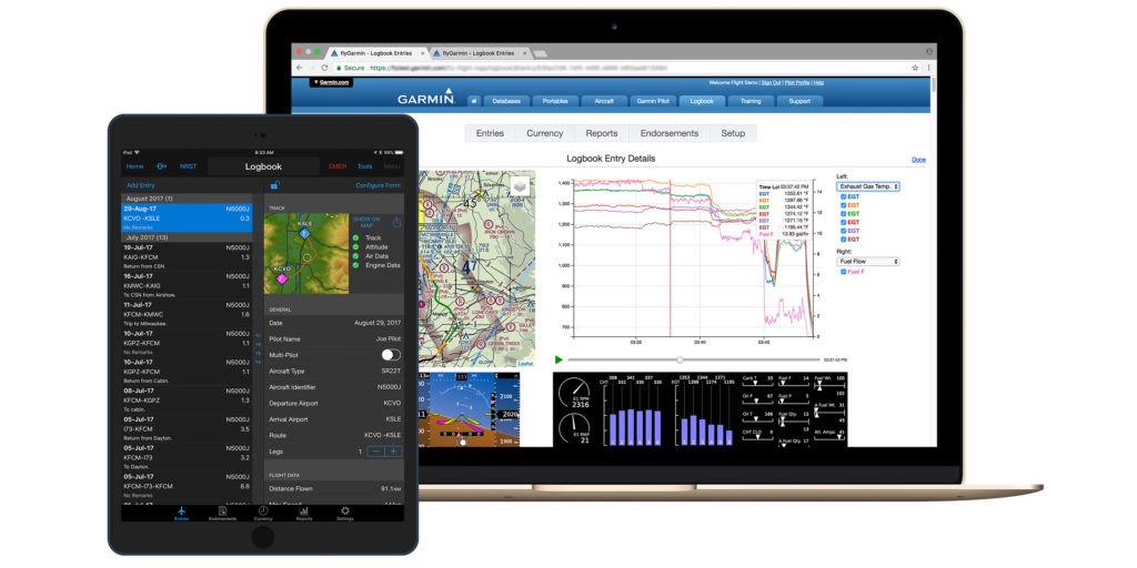
Review flight and engine data online at flyGarmin.com
Once flights are logged on select Garmin avionics3, D2 Air, D2 Delta series watches and Garmin Pilot, they are safely and securely stored on flyGarmin.com. From a desktop computer, tablet or mobile device, aircraft operators can review flight entries, flight tracks, engine performance data, currency reports and more. When it’s time to report hours and endorsements to employers or insurance, daily, monthly or yearly lookback reports can be generated on flyGarmin.com.
Exceedance alerts can be also be created on flyGarmin.com. This customizable tool can help operators monitor the health of their airframe and engine. A user-configured system limit is set at flyGarmin.com, then an email notification is sent to the operator upon landing if a limit was exceeded. Exceedance alerts can be generated for cylinder head temperature, oil temperature, aircraft pitch and more.
For more information about our flight logging solutions, engine information systems and avionics, visit Garmin.com/aviation.
1Compatibility varies by aircraft and system software level; see aircraft manufacturer for details
2Not required for GI 275 EIS
3Select Garmin avionics require a Flight Stream 510 (sold separately) and Garmin Pilot to do the automated transfer to flyGarmin.com — this transfer can also be done manually with SD card uploads
iPad, iPhone and Apple are trademarks of Apple Inc., registered in the U.S. and other countries.
The post Easy, Convenient Flight Logging with Garmin Products and flyGarmin.com appeared first on Garmin Blog.
https://www.garmin.com/en-US/blog/aviation/easy-convenient-flight-logging-with-garmin-products-and-flygarmin-com/
New G1000 NXi and G1000H NXi eLearning Courses Available
Pilots who fly behind our G1000® NXi and G1000H NXi for helicopters now have additional opportunities to refine their avionics skills. Our aviation training team introduced two new eLearning training courses for the G1000 NXi, as well as two separate eLearning courses for the G1000H NXi for helicopters. These courses are available in a virtual format allowing pilots to learn at their own pace. The G1000 NXi Fundamentals eLearning Course provides a foundational understanding of the system, while the G1000 NXi Essentials eLearning Course is focused on systems installed in high-performance piston and turbine engine aircraft. The two comprehensive eLearning courses for the G1000H NXi integrated flight deck titled G1000H NXi Fundamentals, and G1000H NXi Advanced-IFR, use scenario-based training to highlight helicopter-specific operations and are tailored for pilots new to the G1000H NXi system, in addition to those with experience wanting a deeper understanding of the system.
Core training topics
All four training courses build on a common core of training topics. These topics are common to all G1000 NXi and G1000H NXi systems but are tailored to the audience for each course. The topics include:
- Primary Flight Display (PFD) and Multifunction Display (MFD) function
- Audio Panel Features
- Automatic Flight Control System
- Hazard Avoidance Features
- Safety Features
- Abnormal Operations
- Managing Databases
- Operational Flight Scenario
Learn best-practices for G1000 NXi operational use
For those that are new to Garmin avionics, transitioning to advanced avionics, or perhaps want to refresh their understanding of the system, the G1000 NXi Fundamentals eLearning Course provides comprehensive training on the system designed for piston engine equipped aircraft. This course describes features of the system in detail and use a scenario to demonstrate how particular features function in different phases of flight in order to see this advanced system in action. In order to practice what you learned during this course, the Garmin G1000 NXi PC Trainer software is available for purchase online.

G1000 NXi for high-performance piston and turbine aircraft
For those operating high-performance piston or turbine-engine equipped aircraft, the G1000 NXi Essentials course presents best-practices for the G1000 NXi integrated flight deck by providing detailed training for pilots wanting to get the most out of the system. In addition to describing features in detail and showing how they can be used effectively in flight, scenario-based training demonstrates typical high-performance piston and turbine-engine aircraft operations, providing an opportunity to see the G1000 NXi system in full effect. For your specific or similar aircraft, the Garmin G1000 NXi PC Trainer software is available for purchase online, and provides the opportunity to take what you learned throughout the course and apply it. In addition to the core training topics, the G1000 NXi Essentials eLearning Course includes additional instruction on:
- Vertical Navigation
- Automatic Flight Control System
- Advanced Features
- User Waypoints
- Managing Databases
- Multiple Operational Flight Scenarios with different performance profiles
Build helicopter-specific system knowledge
The G1000H NXi Fundamentals course is designed for VFR helicopter pilots who are new to Garmin avionics, transitioning to advanced avionics, or perhaps want a refresher on the G1000H NXi. This allows the pilot to be comfortable with the avionics and maximize learning during valuable flight time. Learn how to take full advantage of the capabilities of the G1000H NXi system while gaining experience with operational use best practices. This virtual course allows pilots to learn at their own pace, details system features and provides a VFR flight scenario to show how these features are used in various phases of flight. Those that sign up for this course receive an additional scripted scenario for more practice through the Bell 407GXi G1000H NXi PC Trainer software, available for purchase online. The core training topics in the G1000H NXi Fundamentals eLearning Course have been tailored to helicopter-specific features and functionality, including differences for:
- PFD and MFD function
- Audio Panel Features
- Hazard Avoidance Features
- Operational Flight Scenario
- Scenario-Based Exercise
Enhance IFR helicopter skills with G1000H NXi
The G1000H Advanced-IFR course provides a detailed look at the G1000H NXi system and illustrates best practices for operational use of the flight deck, with a focus on Instrument Flight Rules (IFR). The course uses phase of flight scenarios to demonstrate typical IFR helicopter operation, and depicts common practices to maximize the benefits of system features and capabilities. For helicopter pilots who fly search-and-rescue missions, emphasis on user waypoints are included in the course scenarios. Pilots can further practice what they learned throughout the course with one of the additional scripted scenarios provided for use with the purchase of the Bell 407GXi G1000H NXi PC Trainer software. Some helicopter-tailored training topics covered in the Advanced IFR eLearning Course include:
- PFD and MFD function
- Automatic Flight Control System
- Hazard Avoidance Features
- Advanced Features
- User waypoints
- Operational Flight Scenarios

Proceed through the course at a pace that works best
Available immediately after purchase using a computer or tablet device with internet access, pilots can navigate through the virtual course at their own pace. Assessments throughout the course validate knowledge obtained of critical items while documenting the learning process. With the ability to pause lessons as needed to return to the lesson later, this is a convenient option for any pilot. Also, pilots can retake specific lessons or even the entire course during the subscription period.
The G1000 NXi Fundamentals eLearning course is available now for $94.95 USD, and the G1000 NXi Essentials eLearning Course is now available for $145.95 USD. Also available is the G1000H NXi Fundamentals eLearning Course for $74.95 USD, as well as the G1000H NXi Advanced IFR eLearning Course is available for $94.95 USD. For aviation training needs, including purchasing one of these eLearning courses, please visit www.fly.garmin.com/training.
For additional information, please contact aviation.training@garmin.com.
The post New G1000 NXi and G1000H NXi eLearning Courses Available appeared first on Garmin Blog.
https://www.garmin.com/en-US/blog/aviation/new-g1000-nxi-and-g1000h-nxi-elearning-courses-available/
Garmin Autoland Receives Aviation Week Network Grand Laureate Award
Garmin Autoland has earned another prestigious honor — Aviation Week Network’s 2020 Grand Laureate Award in the Business Aviation category. For 63 years, the Aviation Week Network has awarded the Grand Laureate for extraordinary aviation and aerospace achievements that embody the spirit of exploration, innovation and vision that inspire others to strive for progress, change and leadership.
“We are humbled and honored to be recognized by Aviation Week Network with this prestigious award in the Business Aviation category for the innovation of Autoland,” said Phil Straub, Garmin executive vice president and managing director, aviation. “The passion and commitment to safety through revolutionary developments like Autoland is shared by the entire Garmin team, who continuously drive our pioneering vision to develop advanced technologies that enhance aviation safety and potentially save lives.”
The Grand Laureate Award adds to a growing list of accolades Garmin Autoland has earned to date. Earlier this year, Fast Company recognized Autoland as a finalist in its 2020 World Changing Ideas Awards category, ultimately taking home honorable mention in the all-encompassing Best World Changing Idea Award in North America. The Kansas City Tech Council awarded Garmin with its 2020 Outstanding Contribution to Tech Award for Autoland — an honor presented to organizations that developed, or partnered in developing, a product or service that significantly advances the tech industry in their respective field. Autoland also reached the finals in the Kansas Manufacturing Council’s Coolest Thing Made in Kansas competition.
Garmin Autoland is certified in three 2020 model year aircraft — Piper M600 SLS, Cirrus Vision Jet and Daher TBM 940. In an emergency where the pilot is unable to fly, Autoland can take complete control of the aircraft, autonomously navigate around hazardous terrain, obstacles and weather while communicating with air traffic control and passengers. The system automatically selects the best airport for landing, considering runway length, distance, fuel range and other factors, and autonomously flies the approach and landing to a full stop on the runway¹. For more information about Autoland or our suite of Autonomi autonomous safety-enhancing technologies, visit Garmin.com/autonomi.
¹See Garmin.com/ALuse for Autoland system requirements and limitations
The post Garmin Autoland Receives Aviation Week Network Grand Laureate Award appeared first on Garmin Blog.
https://www.garmin.com/en-US/blog/aviation/garmin-autoland-receives-aviation-week-network-grand-laureate-award/
Garmin Aviation Training Team Adds Educational Webinars
The Garmin aviation pilot training team has announced additional instructor-led, scenario-based webinars. These free, one-hour courses provide online attendees with valuable product knowledge, operational techniques, and useful tips and tricks — without the concerns about travel and social distancing. They explore various Garmin avionics and provide foundational knowledge, flight planning and navigation techniques and much more.
Webinar Schedule
Garmin G3X Scenario-based Pilot Training Webinar
Nov. 23, 2020, at 7 a.m. CST: Sign Up
Nov. 23, 2020, at 10 a.m. CST: Sign Up
Nov. 24, 2020, at 7 p.m. CST: Sign Up
Garmin GPS Navigator Scenario-based Pilot Training Webinar (GPS 175, GNC® 355, GNX 375)
375)
Dec. 15, 2020, at 7 a.m. CST: Sign Up
Dec. 15, 2020, at 10 a.m. CST: Sign Up
Dec. 16, 2020, at 7 p.m. CST: Sign Up
Garmin GTN and TXi Scenario-based Pilot Training Webinar
Jan. 20, 2021, at 7 a.m. CST: Sign Up
Jan. 20, 2021, at 7 a.m. CST: Sign Up
Jan. 21, 2021, at 7 a.m. CST: Sign Up
Garmin GNS Scenario-based Pilot Training Webinar – Part I
Feb. 15, 2021, at 7 a.m. CST: Sign Up
Feb. 15, 2021, at 10 a.m. CST: Sign Up
Feb. 16, 2021, at 7 p.m. CST: Sign Up
Garmin GNS Scenario-based Pilot Training Webinar – Part II
March 16, 2021, at 7 a.m. CDT: Sign Up
March 16, 2021, at 10 a.m. CDT: Sign Up
March 17, 2021, at 7 p.m. CDT: Sign Up
Garmin Accident Mitigation Pilot Training Webinar
Join us as we explore and discuss accidents in aviation history and how we can use Garmin avionics — including GTN series navigators — to help mitigate and alleviate those safety concerns in our everyday flying.
April 21, 2021, at 7 a.m. CDT: Sign Up
April 22, 2021, at 10 a.m. CDT: Sign Up
April 22, 2021, at 7 p.m. CDT: Sign Up
Garmin Presents: Cirrus Perspective+ Scenario-based Pilot Training Webinar
May 12, 2021, at 7 a.m. CDT: Sign Up
May 13, 2021, at 7 a.m. CDT: Sign Up
May 13, 2021, at 10 a.m. CDT: Sign Up
Garmin GTN Mini-scenarios – Pilot Training Webinar
Have a specific scenario you would like the training team to talk about? These webinars are your chance! Our team will be taking select scenarios, as requested by you, and have in-depth discussions on how best to accomplish the scenarios with Garmin avionics.
June 16, 2021, at 7 a.m. CDT: Sign Up
June 16, 2021, at 10 a.m. CDT: Sign Up
June 17, 2021, at 7 p.m. CDT: Sign Up
We also offer a limited number of computer (PC) and iPad trainers as a convenient way to learn the basic operation of select Garmin avionics. These trainers simulate the behavior of an avionics system interface — such as GTN, GTN Xi and TXi series products — and can be downloaded at www.Garmin.com or the Apple App Store. For all of your aviation training needs, please visit fly.garmin.com/fly-garmin/training/.
The post Garmin Aviation Training Team Adds Educational Webinars appeared first on Garmin Blog.
https://www.garmin.com/en-US/blog/aviation/garmin-aviation-training-team-adds-educational-webinars/
D2 Air: Aviator Smartwatch with Powerful Flight Functionality, Vibrant AMOLED Display
Introducing D2 Air, our latest GPS smartwatch for the modern pilot with powerful aviation capabilities and a sleek, new touchscreen design that can be worn 24/7. The newest addition in the D2 aviator watch series, the D2 Air offers tools for all phases of flight, including weather, direct-to navigation, airport information, flight logging, Pulse Ox1, and much more. To keep up with life on the go, the D2 Air incorporates connected features like smart notifications2, Garmin Pay contactless payment solution3 and phone-free music, along with enhanced health monitoring, and animated workouts.
“The D2 Air is an exciting option for current and aspiring pilots, as well as the aviation enthusiast,” said Carl Wolf, vice president of aviation sales and marketing. “The D2 Air offers a bright and striking display with valuable capabilities that benefit pilots in the air while offering advanced smartwatch features on the ground, placing the D2 Air aviator smartwatch in a category of its own.”
A Dedicated In-Flight Navigator on Your Wrist
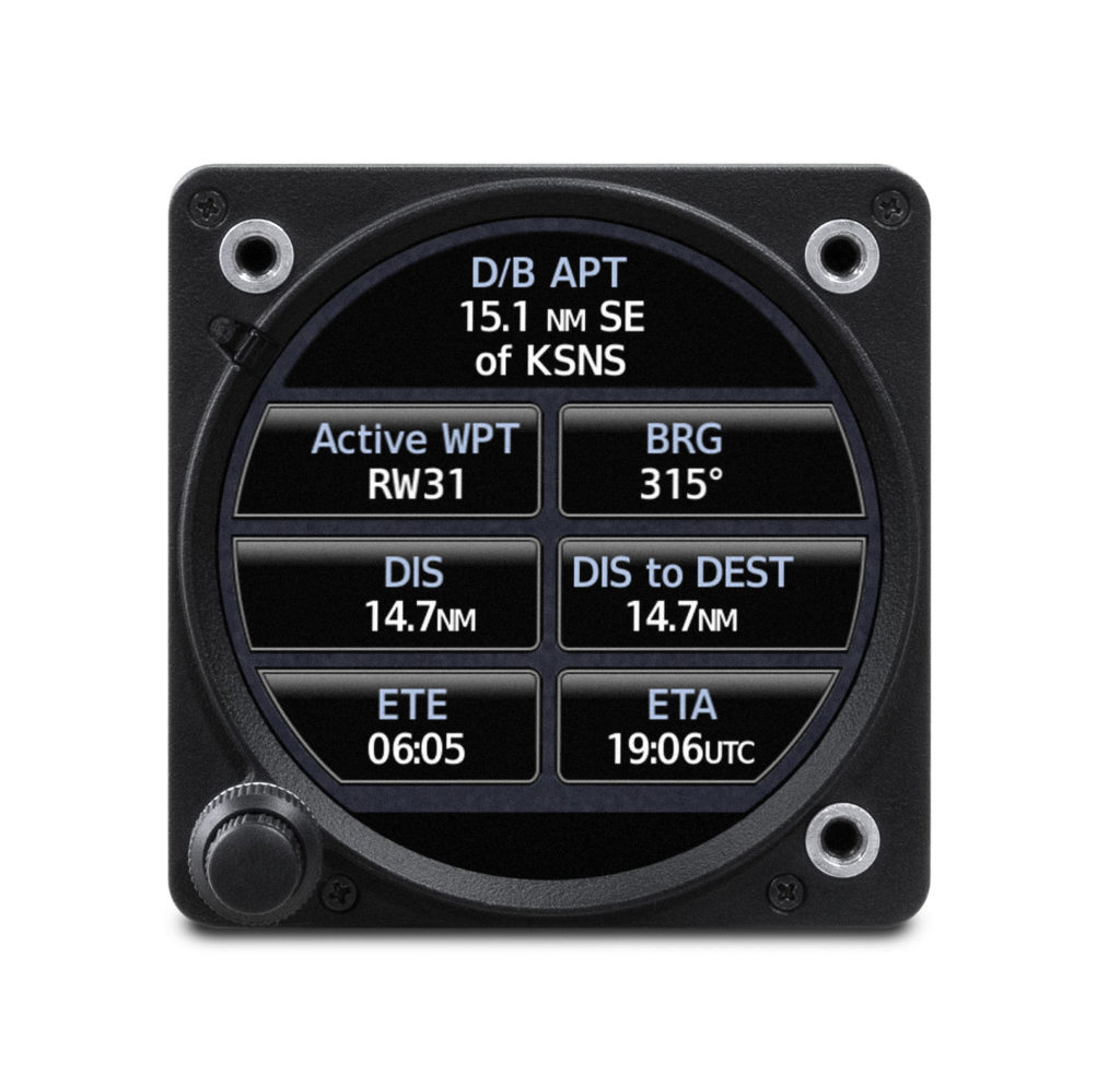
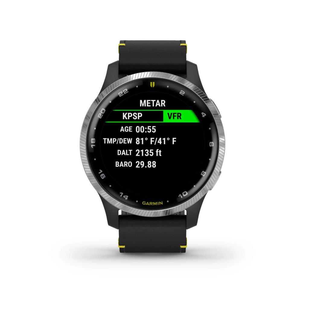
The D2 Air includes several pre-flight features and tools, with the ability to display multiple time zones including Zulu time, and METAR and TAF aviation weather reports and forecasts, to name a few. Additionally, airport information such as runway orientation with wind components, runway lengths, airport frequencies and traffic pattern altitudes are easily accessible for each airport.
Preloaded with a worldwide navigation database containing NAVAIDs and Intersections, a waypoint info page, direct-to navigation, a three-axis compass with a horizontal situation indicator (HSI), and an altimeter with adjustable barometric setting, the D2 Air is packed with features to assist aviators in navigation and enhance situational awareness.
The D2 Air utilizes Garmin Pilot flight plan transfer4, allowing for an easy way to access to flight plan information by seamlessly transferring flight plans into the watch. Aviation alerts such as speed, time, distance, elevation, and a fuel timer are available on the D2 Air watch during flight. For post-flight ease, the D2 Air integrates with flyGarmin.com logbook5 to sync post-flight data such as date, duration, and route of flight.
Smart Features for Life on the Go
The D2 Air provides all-day connection and convenience for life on the go. When paired with a compatible device, users can receive smart notifications for incoming calls, text messages, calendar reminders and more on the vivid 1.2” AMOLED touchscreen display. Users can also download songs or playlists6, including those from third-party music services like Spotify, Amazon Music and Deezer6. And with Garmin Pay, pilots can make contactless payments right from their wrist3.
Health, Wellness and Sports
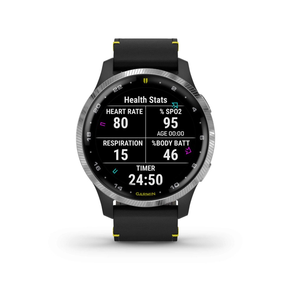
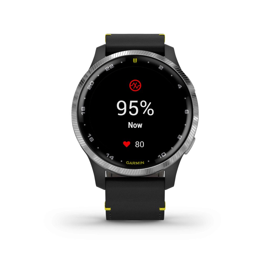
As a multifunctional smartwatch, the D2 Air offers a broad range of health and wellness features, including advanced sleep monitoring, respiration tracking, stress tracking, hydration tracking, the Body Battery energy monitor enabling pilots to track energy levels all-day, Pulse Ox that gauges blood oxygen saturation levels for reference when flying at altitude, and more1. With GPS, Elevate wrist-based heart rate7, and over 20 built-in indoor and outdoor sports apps including walking, running, cycling, pool swimming, golf and more, the D2 Air is packed with features to keep up with an active lifestyle.
The D2 Air’s AMOLED screen brings workouts to life with an additional 40+ on-device animated workouts for strength training, cardio, yoga and Pilates. Easy-to-follow workouts demonstrate proper form and technique right on the user’s wrist and can be downloaded at no charge from the Garmin Connect app5.
Designed for Flying in Style
The design of the D2 Air features an aviation-themed watch face, stylish stainless-steel finish on a 43.2mm bezel and an elegant premium black leather strap with yellow accents. The D2 Air boasts a rugged scratch- and damage-resistant lens with Corning® Gorilla® Glass 3 for durability, allowing pilots the freedom to use the watch as it was designed in a demanding flight environment. Also included with the D2 Air is a sporty silicone quick-release watch band, allowing for a seamless transition between exercise or a round of golf, to a more formal leather strap better suited for business environments or a night out, with additional band options available and sold separately.
The D2 Air boasts a battery life of up to 5 days while using smart notifications and pre-flight planning tools, and up to 10 hours of battery life when continuously using GPS and Pulse Ox while flying. Pilots can utilize the D2 Air’s always-on mode to ensure all their information is right at hand when they need it. The D2 Air is available now for a suggested retail price of $499.
1 This is not a medical device and is not intended for use in the diagnosis or monitoring of any medical condition; see Garmin.com/ataccuracy. Pulse Ox not available in all countries.
2 When paired with a compatible smartphone; see Garmin.com/ble
3 View current supported country, payment network and issuing bank information at Garmin.com/GarminPay/banks
4 When paired with a compatible smart device downloaded with the Garmin Pilot app
5 When paired with a compatible smart device downloaded with the Garmin Connect app
6 May require premium subscription by a third-party music provider
7 See Garmin.com/ataccuracy
The post D2 Air: Aviator Smartwatch with Powerful Flight Functionality, Vibrant AMOLED Display appeared first on Garmin Blog.
https://www.garmin.com/en-US/blog/aviation/d2-air-aviator-smartwatch-with-powerful-flight-functionality-vibrant-amoled-display/