Category Archives for Aviation
Retrofit G1000 NXi Availability Expanded
We are excited to announce the addition of five aircraft eligible for G1000 NXi integrated flight deck upgrade. These aircraft currently equipped with a WAAS G1000 integrated flight deck include the Cessna 172/182/206 and Beechcraft Bonanza and Baron. The G1000 NXi includes a wealth of features and capabilities such as wireless connectivity, SurfaceWatch, map overlay within the HSI and more. Aircraft owners and operators can easily upgrade from the G1000 to the modern, state-of-the-art G1000 NXi with minimal aircraft downtime and installation.
“Based on the success of the G1000 NXi upgrade programs that are
available today, we’re excited to deliver this upgrade to thousands of additional
aircraft owners and operators,” said Carl Wolf, vice president of aviation
sales and marketing. “With the G1000 NXi, customers experience faster
performance and find tremendous value in new features like wireless cockpit connectivity,
visual approach guidance, SurfaceWatch, map HSI and more, all of which make
this upgrade an absolute must-have in every aircraft.”
Aircraft that currently have a WAAS G1000 integrated flight deck that
are now eligible for the G1000 NXi upgrade are as follows:
- Cessna 172 R/S
- Cessna 182T
- Cessna 206H
- Beechcraft Bonanza
G36 - Beechcraft Baron G58
As part of the G1000 NXi upgrade for these aircraft, Flight Stream 510 and Connext technology enables Database Concierge, the wireless transfer of aviation databases from the Garmin Pilot app on a mobile device to the G1000 NXi integrated flight deck. Additional features enabled by the Flight Stream 510 include two-way flight plan transfer, the sharing of traffic, weather1, GPS information, back-up attitude information and more, among the G1000 NXi and the Garmin Pilot, FltPlan Go and ForeFlight Mobile applications. The G1000 NXi also includes geographical map overlay within the horizontal situation indicator (HSI), visual approach guidance and more.
The G1000 NXi supports the display of various Automatic
Dependent Surveillance-Broadcast (ADS-B) In benefits, including traffic and
subscription-free Flight Information Service-Broadcast (FIS-B) weather1. Other standard features include SurfaceWatch
runway monitoring technology, which provides visual and aural cues to help
prevent pilots from taking off or landing on a taxiway, on a runway that is too
short, or on the wrong runway based on performance data entered during
preflight. Visual and audible runway distance remaining annunciations are also
available via SurfaceWatch. Additional features that are available as standard
include animated NEXRAD weather radar imagery1, Vertical Situation
Display (VSD), IFR enroute charts, VFR sectionals and Visual Reporting Points
(VRPs).
Modernized displays offer improved
readability, while state-of-the-art dual-core processors provide smoother
panning throughout the displays and faster map rendering. Because the flight
displays initialize in seconds, pilots have immediate access to frequencies, flight
plan data and more, saving valuable time in the cockpit. The G1000 NXi
integrated flight deck also incorporates contemporary animations and new LED
back-lighting, offering increased display brightness and clarity, reduced power
consumption and improved dimming performance.
Aircraft owners and operators can easily upgrade to the G1000 NXi with little aircraft down time and disruption of the panel because the displays preserve the same footprint and connectors, so panel and wiring modifications are minimized. Garmin is currently taking orders for the G1000 NXi upgrade in the Cessna 172/182/206, Beechcraft Bonanza and Baron and expects deliveries to begin in July. The G1000 NXi upgrade for these aircraft is available for a list price of $28,995 from Garmin Authorized Dealers (installation and hardware charges may apply), which includes the avionics system software and STC Letter of Authorization (LOA) from Textron Aviation for list price of $4,000. The upgraded components of the G1000 NXi also come with a two-year warranty, which is supported by our award-winning aviation support team. For additional information regarding the G1000 NXi upgrade, visit: www.garmin.com/aviation or contact a Garmin Authorized Dealer.
1.Compatible
datalink required.
The post Retrofit G1000 NXi Availability Expanded appeared first on Garmin Blog.
https://www.garmin.com/en-US/blog/aviation/retrofit-g1000-nxi-availability-expanded/
EAA AirVenture Oshkosh 2019: New Avionics and Showcase Aircraft
The 50th edition of EAA AirVenture at Oshkosh — one of the world’s greatest aviation celebrations — opens its gates to aircraft owners, pilots and fans July 22-July 28, 2019. During that week, airplanes and enthusiasts will converge to create the busiest airspace in the world. This year we’ll be highlighting many of our popular general aviation avionics — tailor-made products for every experimental homebuilder to business traveler.
Display Aircraft — “Draco,” Cessnas, Beechcraft and more!

We’ll be hosting a mix of certificated and experimental aircraft at our display just west of Boeing Plaza. Mike Patey and his experimental Wilga, known as “Draco,” will be at our exhibit—this STOL record-breaking, highly modified aircraft features TeamX’s G3X Touch avionics for experimentals. We’ll also be showcasing a Cessna 182 and Beechcraft A36 Bonanza equipped with G500 TXi and GTN 650/750 series avionics. Additionally, another Cessna 182 will be on hand equipped with our new G3X Touch for certificated aircraft. See these aircraft and instrument panels up close, and even talk with a few of their owners and builders at our booth.
Advanced Avionics
The ADS-B deadline is less than six months away. The closer we get to Dec. 31, 2019, the busier avionics installers will inevitably become. Our low-cost, easy-to-install GDL 82 ADS-B datalink allows you to keep your existing Mode A/C transponder. Wanting to upgrade your transponder altogether? Our GTX 335 provides simple ADS-B “Out” compliance in a transponder upgrade. The next step in our ADS-B line is the GTX 345 — an all-in-one ADS-B transponder featuring ADS-B “In” and “Out” for enhanced weather and traffic information in the cockpit. And our new GNX 375 combines an ADS-B “In” and “Out” transponder with LPV approach capability in a GPS navigator, providing more awareness and capability for an aircraft. It’s a great direct replacement for GPS 150/155, GX 50/55, as well as the KLN 89/90/94 series.
Earlier this year, our TeamX experimental avionics group
introduced its G3X Touch flight display to the certificated market. What had
been a mainstay within the experimental community is now available for more
than 500 certificated aircraft models.
Our new cost-effective solutions for both experimental and
certificated aircraft, including our two new cost-effective GPS navigators: GPS
175 and GNX 375 (with ADS-B “In” and “Out” transponder), give owners an
affordable route to LPV approach capability for their aircraft.
Also be sure to check out our G500/G600 TXi series touchscreen flight displays. See how these advanced avionics offer powerful PFD, MFD and EIS solutions for a number of aircraft platforms.

On-site Seminars and Pilot Training
Visitors can attend daily seminars at the exhibit that highlight our range of avionics, from how-to product demonstrations to determining which of our solutions are the best fit for your aircraft. Plus, our award-winning pilot training team will be on site at the Hilton Garden Inn on the Oshkosh airfield, providing real world, hands-on, scenario-based training for the Garmin GTN 750/650 series navigators. These one-day courses (Monday, July 22 through Friday, July 26) are designed to explain the ins and outs of flight planning and instrument procedures. Each participant will be provided with their own kiosk housing real Garmin avionics, a training syllabus for in-class and at-home use, as well as a lunch overlooking the airfield from the hotel patio. Cost for this training is $99 and seats are limited, so register today to reserve your spot! Click here to sign up.
Full seminar schedule:
| Tent 1 | Time |
| G3X Touch TeamX Academy: How to Install G3X Touch Monday and Thursday: System Introduction Tuesday and Friday: CAN Bus Design Wednesday and Saturday: Autopilot Config & Checkout |
8 a.m. |
| G3X Touch TeamX Academy: How to Install G3X Touch Monday and Thursday: Wiring Tips & Tricks Tuesday and Friday: Databases, Software & Configuration Wednesday and Saturday: GPS Navigation Interfaces |
9 a.m. |
| G3X Touch TeamX Academy: How to Fly G3X Touch Monday and Thursday: Intro to G3X Touch Tuesday and Friday: G3X Touch Autopilot Wednesday and Saturday: IFR with G3X Touch & Touchscreen Navigators |
10 a.m. |
| Low-cost Upgrades for Certificated Aircraft: G3X Touch, GPS 175/GNX 375, G5, GFC 500, GTX 335, GMA 345 and more | 11 a.m. |
| Cost-effective ADS-B Solutions: GNX 375, GTX 345/GTX, 335 series, GDL 82 and more | 12:30 p.m. |
| Low-cost Upgrades for Certificated Aircraft: G3X Touch, GPS 175/GNX 375, G5, GFC 500, GTX 335, GMA 345 and more | 1:30 p.m. |
| Tent 2 | Time |
| Real-world Flying with Garmin Avionics: GTN 750/650 series and GPS 175/GNX 375 as well as GFC 500/600 Monday, Wednesday and Friday: Approaches with Touch Screen Navigators & Autopilots Tuesday, Thursday and Saturday: GTN Series VNAV & Autopilot |
8 a.m. |
| Cost-effective ADS-B Solutions: GNX 375, GTX 345/GTX 335 series, GDL 82 and more | 9:30 a.m. |
| Flying with iPad Tablets: Getting Started with Garmin Pilot | 10:30 a.m. |
| Flying with iPad Tablets: Pro Garmin Pilot Tips & Tricks | 11:30 a.m. |
| Upgrading Avionics: GTN 750/650 series, G600 TXi/G500 TXi/EI TXi and GFC 600/GFC 500 | 12:30 p.m. |
| Avionics for Experimental Aircraft: G5 to G3X Touch | 2 p.m. |
The Garmin exhibit will be located just west of the Boeing Plaza. Be sure to follow us on social media throughout the show and tag your photos at our handle—@GarminAviation and #flyGarmin!
The post EAA AirVenture Oshkosh 2019: New Avionics and Showcase Aircraft appeared first on Garmin Blog.
https://www.garmin.com/en-US/blog/aviation/eaa-airventure-oshkosh-2019-new-avionics-and-showcase-aircraft/
G5000 Integrated Flight Deck for Citation Excel/XLS Now Certified
The G5000 integrated flight deck for Textron Aviation’s Citation Excel and Citation XLS has achieved is now certified. The G5000 integrated avionics suite modernizes the cockpit, significantly reduces operational costs, addresses airspace modernization requirements, and solves long-term concerns related to parts obsolescence.
“With close to 50 customer commitments, the market has proven that the ever-popular Citation Excel/XLS
is a perfect platform for the G5000,” said Carl Wolf, Garmin vice president of aviation sales and
marketing. “Based on the tremendous success of our integrated flight deck retrofits, as well as the
reception of our early adopter programs, Citation Excel/XLS owners and operators are excited to start
flying behind the G5000 as it offers an unprecedented level of situational awareness, yields a significantly
lower cost of operation and delivers an exceptional in-flight experience.”

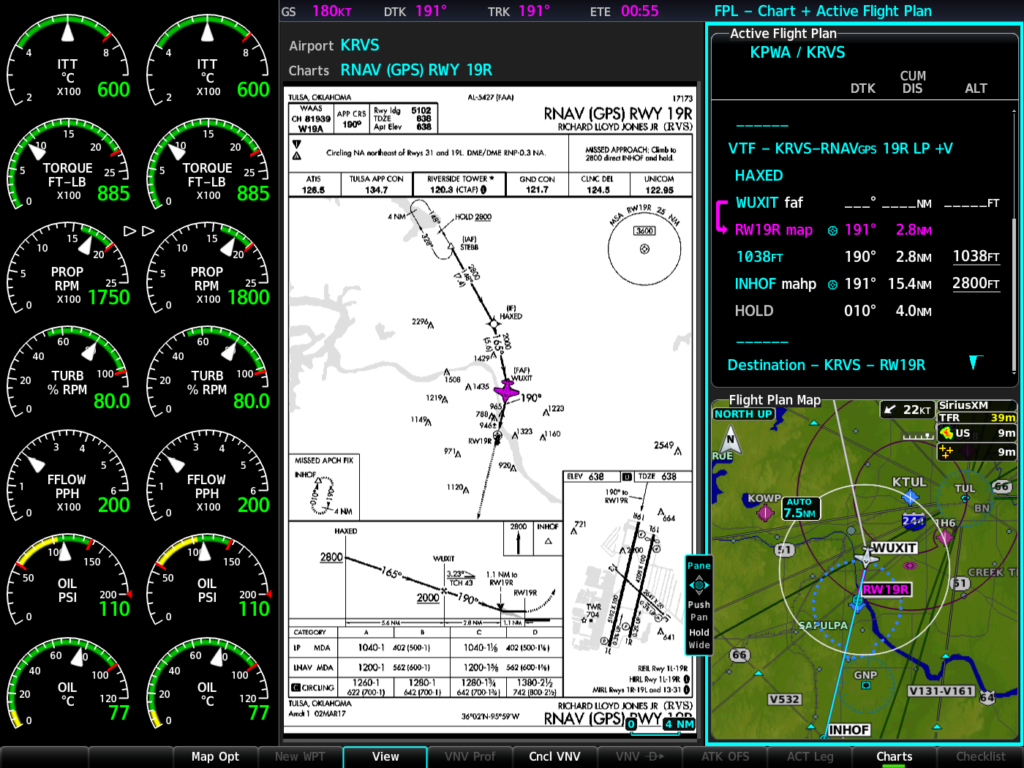
The G5000 integrated flight deck for the Citation Excel and Citation XLS features three landscape- oriented flight displays with split-screen capability, allowing pilots to simultaneously view maps, charts, checklists, TAWS, TCAS, flight plan information, weather and more. Electronic charts and Garmin SafeTaxi airport diagrams are geo-referenced and can be viewed across all three displays. Intuitive touchscreen controllers serve as the pilot interface to the flight deck and contribute to the ease of operation and seamless transition between various pages.
It also includes a fully digital Automatic Flight Control System (AFCS), offering precise performance throughout the aircraft’s flight envelope. New to the Citation Excel, Emergency Descent Mode (EDM) is available as a standard feature with the G5000 and is enabled by the autopilot in the event of a loss in aircraft pressurization. Safety enhancing underspeed protection (USP) is an optional feature that allows the autopilot to assist with airspeed management, while also enabling fully coupled go-arounds, greatly reducing pilot workload.
Additionally, with this upgrade comes a fully integrated, Federal Aviation Administration (FAA) and European Aviation Safety Agency (EASA) rule-compliant Automatic Dependent Surveillance- Broadcast (ADS-B) Out solution. Additionally, operators gain access to more airports and lower approach minimums throughout the world as the G5000 has PBN/RNP 0.3 with LPV/APV approach capability.
With the G5000, pilots can receive departure clearances faster using FAA Data Comm. Controller Pilot
Data Link Communication-Departure Clearance (CPDLC-DCL) automates Clearance Delivery operations at
over 60 of the busiest airports in the U.S. and enables wireless receipt and automatic loading of the
departure clearance into the G5000. Additionally, the G5000 supports En Route CPDLC capability, which
allows the exchange of data link messages with Air Route Traffic Control Centers (ARTCCs) in the U.S.
This capability is expected to be available at all ARTCCs by the end of the year. European operators can
also meet Link 2000+ requirements using this same technology. FAA Data Comm and Link 2000+ require
optional equipment and services.
The G5000 for the Citation Excel/XLS also supports additional options, such as:
- SVT synthetic vision technology, which presents a 3D virtual depiction of terrain, obstacles, traffic and the runway environment.
- SurfaceWatch, which supports visual and aural cues to help prevent pilots from taking off and landing on a taxiway, on a runway that is too short or on the wrong runway based on performance data entered during preflight.
- Datalink weather, including access to global weather products and text/voice communication through the Iridium satellite network.
- Advanced Doppler weather radar features including ground clutter suppression and turbulence detection.
As an additional option for this upgrade, Connext wireless cockpit connectivity via the Flight Stream 510, enables wireless flight plan transfer and more between compatible mobile devices, including
Garmin Pilot, FltPlan Go and ForeFlight Mobile.Owners and operators can more easily manage flight plans with the Flight Stream 510, while also receiving additional benefits such as the sharing of traffic, weather, GPS and more across multiple mobile devices in the cockpit. Flight Stream 510 also enables Database Concierge, the wireless transfer of aviation databases from the Garmin Pilot app on a mobile device to the G5000.
G5000 eLearning training courses
In conjunction with this certification, Garmin has launched two new eLearning courses that are tailored to the G5000 in the Citation Excel/XLS. These courses review a variety of features, operational considerations and scenarios so pilots can familiarize themselves with the capabilities of the G5000. For additional information, visit www.flyGarmin.com/training.
For more information on G5000 and Garmin Services
The G5000 integrated flight deck upgrade for the Citation Excel and Citation XLS is available immediately from Textron Aviation Service Centers and select Garmin Authorized Dealers. For additional information regarding the G5000 upgrade program for the Citation Excel/XLS, contact Dave Brown at (913) 440-1714 or dave.brown@garmin.com or visit www.garmin.com/businessaviation. For additional information on Garmin Services and how to subscribe, visit: www.fltplan.com/aboutus.
The post G5000 Integrated Flight Deck for Citation Excel/XLS Now Certified appeared first on Garmin Blog.
https://www.garmin.com/en-US/blog/aviation/g5000-integrated-flight-deck-for-citation-excel-xls-now-certified/
Turbine Engine Monitoring and Analysis Announced for G600 TXi and G500 TXi
Our aviation team has expanded the engine monitoring capability on the G600 TXi/G500 TXi and Engine Indication System (EIS) TXi flight displays to now include single-engine turboprop aircraft. Pratt & Whitney PT6A turboprop engine display compatibility is certified for several popular aircraft models, including the Cessna 208/208B, Daher TBM 700/TBM 850 and the Piper PA46-310P/350P JetPROP. Engine information can be viewed on a single 10.6-inch TXi display, which can accommodate primary flight display (PFD) information, a multifunction display (MFD) and a vertical EIS strip, and on the 7-inch portrait display, which serves as a dedicated EIS display. Features of the EIS system for turbine aircraft include engine timers, exceedance recordings, dynamic engine indications, as well as wireless data logging that combine to reduce pilot workload, improve engine efficiency and reduce maintenance costs. Additionally, existing engine sensors can be paired with the TXi displays, saving installation time and cost.
“With EIS TXi, owners and operators have a path to replace maintenance-prone engine instrumentation
by upgrading to a modern, more capable system that gives them additional insight into their aircraft’s
operational performance in real-time,” said Carl Wolf, vice president of aviation sales and marketing.
“Because the engine is a significant investment on every aircraft, we’re excited to provide this powerful
tool that allows pilots to easily identify and review aircraft engine performance data so they can more
efficiently manage the aircraft.”
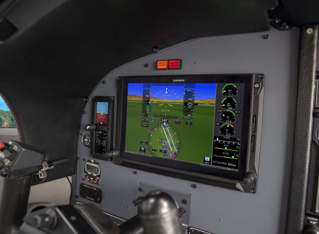
Dynamic gauge limits and indications
All EIS TXi gauge indications display real-time turbine engine information using distinct colors, bands and
radials to clearly label specific limitations so pilots can more easily interpret engine data at-a-glance.
Select turboprop gauges such as engine torque, prop RPM (NP), gas generator RPM (NG), and engine
temperature (ITT) can be configured to change their markings based on pressure altitude, outside air
temperature and more. Dynamic indications are configured during installation so pilots can more easily
operate the engine within its limitations during changing flight conditions. Additional standard gauges
include oil pressure and temperature, as well as fuel flow and electrical system status.
Limit timers and exceedance recordings
Utilizing gauge limit timers, EIS TXi helps pilots maintain the engine within its allowed limits to avoid
engine exceedances and as a result, costly maintenance procedures. For example, once a limit is
reached, a countdown timer is displayed alongside the engine gauge. This timer is an indication to the
pilot that he/she needs to mitigate the exceedance. If the time-based limit is exceeded, the timer and
gauge begin to flash and the pilot receives a notification that an exceedance has been recorded.
Simultaneously, the EIS TXi system automatically logs a variety of information, including the parameter
that was exceeded, duration, highest value that was recorded, time, date and more. The pilot can then
review the exceedance and share it with maintenance professionals for post-flight analysis.
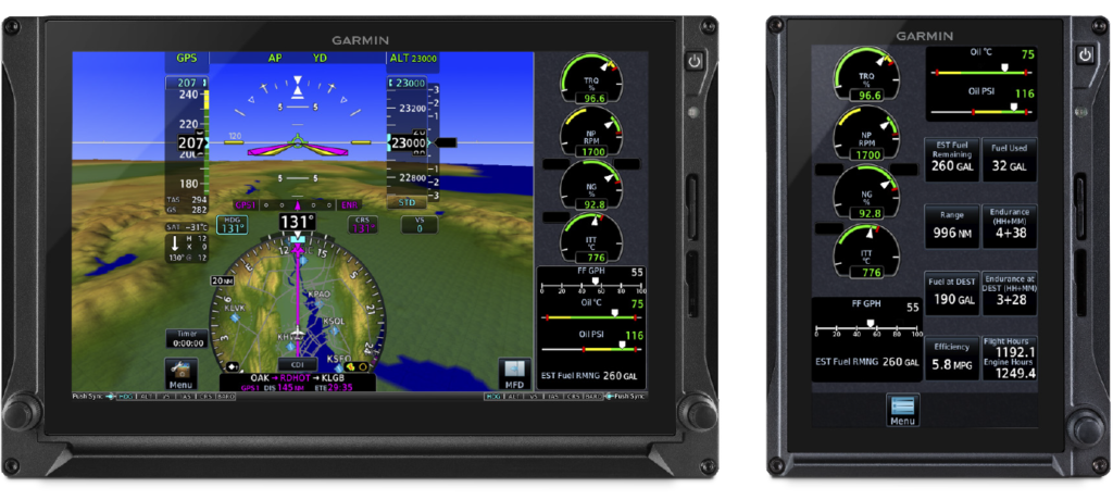
Wireless flight data logging
To assist with tracking maintenance activities, controlling operating costs and analyzing overall engine health, built-in engine data logging is included with EIS TXi. Aircraft performance, engine data and any exceedances that are recorded during a flight are automatically stored on an SD card in the display. When the EIS TXi display or the GTNTM 650/750 navigators are paired with the Flight Stream 510 wireless gateway, information is wirelessly transferred and stored within the Garmin Pilot app and automatically uploaded to the flyGarmin website. Engine and flight cycles are also recorded to help identify aircraft systems that depend on those limits, such as pressurization systems and other life-limited parts.
Add precision to fuel planning
Pilots can more precisely monitor fuel calculations with EIS TXi, which includes an integrated fuel
computer. After making a fuel stop, pilots can enter the fuel data within EIS TXi by selecting “full fuel” or
by adding a specified amount in pounds, gallons, liters or kilograms. When airborne, the system monitors
fuel flow and GPS information to estimate fuel range, endurance and how much fuel is expected to be
available at the destination airport.
The G600 TXi/G500 TXi and standalone EIS TXi are certified for select turbine aircraft, including the Cessna 208/208B, Daher TBM 700/TBM 850 and the Piper PA46-310P/350P JetPROP. Pricing for a standalone EIS TXi flight display starts at a list price of $14,800. The TXi series also comes with a two-year warranty, which is supported by our award-winning aviation support team. For additional information, visit www.garmin.com/TXi or contact a local Garmin authorized dealer.
The post Turbine Engine Monitoring and Analysis Announced for G600 TXi and G500 TXi appeared first on Garmin Blog.
https://www.garmin.com/en-US/blog/aviation/turbine-engine-monitoring-and-analysis-announced-for-g600-txi-and-g500-txi/
COPA Adventure: Navigating Mexico, Central America with Expert Guidance
Within the United States, aircraft owners and pilots benefit from what many consider the best, and easiest, general aviation system in the world. In order to get from point A to point B domestically, it’s relatively simple. Pilots need to submit flight plans and study up on airspace, approach procedures and airport layouts for a given destination. But when it comes to crossing international borders, especially Canada, Mexico, Central America or the Caribbean, there are additional levels of complexity compared to our day-to-day domestic flights in the U.S. Overflight fees, airspace procedures, customs and international handling requirements often vary from country to country, which can be complicated and increase workload and stress on an international flight. Fortunately, our FltPlan.com International Handling services can help make these trips more convenient. Regional aviation experts based in Mexico, Central America and the Caribbean — aircraft operators can utilize helpful guidance, planning and handling services from local professionals. Earlier this year, members of the Cirrus Owners and Pilots Association (COPA) embarked on a fly-out adventure to Mexico and Guatemala and took advantage of FltPlan.com integration with Garmin avionics and local expert guidance from Caribbean Sky Tours.
Destination: Central America
COPA is an organization of more than 5,700 members worldwide
that focuses on education, training and safety programs for the Cirrus aircraft
fleet. In addition to helping keep their aircraft properly maintained and
pilots proficiently trained, they also have regular social gatherings and
fly-outs to help bring their members together. For the third straight year,
members united in their Cirrus SR20s, SR22s and even an SF50 Vision Jet to
explore destinations south of the border. Their adventures range from Mexico
and Costa Rica to as far south as Panama, visiting tourist spots, cultural
landmarks and UNESCO World Heritage sites.
This year’s trip kicked off on March 9, when 11 aircraft
departed their home bases from all over the United States for two jumping-off
points: Brownsville, Texas, and Key West, Florida.
Comprehensive Trip Planning and Preparation
Planning for the trip began long before their departure, with
detailed briefings to prep the pilots on the different international
procedures, airspace requirements and fees, plus customs and handling
instructions for their upcoming destinations. The team also managed the flight
plans, overflight and airspace fees, coordinated all the ground handling in
advance and made hotel accommodations for the visiting crews.

Added Convenience for International Departures and
Arrivals
On March 10, their international flight plans were filed, and the 11 aircraft departed from south Texas and Florida for Veracruz, Mexico. Along the way, each aircraft’s progress was monitored by the Caribbean Sky Tours team by using Garmin inReach satellite communicators.* With the inReach devices, the team was able to not only track the progress of each aircraft, but also have two-way communication in-flight. With preparations already made in advance for each destination, ground handlers were standing by upon landing in Veracruz. From there, the aircraft completed the 850-mile journey to Mundo Maya, Guatemala, where crews spent several days enjoying local food, touring historic ruins and taking in the local culture.
At the end of their Guatemalan stay, pilots were briefed on
the procedures required for the next stage of their journey — Campeche, Mexico.
Upon arrival they were met with preplanned ground handlers, fuel and customs
services. After another extended stay enjoying local cuisine, tourist
destinations and culture, the group was ready to return to the states by way of
Key West and Brownsville.

Expert International Guidance from FltPlan.com
Through our FltPlan.com services, aircraft owners and
operators have access to International Handling and Airspace Overflight
expertise. Service begins by signing up for a free account, where web-based
flight planning, certified weather, airport information and more is available
at no cost. When flight plans are filed to international destinations through
FltPlan.com, additional handling services and guidance are available. The team
has specialists based in Mexico, Central America and the Caribbean, ready to
help pilots and crews with every aspect of an international trip — from flight
planning and flight tracking to electronic advanced passenger information
services (eAPIS), ground handling coordination and customs. Add convenience and
peace of mind to any international trip with local expert guidance along the
way, before, during and after.
For more information about our FltPlan.com tools, plus international handling services and expert guidance, visit our website and sign up for an account today.
*Jurisdiction
restrictions may apply.
The post COPA Adventure: Navigating Mexico, Central America with Expert Guidance appeared first on Garmin Blog.
https://www.garmin.com/en-US/blog/aviation/copa-adventure-navigating-mexico-central-america-with-expert-guidance/
Appareo Acquires Aerovie

Planned enhancements to Aerovie will result in the industry’s most advanced electronic flight bag
FARGO, North Dakota (June 18, 2019) — Appareo today announced the acquisition of Aerovie, LLC, developer of the Aerovie electronic flight bag (EFB) suite that includes AHRS and synthetic vision, VFR sectional, IFR low/high, and geo-referenced approach charts.
Since introducing the first Stratus portable ADS-B receiver in 2012, Appareo has become the industry leader in the design and production of ADS-B equipment for general aviation. While the company has continued expanding on the hardware features and capabilities of Stratus receivers and transponders, it has been reliant on third-party flight apps to interface with the information provided by Stratus receivers. The first three generations of Stratus receivers (Stratus 1, Stratus 2, and Stratus 1S/2S/2i) were integrated with ForeFlight Mobile. The latest model, Stratus 3, was designed with “Open ADS-B Mode,” which means it integrates with any EFB app using GDL 90 protocol.
With the introduction of Stratus 3 last year, the engineers at Appareo began working with many EFB developers to ensure close integration with the newest model. Aerovie was one of the first companies to support Stratus 3 in its app.
“We were very impressed with the Aerovie team as we worked on the integration, and pleased with how smoothly it went,” said Appareo Aviation President Kris Garberg. “I started flying with the Aerovie app and Stratus 3 last year, and I was so impressed with the features and user experience that it became my ‘go to’ EFB.”
Garberg’s experience flying with Aerovie was the catalyst for Appareo to move toward this acquisition. Knowing that Aerovie was already performing well with Stratus 3, Appareo decided it was time to offer pilots a complete solution of tightly integrated hardware and software.
“All of us at Appareo Aviation are excited to work with Bryan Heitman and the Aerovie team to incorporate their exceptional EFB into the Appareo family, and offer a complete hardware and software solution. We plan to build on the success of Aerovie by adding many new features that will increase safety in the cockpit.” – Kris Garberg – President, Appareo Aviation
Some of the first additions to the Aerovie EFB will be features that Appareo developed for its own app, Stratus Horizon Pro. Introduced last year, Stratus Horizon Pro offers pilots helpful tools including backup AHRS, and Radio Playback, which captures Air Traffic Control (ATC) communications and saves them for easy one-touch playback. Additionally, there’s a beta feature called Radio Transcription, which converts ATC communications into text that’s displayed directly above the audio playback line.
“The product development team at Appareo Aviation has spent a considerable amount of effort developing speech recognition technology customized for aviation, and we’re excited to embed that cutting-edge technology throughout the Aerovie app,” Garberg said. “Our product roadmap is focused on creating a safer, more convenient way to fly. It centers around a beyond-glass strategy, which is the future of aviation.”
Bryan Heitman, the founder of Aerovie is a software developer, private pilot, and self-proclaimed weather geek. As the EFB market was getting started, Heitman considered how he could utilize his skills to create something valuable for pilots. When Lockheed Martin Flight Services announced in 2014 they would provide PIREPS into the national air system, Heitman saw an opportunity. He developed AerovieReports, the first app to deliver free PIREPS. AerovieReports grew a following, and Heitman began adding features. “As a pilot, I was using some of the popular flight apps, but there were gaps in their features. I decided to expand Aerovie to become a flight bag that provided everything I needed,” Heitman said.
Since then, Aerovie has evolved into a full-featured cockpit tool designed to make pilots’ lives easier and provide enhanced situational awareness. Aerovie is a leader for preflight weather planning, with tools designed to give pilots a deeper understanding of weather. For example, weather modeling products such as radar forecast, and a vertical weather profile tool that allows pilots to see conditions across their route of flight based on their aircraft speed and departure time.
“Being as committed as we were to providing robust and reliable weather tools, Stratus was definitely on our radar,” Heitman said. “We saw Appareo leading the ADS-B market with the best quality receiver available, but our customers couldn’t experience it until Stratus 3 was introduced.”
With the Aerovie acquisition comes good news for pilots who own older models of Stratus receivers. The first enhancement planned for the Aerovie app is support for Stratus 2, 1S, 2S, and 2i.
“We’re very excited to take Aerovie to the next level by joining the Stratus product family. Our companies have been aligned in our commitment to G.A. over the years. We understand the unique needs of a single-pilot operation versus a crew, and we’re committed to making flying safer and more friendly for that G.A. pilot,” – Bryan Heitman – Founder, Aerovie
Aerovie currently offers two subscription plans — $6.99 monthly or $69.99 annually. Current Aerovie app users will not experience a disruption in their service during the acquisition by Appareo. Once additional features are added to the app, current and new subscribers will be able to select from various plan levels. Those subscription options, as well as the app naming and branding, will be announced at a later date.
The terms of the acquisition are not being disclosed as both companies are privately held. For more information about Appareo Aviation, visit www.appareoaviation.com, and for Aerovie visit www.aerovie.com.
The Aerovie app is available on the App Store for iOS devices.
# # #
https://www.appareo.com/2019/06/18/appareo-acquires-aerovie/
New Features for FltPlan.com Safety Management System and FltLogic Scheduling Program
We’ve added several new features within the FltPlan.com Safety Management System (SMS) and FltLogic flight scheduling program. FltPlan.com has partnered with the Air Charter Safety Foundation (ACSF) to enable FltSafety.com SMS subscribers who are ACSF members, to voluntarily file Aviation Safety Action Program (ASAP) reports with the FAA. This integration further facilitates a proactive approach to self-reporting, while also identifying areas within a flight department where operational improvement is needed. Additionally, several new enhancements have been made to the FltLogic flight scheduling program that streamlines the user interface and allow users to see more information at-a-glance.
Flight departments can easily identify, track and mitigate risks using
FltPlan.com’s Safety Management System and ACSF ASAP participants can now
utilize it to submit ASAP reports to the FAA. The FAA’s Aviation Safety Action
Program focuses on the voluntary reporting of issues related to noncompliance
and/or safety. The voluntary nature of this initiative encourages compliance
with FAA regulations, while also fostering safe operating practices and
promoting the development of proper internal evaluation programs that have a
long-term impact on the safety of an operator and their organization.
Pilots can take advantage of the latest version of the Safety
Management System via the FltSafety.com website. Participation in the ASAP
program through FltSafety.com requires advanced registration with the Air
Charter Safety Foundation.
Several new features have also been added to FltLogic, a
comprehensive flight scheduling program that can be utilized within flight
departments starting at the initial trip request phase through post flight analysis.
These new features include:
- A new
single-page edit design allows users to more easily modify trip details. - Users
can create a private event within FltLogic, which hides all trip information
except the tail number of the aircraft. - Pilots
and schedulers can more easily track canceled and completed trips within FltLogic,
which now incorporates a canceled and completed trip box. - An
authorized pilot view gives pilots certain permissions within FltLogic to view
scheduled events for any aircraft the pilot is authorized to fly. - Calendar
colors can now be customized to indicate specific events such as maintenance or
training, so it’s easier to identify aircraft reservation information.
These new features within FltPlan.com and FltLogic are available immediately. For additional information, visit: www.FltPlan.com and www.FltLogic.com.
The post New Features for FltPlan.com Safety Management System and FltLogic Scheduling Program appeared first on Garmin Blog.
https://www.garmin.com/en-US/blog/aviation/new-features-for-fltplan-com-safety-management-system-and-fltlogic-scheduling-program/
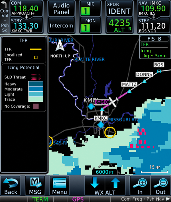
Latest FIS-B Weather Products and More Added to GTN 650/750 Series
We have incorporated new enhancements and features to our GTN 650/750 series touchscreen navigators. With the latest software update and a compatible ADS-B In receiver, pilots can now view new FIS-B weather products on the GTN. Also, when the GTN 650/750 is paired with a G3X Touch flight display in experimental/amateur-built aircraft, pilots now have the option to edit VFR flight plan information from the G3X Touch. These features and more are available immediately from Garmin Authorized Dealers for hundreds of aircraft makes and models.
New
FIS-B weather product support
When paired with a compatible ADS-B In product such as the
GTX 345 or GDL 88, pilots can now access the latest FIS-B weather products on
the moving map alongside flight plan information and dedicated weather pages
within GTN 650/750. These new weather products include lightning, cloud tops,
turbulence, icing (current and forecasted), graphical AIRMETs and center
weather advisories (CWA). This adds to the growing number of Garmin products
that already support these new weather products, including Garmin Pilot on
Apple mobile devices, G3X Touch and the aera 660 aviation portable.
G3X
Touch flight plan editing
Pilots who have a GTN 650/750 installed alongside a G3X
Touch flight display in an experimental/amateur-built
aircraft now have additional flight planning and editing options. VFR flight
plans can now be completed on the G3X Touch display, and then automatically
synced to the GTN for added convenience when using either the G3X Touch or GTN.
Additional
features
- The
GTN 650/750 now displays a selected altitude intercept arc on the moving map
when it’s installed with a Garmin primary flight display (PFD) such as the G500
TXi/G600 TXi, G500/G600 or G3X Touch. When pilots input a preselected
altitude on the PFD, the selected altitude arc will populate on the map page to
indicate where the aircraft will arrive at that particular altitude. - For
customers with SiriusXM Aviation Weather, pilots now have the option to alternate
between base reflectivity and composite reflectivity NEXRAD weather radar
imagery. - Pilots
operating into airports throughout the world that are not served by SBAS, can
now receive advisory vertical guidance (LNAV+V) while flying LNAV approaches
with the GTN 650/750. - When
SiriusXM aviation weather or FIS-B weather cannot be displayed on the GTN
650/750, the “no coverage” area of weather is transparent so pilots can still
view airports, basemap information and more. - Customers
receive a VNAV aural alert for Top of Descent (TOD). - Traffic
and weather from a GNX 375 can now be displayed within the GTN 650/750.
The latest GTN software upgrade is available immediately from Garmin Authorized Dealers for hundreds of aircraft makes and models. This upgrade is available at no charge. A dealer installation charge may apply. Garmin avionics are supported by our award-winning aviation support team, which provides 24/7 worldwide technical and warranty support.
The post Latest FIS-B Weather Products and More Added to GTN 650/750 Series appeared first on Garmin Blog.
https://www.garmin.com/en-US/blog/aviation/latest-fis-b-weather-products-and-more-added-to-gtn-650-750-series/
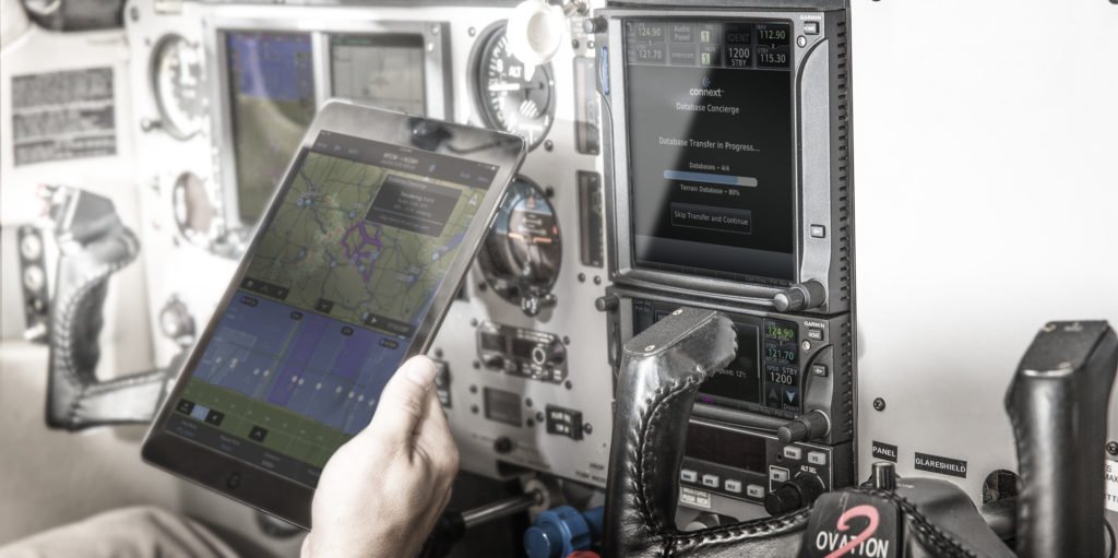
Garmin OnePak: All Your Database Needs, One Simple Solution
It’s finally complete. Your perfect airplane now has the
perfect panel. Those dual Garmin GPS navigators and flight displays you’ve
always wanted are installed, plus an aera series portable navigator to help
with flight planning and added cockpit situational awareness. These products
feature sophisticated data ranging from navigation data, charts, airport
diagrams, obstacles, terrain and more. For those flying IFR regularly, the FAA
requires a product’s navigation data to be updated every 28 days. For SafeTaxi,
obstacles and terrain databases, updates are available every 56 days. We’ve
created annual subscription packages for the US and Canada — known as OnePaks —
to more conveniently and affordably satisfy a single aircraft’s entire database
needs.
One aircraft. One
database package. One cost-effective price.
Our OnePak annual subscriptions offer significant savings for
an aircraft equipped with multiple Garmin products. For one annual price,
databases within OnePak subscriptions can be downloaded to multiple Garmin
avionics and one qualifying portable in a single aircraft. These databases
include the Garmin Navigation Database, AOPA Airport Directory, IFR enroute
charts, VFR sectional charts, Obstacles, SafeTaxi, Terrain and Basemap for
compatible products. OnePaks are compatible with the following flight decks,
flight displays, avionics, and portables:
- GTN 650/750 touchscreen navigators
- GNX 375/GPS 175 touchscreen navigators
- GNS 430/530 navigators
- G500/G600/G500H and TXi series glass flight
displays - G1000 NXi, G1000, G2000, G3000 and
G5000 integrated flight decks - G3X, G3X Touch and G900X glass flight
displays - aera 500/660/795/796 GPS portables
- GPSMAP 696/695 GPS portables
OnePak database subscriptions start at $649 and include a
Garmin Pilot Premium upgrade.
Wireless updates with
Database Concierge
Additionally, for aircraft with GTN 650/750 and GNX 375/GPS
175 series touchscreen navigators or select aircraft equipped with G1000 NXi,
our Flight Stream 510 can offer another level of convenience for updating
databases. Flight Stream 510 is a small, patented multimedia card enabled with
Wi-Fi and BLUETOOTH technology that enables communication between GTN 650/750 and
GNX 375/GPS 175 series navigators or G1000 NXi, and two compatible Apple or
Android mobile devices operating Garmin Pilot. Operators can simply download
new databases via Garmin Pilot on a mobile device, then wirelessly upload them
directly to the GTN 650/750, GNX 375/GPS 175 or G1000 NXi in the cockpit.
For more information about our OnePak database solutions, and to find out which best suits your needs, visit flygarmin.com.
The post Garmin OnePak: All Your Database Needs, One Simple Solution appeared first on Garmin Blog.
https://www.garmin.com/en-US/blog/aviation/garmin-onepak-all-your-database-needs-one-simple-solution/
New Upgrades for G1000 NXi-Equipped King Air Aircraft
We are pleased to announce new features and upgrades available for the G1000 NXi integrated flight deck in the King Air 200/250/300/350 series aircraft.
A new, Bluetooth-enabled
audio panel for the G1000 NXi integrated flight deck in the King Air offers an
expanded feature set alongside innovative sound quality. Home theater-like
music effects add to the rich audio characteristics provided by the audio panel,
allowing pilots to select bass boost levels, as well as equalizer effects,
including rock, classical and pop. Advanced auto squelch automatically adapts
to the noise level within the cockpit and allows for natural conversation
through headsets. It includes a six-place stereo intercom and support for up to
three stereo music inputs. Split-COMM mode allows the pilot and co-pilot to
broadcast independently on two separate frequencies and contains dedicated
pilot and co-pilot music and intercom volume control knobs. Additionally, a
built-in digital clearance recorder can record up to 60 seconds of selected
COMM radio transmissions so pilots can easily play back difficult clearances.
The first to introduce 3D Audio, we have incorporated 3D audio processing into the audio panel. With stereo headsets, incoming audio is spatially separated to reflect how people naturally process sound and conversation by differentiating audio sources by their unique locations or seat position. For example, sound from COMM 1 will come from the left, whereas sound from COMM 2 will sound as though it’s coming from the right. Using stereo headsets, listen to a demonstration of 3D Audio here: http://www.garmin.com/us/explore/intheair/how-does-3d-audio-work/
As a standard feature of the audio
panel, pilots can connect a smartphone or tablet via Bluetooth to easily make
or receive phone calls, stream audio entertainment or wirelessly connect to
select Garmin HD action cameras. Offering a seamless upgrade path, pilots and
aircraft owners can easily upgrade (or select as an option with a new G1000 NXi
installation) to the new audio panel as its slide-in replaceable and only
requires minor wiring modifications.
The GWX 75 weather radar is
also compatible with the latest upgrade for G1000 NXi-equipped King Air
aircraft, which offers exceptional range and a new, enhanced color palette that
features four-times more color contouring than traditional weather radars on
the market. The Doppler-based, solid-state GWX 75 offers a range of 320
nautical miles, horizontal scan angles of up to 120 degrees and to focus on an
area of interest, pilot-adjustable sector scanning. The GWX 75 also retains vertical
scan capabilities, which allows the pilot to focus on storm tops, gradients and
storm cell build-up at various altitudes. Optional features such as
Doppler-enabled turbulence detection and ground clutter suppression are also
available with the GWX 75.
Also included as part of this
upgrade:
- Split-screen view is available on the MFD,
offering a simultaneous view of maps, charts, checklists, flight plans and more
on a single screen. - Pilots can view decoded Terminal Aerodrome
Forecasts (TAF’s) on the primary flight display (PFD) and multi-function
displays (MFD).
For current King Air
owners and operators, the latest features are available immediately from select
Garmin Authorized Dealers as a free upgrade (installation and hardware charges
may apply). Optional equipment upgrades are also currently available. King Air
owners and operators may contact a Garmin Authorized Dealer for pricing
information. For more details regarding the G1000 upgrade for the King Air
series aircraft, contact Scott Frye at (913)-440-2412. For additional
information, visit: www.garmin.com/kingair.
The post New Upgrades for G1000 NXi-Equipped King Air Aircraft appeared first on Garmin Blog.
https://www.garmin.com/en-US/blog/aviation/new-upgrades-for-g1000-nxi-equipped-king-air-aircraft/