Category Archives for Aviation
Appareo Releases Highly-Capable Rugged LTE Telematics Gateway with 6 CAN Busses, Wi-Fi, Bluetooth, BroadR-Reach, Ethernet, and GPS
NEWS RELEASE
Appareo Releases Highly-Capable Rugged LTE Telematics Gateway with 6 CAN Busses, Wi-Fi, Bluetooth, BroadR-Reach, Ethernet, and GPS
FARGO, North Dakota (May 27, 2020) — Appareo today released a new product in the company’s award-winning line of telematically-enabled electronic control units (ECUs). The Gateway 260 is a rugged yet lightweight edge computing platform for mobile equipment applications that provides a wide range of communication technologies: Wi-Fi, Bluetooth, Cellular, GPS, BroadR-Reach, Ethernet, and controller area networking (CAN). The device is built with an IP67-rated rugged enclosure for use outdoors and for mounting on heavy machinery, and like all Appareo Gateways, the Gateway 260 is built on a popular distribution of embedded Linux (Yocto) with Docker support that allows developers to quickly deploy applications.
The Appareo Gateway 260 is unique in that it couples the capabilities of a modern LTE connectivity device and a powerful computational platform capable of receiving and processing data from a wide range of vehicle networks and buses.
“While other solutions require multiple, separate devices to accomplish computation and cloud connectivity, Gateway 260 was designed to aggregate local/wired communications and Wi-Fi/cellular connectivity in one box with powerful processing capabilities, lowering the total cost for our customers,” said David Batcheller, President & CEO of Appareo. “Our architecture that enables strong local area network integration between off-highway equipment and mobile devices like phones and tablets continues in the Gateway 260. This allows our customers to create mobile app experiences that control or monitor their machines using the operator’s portable electronic devices.”
For example, Väderstad and Appareo collaborated to design an entirely new machine control architecture for Väderstad planters and seeders, uniquely featuring the capability to control the machine using iPads through a Wi-Fi interface. The Appareo Gateway acts as the server for the user interface, contains all the control logic necessary to operate the machine, and commands other ECUs on the CAN bus to execute machine tasks or get information. The user has the ability to utilize an ISOBUS-compatible Virtual Terminal, an iPad display, or both at the same time. With the inclusion of an iPad as a control interface, the user is able to perform all functions wirelessly to the machine, which has made out-of-cab operations much more convenient. Väderstad was the first agricultural machinery manufacturer to utilize a mobile tablet in this way.
From remote diagnostics (securely accessing devices to troubleshoot equipment in real time) to inexpensively deploying firmware updates through differential software updating tools, Appareo Gateways offer a wide spectrum of capabilities.
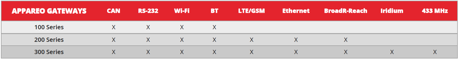
One company that integrated Appareo’s 300 Series Gateways for its telematic solutions is AGCO Corporation (NYSE:AGCO). AGCO utilized an Appareo 300 Series Gateway with Iridium (Nasdaq:IRDM) connectivity to expand AgCommand, AGCO’s complete, end-to-end, wireless telemetry solution for remote precision agriculture and machine monitoring. Appareo is one of only a few integrators in the world for the 9603 Iridium chipset — the smallest commercial two-way satellite transceiver — which enabled AGCO to become the first in agriculture to equip machines with connectivity on a broad, global scale. The Appareo Gateway can collect and distribute real-time data, product and performance data, health and asset management data, location data, security and recovery data, in addition to remote diagnostics and the possibility for future predictive maintenance capabilities.
To learn more about Appareo’s line of Gateways, visit www.appareo.com/products/highly-capable-telematic-products/.
# # #
https://www.appareo.com/2020/05/27/appareo-releases-highly-capable-rugged-lte-telematics-gateway-with-6-can-busses-wi-fi-bluetooth-broadr-reach-ethernet-and-gps/
Prop Talk Webinar Series

TUESDAY, JUNE 9 | 11 AM CENTRAL TIME
Our Prop Talk Series continues! Join Kris Garberg, President of Appareo Aviation, as he walks through some Stratus Insight tips and tricks, specifically showing features like the Vertical Weather Profile, Radar Forecast, and how to submit PIREPS. There will also be an interactive Q&A session at the end of the webinar.
Please note: It will be helpful to have a Stratus Insight account so you can interact with the app during the webinar, so be sure to take advantage of our 30 day free trial! You can find Stratus Insight in the Apple App Store.
Click here to register for the webinar.
*Registration is limited
https://www.appareo.com/2020/05/27/prop-talk-webinar-series/
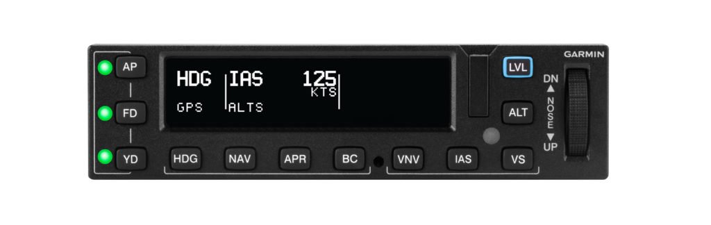
New Aircraft Models Approved for GFC 500 and GFC 600 Autopilots
Our GFC 500 and GFC 600 digital autopilots have received FAA Supplemental Type Certification in several aircraft models. The GFC 500 and GFC 600 deliver superior in-flight characteristics, self-monitoring capabilities and minimal maintenance needs when compared to older generation autopilot systems. The GFC 500 is intended for piston aircraft, while the GFC 600 is intended for high performance piston and turbine aircraft that have a wide range of speed and performance characteristics.
New aircraft models approved for the GFC 500 autopilot include:
- Aviat Husky
- Models: A-1, A-1A, A-1B, A-1C-180, A-1C-200
- Cessna 206
- Models: U206F (s/n U20602200 and later), TU206F (s/n U20602200 and later), U206G, TU206G, 206H, T206H
New aircraft models approved for the GFC 600 autopilot include:
- Cessna 425
- Models: 425
The GFC 500 autopilot uniquely integrates with the G5 electronic flight instrument or a combination of both the G5 electronic flight instrument and G3X Touch, G500 TXi or G500 flight displays to provide pilots with an economical and modern autopilot solution. The GFC 600 is designed as a standalone autopilot and also boasts superior integration potential when paired with the G500 TXi/G600 TXi or G500/G600 glass flight displays, Garmin navigators, as well as a variety of third-party flight displays, instruments and navigation sources.

The full-featured GFC 600 and GFC 500 autopilots provide thousands of existing general aviation aircraft with a simple, light-weight, cost-effective autopilot upgrade path. The GFC 600 and GFC 500 incorporate solid state attitude with robust self-monitoring capabilities to provide superior autopilot performance, greater reliability and safety benefits that are similar to the popular GFC 700 autopilot. In addition to traditional autopilot capabilities such as altitude hold, vertical speed and heading modes, the GFC 600 and GFC 500 also include altitude preselect, VNAV1, Level Mode, underspeed and overspeed protection and more. Pilots can also select, couple and fly various instrument approaches, including GPS, ILS, VOR, LOC and back course approaches when paired with a compatible GPS navigator.
As a standard feature on both the GFC 500 and GFC 600 autopilots, pilots receive Garmin Electronic Stability and Protection (ESP), which works to assist the pilot in maintaining the aircraft in a stable flight condition. ESP functions independently of the autopilot and works in the background to help pilots avoid inadvertent flight attitudes or bank angles and provides airspeed protection while the pilot is hand-flying the aircraft.
For customers who already have a G5 electronic flight instrument, the GFC 500 starts at a suggested retail price of $6,9952 for a 2-axis autopilot. The GFC 600 autopilot starts at a suggested retail price of $19,9952 for a 2-axis autopilot with electric pitch trim. Pricing is for retrofit installations only. The GFC 500 autopilot will also be available as an option on new Aviat Husky aircraft.
Garmin continues to add additional aircraft models to the growing STC list for the GFC 500 and GFC 600 autopilots. To view the most up-to-date aircraft STC list, to view certification programs that are expected to begin in the next 12-months, or to express interest in a specific aircraft make/model, visit: www.garmin.com/GFC500 or www.garmin.com/GFC600.
1. GTN navigator required
2. Installation not included
The post New Aircraft Models Approved for GFC 500 and GFC 600 Autopilots appeared first on Garmin Blog.
https://www.garmin.com/en-US/blog/aviation/new-aircraft-models-approved-for-gfc-500-and-gfc-600-autopilots/
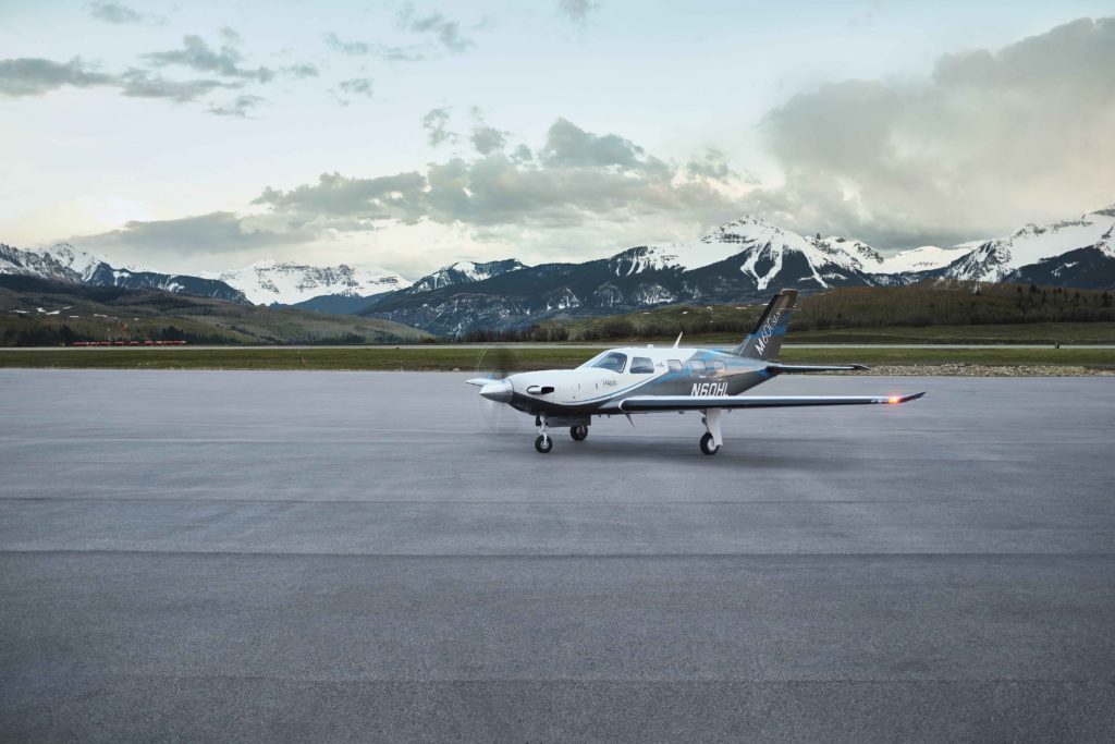
Garmin Autoland Achieves FAA Certification for General Aviation Aircraft
Garmin Autoland is now FAA certified and available on the G3000 integrated flight deck in the Piper M600. In the event of an emergency, Autoland will control and land the aircraft without human intervention. The award-winning system is also featured on the Cirrus Vision Jet and Daher TBM 940 and will soon be available on these aircraft, with additional aircraft approvals to follow.
“What started as a vision to develop the world’s first Autoland system for general aviation, became a reality today as we deliver one of the industry’s most significant innovations,” said Phil Straub, Garmin executive vice president and managing director of aviation. “Congratulations to the entire Garmin team who contributed to the development and certification of Autoland – one of the industry’s most forward- thinking technologies that will forever enhance aviation safety and save lives.”
In the event of an emergency, the pilot or passengers on board the aircraft can activate Autoland to land the aircraft with a simple press of a dedicated button. Autoland can also activate automatically if the system determines it’s necessary. Once activated, the system calculates a flight plan to the most suitable airport, while avoiding terrain and adverse weather, initiates an approach to the runway and automatically lands the aircraft – without pilot or passenger intervention.
Autoland takes into account a breadth of information and criteria during an activation, including a wide range of performance, operational and environmental factors. The availability of a GPS approach with lateral and vertical guidance to the runway is also required when the system is considering various airports and runways. Even further, the system will automatically communicate with air traffic control, advising controllers and pilots operating near the aircraft of its location and its intentions.
Throughout an Autoland activation, the G3000 integrated flight deck provides passenger-centric visual and verbal communications in plain-language so passengers in the aircraft know what to expect. The flight displays show the aircraft’s location on a map alongside information such as the destination airport, estimated time of arrival, distance to the destination airport and fuel remaining. Airspeed, altitude and aircraft heading are also labeled in an easy-to-understand format. Passengers also have the option to communicate with air traffic control by following simple instructions on the display using the touchscreen interface on the flight deck.
The Garmin Autothrottle system is used to automatically manage aircraft speed, engine performance and engine power so the aircraft can climb, descend or maintain altitude as needed during an Autoland activation. On approach to land, the system initiates a controlled descent to the airport. If the aircraft needs additional time to descend or slow down during the approach, the Autoland system initiates a standard holding procedure. When aligned with the runway, the landing gear and flaps are automatically extended and the aircraft continues its descent. On the runway, automatic braking is applied while tracking the runway centerline to bring the aircraft to a full stop. Engine shutdown is also automated so occupants can safely exit the aircraft.
At any time, a pilot can easily deactivate an Autoland activation. With a single press of the “AP” autopilot key on the autopilot controller or the autopilot disconnect button on the controls, an Autoland activation can be canceled. The flight display shows a message that confirms Autoland has been deactivated and in the event of an accidental deactivation, the system shows passengers how to reactivate Autoland if needed.
Garmin Autonomí, a family of autonomous safety solutions, encompasses Autoland, Emergency Descent Mode (EDM) and Electronic Stability and Protection (ESP). These technologies add to the safety enhancing tools and capabilities of a Garmin-equipped flight deck. For example, in the event an aircraft loses pressurization, EDM is capable of automatically descending the aircraft to a preset altitude without pilot intervention to help avert hypoxic situations.
ESP further enhances the Autonomí suite by working to assist the pilot in avoiding unintentional flight attitudes beyond that for normal flight. ESP works in the background while the pilot is hand flying the aircraft to help pilots avoid inadvertent flight attitudes or bank angles. Should the pilot become inattentive while hand flying the aircraft and exceed pre-determined pitch, roll or airspeed limitations, Garmin ESP activates and the pilot will feel pressure on the flight controls that guide him/her back to a recommended flight limit.
For additional information regarding the Garmin Autonomí family of autonomously activated flight technologies, visit www.garmin.com/Autonomi.
The post Garmin Autoland Achieves FAA Certification for General Aviation Aircraft appeared first on Garmin Blog.
https://www.garmin.com/en-US/blog/aviation/garmin-autoland-achieves-faa-certification-for-general-aviation-aircraft/
Appareo Releases Major Upgrade to Web-Based Flight Data Analysis Software
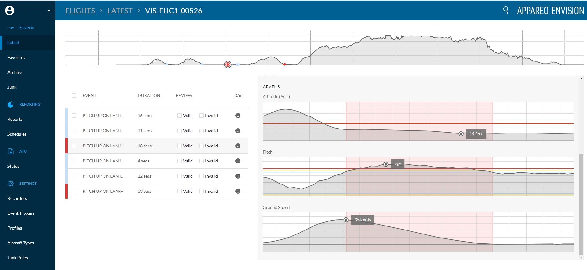
FARGO, North Dakota (May 18, 2020) — Appareo today released a major architectural upgrade to Appareo EnVision, the company’s analysis software system for Flight Data Monitoring (FDM) or Flight Operations Quality Assurance (FOQA) programs. Appareo EnVision is a web-based application that allows fleet operators to access past and current flight data, generate detailed reports, and trend the safety improvements in their operations. Prior to this release, the software accepted flight data captured by Appareo’s Vision 1000 cockpit recorder. With this architectural rewrite, the Appareo EnVision web app can now accept flight data from other devices, including other Appareo flight data recorders and even third-party sources.
“While many flight analysis applications require significant technical capability to operate with effectiveness, EnVision was built with a focus on ease of use” said David Batcheller, President & CEO of Appareo. The software provides deep access to raw data while delivering it in a simple, clean interface to automatically filter flight data and identify flights that require further review.
The Importance of Flight Analysis
FDM and FOQA programs have proven effective in improving safety and decreasing the occurrence of incidents or accidents when the program follows three simple practices: 1) identify deviations, 2) implement corrective actions, and 3) measure results.
Identifying deviations from standard operating procedures (SOP) is not an indication of irresponsible or deliberately malicious behavior by pilots. Deviations often occur because humans are susceptible to the “normalization of deviance.” This phrase describes a process in which deviance becomes normalized if it doesn’t result in an instantaneous negative consequence. While some operating procedures may seem inconvenient or unimportant, the right mix of variables could result in a deviance turning deadly. That is the reason behind the expression, “aviation regulations are written in blood.”
Appareo CEO David Batcheller shares his own personal experience with normalization of deviance: “I moved into a new neighborhood which had a stop sign near my house. For months I didn’t see another car when I came to the stop sign every day. After a while, I started to roll through the stop, then coast through the stop, and eventually I forgot the stop sign was there entirely. Flash forward to harvest season when I discovered that the intersection became very busy, and I was nearly broadsided by a truck as I ignored the stop sign. Fortunately that was a near miss, but that incident could have been fatal. It’s the kind of thing that routinely happens in all walks of life, flight operations included. Flight Data Monitoring and Flight Operations Quality Assurance programs should be thought of as the kindly local sheriff in the rearview mirror who is ready to provide a reminder that rules are important when our more fallible human inclinations take over.”
How It Works
Data is transferred from an aircraft to a local computer via SD card, then uploaded to Appareo servers for analysis. That transmission can happen instantaneously or it can be scheduled for a different time of day, based on the user’s preferences. “The scheduling feature was developed for our customers who have operations in remote locations with limited internet bandwidth,” said Batcheller. “They appreciate the ability to schedule their data file transmission to take place during periods of low network activity.”
Once data is received, the EnVision software parses all flight data against customized event triggers that were defined by the user based on their organization’s flight operating procedures. The process of configuring those event triggers is one of EnVision’s most powerful features; using a simple interface and drop-down menu, users can define the events that are important to monitor, and specify the parameters that indicate when a flight has deviated from flight ops.
Detailed reports are easily generated from those events, delivering the information that operators want to monitor and the ability to trend that information over time. Comprehensive data for every flight is archived on the Appareo servers, giving customers convenient online access to their data whenever it’s needed.
Appareo EnVision is offered as a per-aircraft subscription service with no user limits, and includes the hosting of stored flight data. To learn more about Appareo’s turnkey flight data monitoring solutions, visit Appareo.com/FDM-FOQA.
# # #
About Appareo
Appareo is a recognized leader in the custom design, development and manufacture of innovative electronic and software solutions for aerospace. Through the creative application of cutting-edge technologies, Appareo creates complex end-to-end solutions that include both mobile and cloud-based components. The company is privately held, with headquarters in Fargo, N.D., and design offices in Tempe, Ariz. and Paris, France. All products are built and supported in the USA.
About FDM and FOQA
FDM and FOQA programs are one of the NTSB’s Top 10 Most Wanted and an area of strong recommendation from the NTSB to the FAA for new rulemaking to improve the safety of Part 135 operations.
Media Assets
www.appareo.com/media
https://www.appareo.com/2020/05/18/appareo-releases-major-upgrade-to-web-based-flight-data-analysis-software/
ATC Radio Transcription & Playback is available with Stratus Insight
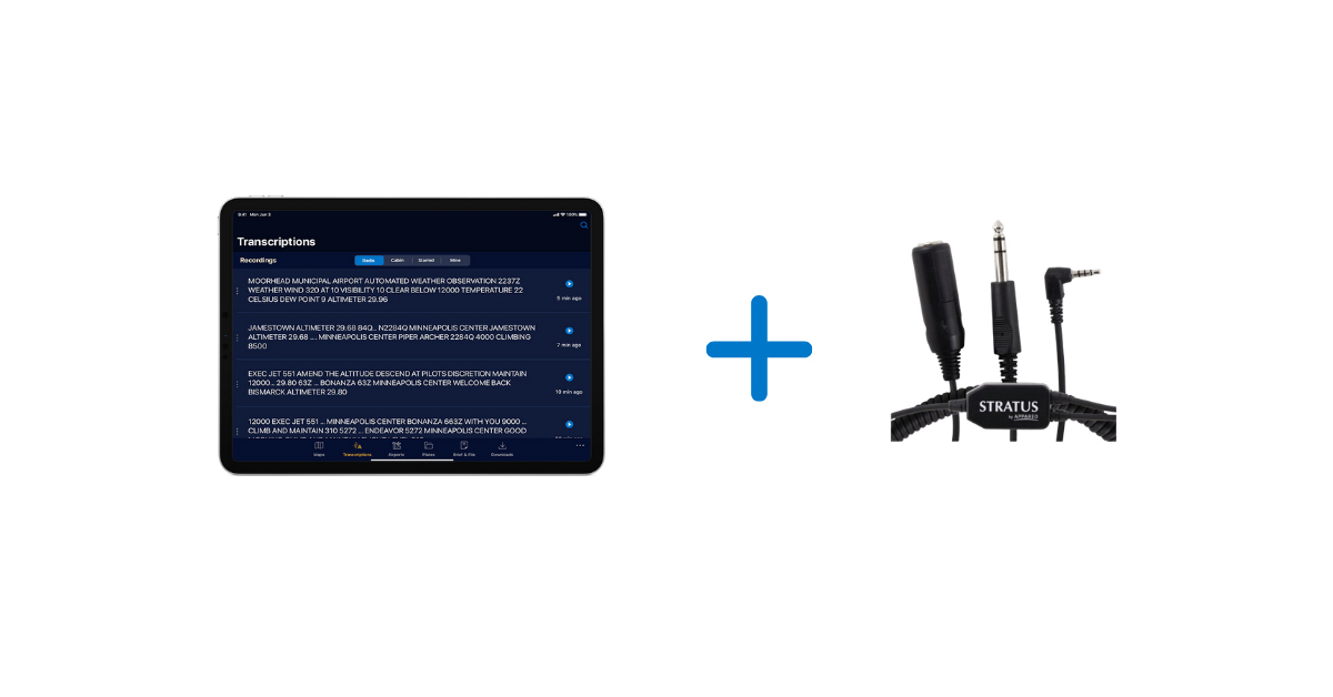
This new AI technology is the baseline for exciting features we have in our app roadmap, which is focused on creating a safer, more convenient way to fly.
When paired with a Stratus Audio Cable, the ATC Radio Transcription feature works similar to visual voicemail. ATC communications are converted into text and displayed directly above the audio playback line, providing a helpful visual assist for referencing previous audio clips. This enables pilots to receive a clearance, ATIS, or other important ATC communications without needing to write them down.
The speech recognition and language understanding technology that drives the Radio Transcription feature was custom-designed by our Artificial Intelligence (AI) division.
At a global scale, speech recognition, translation, and transcription features are commonplace (e.g. Alexa and Siri). However, ATC communications present many challenges for these common speech recognition systems. The high rate of speech, noisy signal, narrow frequency band, and unique location identifiers are among those challenges. We identified that shortfall in the existing technology and set out to develop a speech recognition system customized for aviation.
We also use Natural Language Processing to interpret the output of the speech recognition system and present it in a more pilot-friendly format. For example, tail numbers, altitudes, runways, and frequencies are transcribed in a way that will be more helpful to pilots.
Comparison example:
| A typical speech recognition system | Appareo’s custom aviation speech recognition system | |
| Altitudes | one zero ten thousand | 10,000 |
| Call signs | November two two eight four quebec | N2284Q |
| Runway | Runway three six one eight | runway 36 18 |
| Frequencies | one two zero point four | 120.4 |
The Stratus Audio Cable available to purchase and is necessary to enable the Radio Transcription and Playback features. For more information, visit www.stratusinsight.app.
Download Stratus Insight today and take advantage of our 30 day free trial.
https://www.appareo.com/2020/05/14/atc-radio-transcription-playback-is-available-with-stratus-insight/
NTSB recommends that Part 91, 121, and 135 aircraft should be equipped with FDM
The FAA released a Fact Sheet that lists several NTSB recommendations, followed with the FAA’s considerations and actions being taken. Flight Data Monitoring (FDM) is one of the recommendations for how to improve the safety of Part 135 aircraft flight operations.
“The crash-resistant flight recorder system should record cockpit audio and images with a view of the cockpit environment to include as much of the outside view as possible,” the NTSB recommended on the fact sheet. However, the document stated that the FAA is not considering rulemaking at this time for these recommendations, saying, “The FAA will examine possible ways of polling operators through their aviation safety inspectors to identify voluntary flight data monitoring (FDM) system equipage rates.”
Read the full FLYING article: FAA Responds to NTSB’s “Most Wanted” Safety Recommendations.
View the NTSB Most Wanted List for 2019-2020 here.
View the FAA Fact Sheet here.
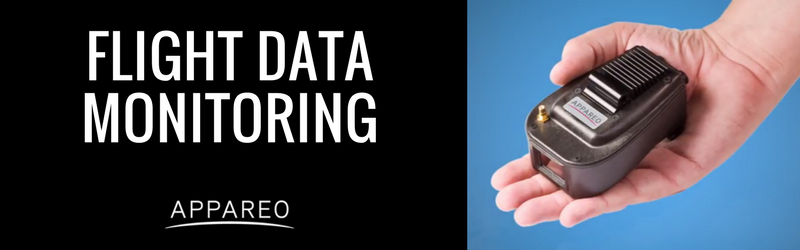
FDM SOLUTIONS FROM APPAREO
Appareo provides a turnkey flight data monitoring system that includes the Vision 1000, a low-cost flight data recording solution that can be utilized on any aircraft. Click here to learn more about our flight data monitoring and flight operations quality assurance solutions.
https://www.appareo.com/2020/05/11/ntsb-recommends-that-part-91-121-and-135-aircraft-should-be-equipped-with-fdm/
So, how does Stratus Insight compare?
We’ve put together a features table comparing Stratus Insight, ForeFlight Pro Plus and
Garmin Pilot so you can see how Stratus Insight compares with other flight apps.
STRATUS INSIGHT |
FOREFLIGHT (PRO PLUS) |
GARMIN PILOT |
| $99.99 / year | $199.99 / year | $149 / year |

1. Stratus Audio Cable required
2. Improved time and fueling calculating is available with ForeFlight Performance Plus ($299.99/annually)
3. Detailed Aircraft Performance Profiles is available with ForeFlight Performance Plus ($299.99/annually)
We’re offering a 30 day free trial so you can see for yourself.
Download the app today!
https://www.appareo.com/2020/05/05/so-how-does-stratus-insight-compare/
12,000 Mile Journey: Wisconsin to Brazil and Back in a Homebuilt Aircraft
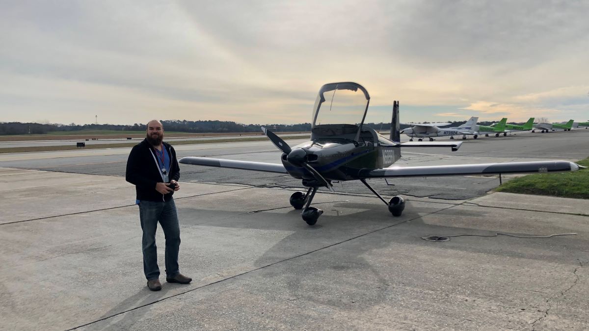
Guil Barros was browsing the Aeromart at AirVenture Oshkosh, an annual U.S. gathering of aviation enthusiasts, when he spotted an RV-9A tail and empennage kit in a caged off area. Three years and about 2,500 after-work and weekend hours later, he had himself a fully built aircraft.
Barros works in computer technology, and prior to building
his own aircraft, had logged about 40 flight hours a year as a hobby aviator in
his older 172. He didn’t necessarily consider himself a serious aviator, and
certainly not a plane builder.
But suddenly Barros was the owner of that RV-9A kit — and
filled with the determination to eventually fly it for real.
“It’s a huge project, right?” he said. “It seems
insurmountable. When you start, there’s about 15,000 rivets, which means you
have to drill out about 15,000 holes, you have to deburr about 15,000 holes,
you have to prime hundreds of parts, you have to deburr hundreds of parts.”
To maintain motivation, and maybe a little bit of sanity,
Barros just took it day-by-day, tackling small tasks each day.
“It’s just about managing a big project and managing your
expectations for what you’re going to get out of it every week,” he said.
Fortunately, Barros is a part of a large experimental aviation community. He had plenty of experts and fellow aircraft builders, including Garmin Team X, to lean on. And throughout the process, Barros had airplane mechanic friends come and look over the airplane.
“I wanted as many people as possible to look at the airplane
before I flew it,” he said. “I told them, ‘You’re not going to hurt my feelings
if you find a problem with it.’”
Once it was fully built, a Federal Aviation Administration
official inspected the aircraft, which was followed by a 40-hour flight test
period within a limited area. By the end of that test period, Barros was having
some serious fun in his new airplane. He spent the next 18 months flying it
wherever he could.
Eventually, Barros felt ready for a serious trip. While
Alaska was tempting, Barros spent the first 19 years of his life in Rio de
Janeiro, Brazil. He felt strongly that a return to his homeland and family
would be the most meaningful trip he could take after all those years building an
aircraft that could take him there.
Planning the trip — including building a route and itinerary, planning out fuel stops, getting approvals, researching lodging options in the various countries, and packing and prepping equipment — overtook his after-work and weekend time that was once spent building his airplane.

2020 Takeoff
Finally, in early 2020, Barros and his wife took off from the
Madison, Wisconsin, airport. They flew south to Florida, headed east towards
The Bahamas, the Dominican Republic, Puerto Rico and Antigua, and then south along
the French island chain of the Caribbean — touching down to fuel up and spend time exploring
each destination.
Finally, a little over a week in, they reached South
America.
The trip had been fairly straightforward through that point, but South America doesn’t have as much general aviation, so it took time to obtain approvals and airport and weather information. That’s where his inReach® satellite communicator came in handy.
“It was a lot of planning and a lot of keeping our eye on what the weather looked like,” Barros said. “I think that was where the inReach Mini really, really shined. I don’t think I would ever do a trip like this without being able to communicate with the ground.”
Throughout the flight, Barros used the inReach to
communicate via two-way text with airport officials and pilot friends on the
ground.
“We were getting messages on the inReach throughout the
flight about weather reporting and conditions,” he said. “Or they would tell us
‘Hey, the weather here is not great, why don’t you continue to this next
airport that’s only another hour away, and we’ve already called them to check
that there’s fuel there waiting for you.’ It made a stressful and detailed
planning situation significantly easier.”
They also had the inReach tracking their trip and sending track points to their live MapShare page so friends, family members, fans and the media could follow along.
“We had a lot of people watching the trip,” he said.
Highlights from
12,000 Miles
It certainly was a trip of a lifetime for Barros and his
wife. They relished the new sights of his homeland from a bird’s-eye view, such
as flying over the Amazon River.
“That was absolutely gorgeous,” he said. “Green — so many different tones of
green. Seeing the hills and the rivers from above was just incredible.”
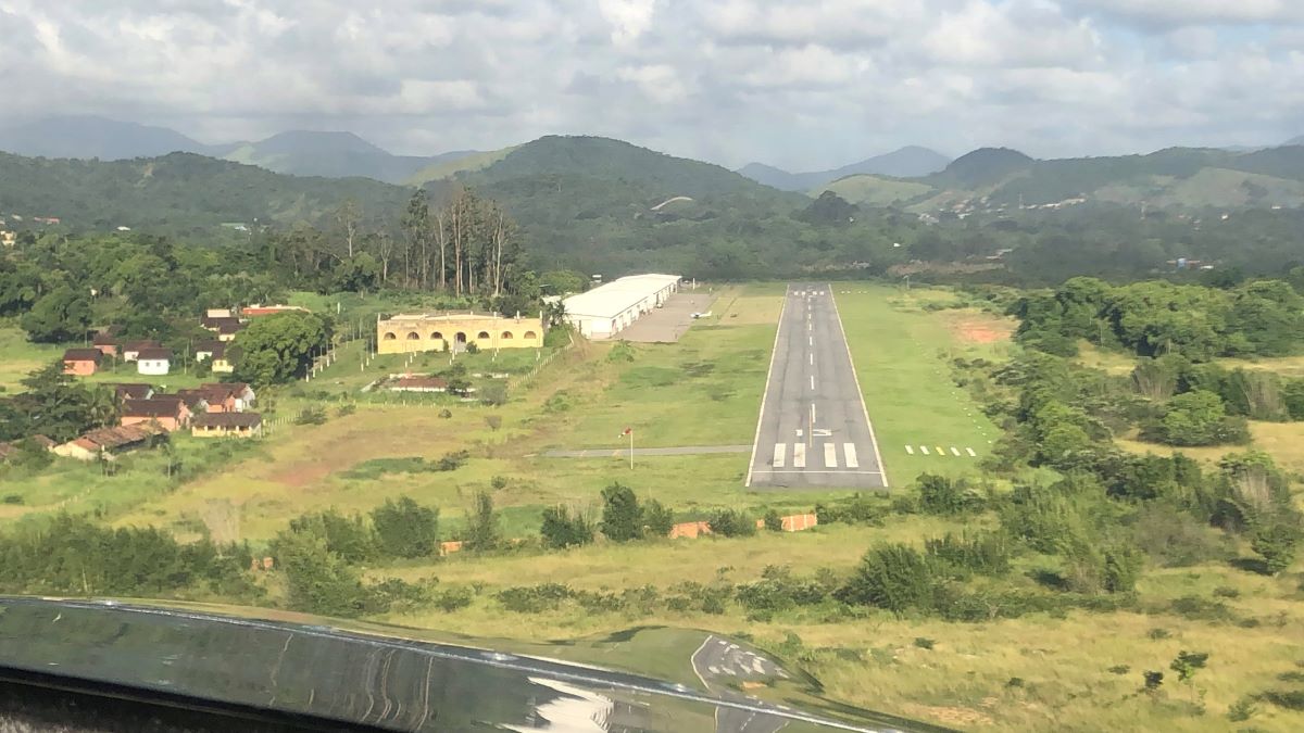
They also enjoyed their stops at some of the smaller, lesser-known
airports along the way, like the one that was within the Amazon rainforest.
“You’re suddenly in the rainforest, right?” he said. “It’s
like you’re in a movie. You’re in a gorgeous forest with these animals and
these birds that you only see on TV. It was incredible.”
Barros was charmed by the people he met along the way, too,
who offered space in hangars, places to stay the night and dinners at local
flying clubs.
One airport in Brazil had a more complicated runway than he was used to. It was a little shorter and tighter, with surrounding hills, and he felt apprehensive about flying in and out. But while touring the area, Barros got to chatting with a man who turned out to be a flight instructor.
“He said, ‘Let’s go – we’re going to get you comfortable,’”
Barros said. “So we hopped in an airplane and spent a couple of hours just
practicing getting familiar with that airport.”
And when he finally touched down in Rio, Barros was met with
a crowd of people and fanfare.
“The story that the news put out was about the wayward son
of Brazil coming back in his homebuilt aircraft,” Barros said, laughing. “They
were excited about it.”
On his way back, Barros opted to fly along the coast of
Brazil.
“That was just one beautiful flight after another following
the eastern shore of Brazil,” he said. “The views were just of beautiful ocean
and beaches. It was phenomenal.”
Once he got back to Wisconsin, the only thing Barros could think
of to have done differently was pretty simple.
“I just wish I had done it over six months instead of one month,” he said. “There was so much to see and so many people we wanted to spend time with that we met along the way.”

Trip Takeaways
While the trip was beautiful and filled with positive
experiences, it did take immense planning and logic, both beforehand and along
the way. His biggest piece of advice? Plan ahead.
“It’s important to keep an eye on where you’re going,”
Barros said. “What is the complexity of doing this? Do the places that you’re
going usually handle general aviation? Because if they don’t, it’s going to be
more complicated.”
He also recommends that pilots be aware of where they’re
going to be flying when packing survival gear. The most nerve-wracking portion
of the Wisconsin to Rio journey for Barros was the flight from Grenada to
Georgetown, which was the longest stretch over the ocean he encountered. He and
his wife wore life jackets for the entire flight.
But, in the end, after 600 gallons of fuel, 92 hours in the air and 12,000 miles flown in his homebuilt aircraft, Barros wants other aviators to know one thing:
“It’s not difficult,” he said. “This type of trip takes planning, but it’s not hard. And, ultimately, it’s such a cool experience. So just do it.”
Learn more about Barros’ journey to Brazil and back on his YouTube, Instagram and Facebook pages.
NOTICE: To access the Iridium satellite network for live tracking and messaging, including SOS capabilities, an active satellite subscription is required. Some jurisdictions regulate or prohibit the use of satellite communications devices. It is the responsibility of the user to know and follow all applicable laws in the jurisdictions where the device is intended to be used.
The post 12,000 Mile Journey: Wisconsin to Brazil and Back in a Homebuilt Aircraft appeared first on Garmin Blog.
https://www.garmin.com/en-US/blog/aviation/wisconsin-to-brazil-homebuilt-aircraft/
Appareo Releases Crash-Hardened Recoverable Data Module with Auto Bus Detection
Weighing less than two pounds, this rugged and compact enclosure withstands DO-160G category tests to ensure the survival of critical flight data.
FARGO, North Dakota (April 29, 2020) — Appareo today announced a new addition to the company’s line of crash-survivable, remote-mountable, flight data recording modules for rotorcraft and fixed-wing aircraft. The Recoverable Data Module, model 300 (RDM-300) is a small, lightweight, flexible, and affordable crash-hardened flight data recorder that was originally developed as a custom solution for a customer, and has now been equipped with an auto-detect feature for ARINC or serial buses, making it easily installed in any type of aircraft.
While there are regulatory requirements for commercial aircraft to be equipped with flight data recorders, there are no equivalent requirements for many smaller aircraft. Even so, aircraft manufacturers and large fleet operators have realized the benefits of recovering flight data for the benefits of helping investigators determine if an incident or accident was caused by an airplane system problem, an external event, or pilot error. Historically, this flight data has contributed to airplane system design improvements.
One airframe manufacturer who decided to invest in the benefits of recoverable flight data collaborated with Appareo to design a small and lightweight device that could meet high survivability standards.
“This module is ideal for aircraft that are not required to carry ED-112 compliant, large, heavy data recorders, but rather, for applications where reliable survivability of flight data provides great business and investigative value,” said David Batcheller, President & CEO of Appareo.
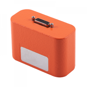 The RDM-300 is easy to incorporate into any aircraft, automatically accommodating the aircraft’s bus speed, and easily configurable to recording preferences. Once installed, the unit can record more than 500 parameters per second to the non-complicated, solid-state memory within the device. Weighing less than two pounds, the RDM-300 perfectly balances rigorous survivability needs while optimizing the size and weight of the product.
Although typically used to collect parametric data from ARINC 429 buses or other serial interfaces, the RDM-300 can also be configured to collect cockpit voice recorder (CVR) or cockpit image data.
For full technical specifications, refer to the RDM-300 Data Sheet.
# # #
https://www.appareo.com/2020/04/29/appareo-releases-crash-hardened-recoverable-data-module-with-auto-bus-detection/